
|
|
Mountain/Rock |
|---|---|
|
|
39.20590°N / 121.8197°W |
|
|
2120 ft / 646 m |
|
|
Overview
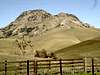
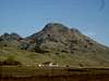
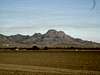
The Sutter Buttes have been dubbed by many “The Smallest Mountain Range in the World.” They are of volcanic origins, and are a geologic anomaly in that they are only 10 miles in approximate diameter. It is actually a cluster of peaks, of which the North, South, & West Buttes have the most prominence. The Buttes lie approximately 50 miles northwest of Sacramento, and rise abruptly from the flat Sacramento Valley, between the Sierra & Coast Range. Indeed, South Butte, the highest of the group, is the Sutter County highpoint.
The Sutter Buttes have enchanted many, but actual access has been limited due to the fact that the buttes have been surrounded by privately held land for quite some time, primarily limiting access to that associated with guided trips by the Middle Mountain Foundation. The Yuba Historical Society will be leading (payed) hikes throughout various locations in the buttes from the end of February through May, 2008 (see the Additional Reading, Sources of Information section below).
 |
 |
 |
 |
Sutter Buttes as a public resource?!
Acquisition of the Sutter Buttes by The State has been long held as a priority, but political interference, lack of funding, & poor timing have hampered acquisition. Despite this, an incredible phenomenon recently transpired when the owners not only decided to sell a coveted parcel of land in the Sutter Buttes, but included a $396,000 gift value so the State could close the deal. The sellers are listed as Circle H LLC Corporation and Joseph Hughes- one should give them their prop’s for this generosity. This land is now California State Park property. The parcel acquired is a 1,750 acre area known as Peace Valley, & is located on the north end of the mountain range, northwest of North Butte.
From an email I received from California State Parks, "State Parks is currently working on a resource inventory, interim management plan, as well as a sensitive easement issue for access into the property."
Also, while the actual date when the park will be open to the public was unidentified, they hope to have at least limited access in the near future. Currently the land is ”new and not currently available for public use, pending necessary planning, facility development and staffing,” so please respect this initial waiting period before State Parks gives the official OK to visit.
Inquiries about the park and public access should be directed to the State Parks Northern Buttes Valley Sector, 525 The Esplanade, Chico, CA 95926 (530) 895-4304.
Getting There
South Butte
For the record, access to the South Butte is limited to Authorized Personnel (authorization given by, or better phrased, NOT given by the private land owners). Credentials will be checked and violators prosecuted. See the "Red Tape" section. What this means is that it is off limits. Fine views can be had of the South Butte from Pass Road, which runs along the south side of the Sutter Buttes.
Despite this, however... stories abound of adventurous individuals braving blatant "No Trespassing" signs to seek the coveted summit of the South Butte, highest of the Sutter Buttes & highpoint of Sutter County.
Most seem to allude to performing this illegal act under the cover of darkness (many using the benefit of a full moon), though some brazenly audacious individuals have claimed broad-daylight ascents. There seem to be repeated mentionings of a locked gate, behind which lies a steep yet well paved road that leads to within a few hundred feet shy of the summit. Some minor bushwhacking & scrambling reportedly are all that separate one from the summit at this point. While some might claim to know exactly where this is, who knows whether this is true or not... If pressed, this same person might mumble something about said gate being something like 3.8 miles east of the West Butte Rd-Pass Rd junction, with a broad shoulder some .3 mile prior (W) on a saddle that might fit a personal vehicle...
While numerous roads exist that lead to scenic Pass Rd (the one that runs south of the Buttes) from Colusa, an anonymous source recommends avoiding the potential for driving around lost for hours on inconsequental levee roads not shown on maps one is likely to have along by just driving along highway 20 from Colusa some 13 miles or so to/through the small settlement of Tarke. After taking a L on W Butte Rd, a leisurely & scenic drive leads to Pass Road. Hanging a R on Pass Road takes one directly past the S side of the South Butte...
This interesting (hypothetical, mind you) anecdote was provided by the infamous & enigmatic DMT:
Well, there's a road that runs along the south foothills of the Buttes. Can't remember the name off the top of my head and my map is... well, I can't remember. (South Mountain? South Pass? Something like that. It's on the county map) [Pass Road is the name]
Along that road is a gate and a paved access road that winds up the mountain to a saddle. From that saddle a very cool tramway leads to the top of the peak.
Now, not that I have personal experience with this mind you, but if a person had a mind to climb this mountain, she might consider doing it at night on a full moon, say in September or October.
Park up the road a piece at a pass, wait for a lull in traffic (you can see cars a long way off) and jog down to the access road. Hop the gate and hike up the road. It's steep! Or allegedly steep that is.
I heard you can just hike up along side the tramway, then work your way James Bond style through the radio complex. There are catwalks and Warning Signs all over the place. You may half expect some ninja warriors to jump out at you. If this is a fall evening you can almost count on the wind howling, and I mean howling, over your head.
Once you're through the radio complex you can work your way over some outcrops to the actual high point of the mountain. If it's a clear night and at that time of year it almost surely will be (just wail till it is), you'll be able to see the lights of the Sacramento Valley all around you. I bet it's quite inspiring in its way.
I'd allow 4 hours for the adventure and that would leave ample time to screw around on the summit, drink some brews, burn some native herbs and perform satanic rituals beneath the full moon.
Or so I heard...
North Butte via Middle Mountain Foundation
The Middle Mountain Foundation is based in Sutter, directly beneath the beautiful Sutter Buttes & just outside of Yuba City. Contact them to arrange for a guided hike up the North Butte.
To reach Yuba City...
...from the Bay Area:
Take 80E towards Sacramento. Slightly before Sacramento, take the 5/99 exit north towards Redding. Take the 99N (shared with the 5N for awhile). At a certain point it will be the 70N as well. Stay on 70N when it splits from 99N. At Marysville take 20W a short distance to Yuba City. Approximately 127 miles (2:15).
...from Sacramento:
Take the 5 north towards Redding. Continue on the 99N when the 5 veers W. At a certain point it will be the 70N as well. Stay on 70N when it splits from 99N. At Marysville take 20W a short distance to Yuba City. Approximately 43 miles (:45).
...from Redding:
Take the 5S. At Red Bluff, take the Antelope Blvd-Highway 36-Highway 99 exit. Follow 99 south, through Chico. Hang a L (E) on highway 20 at Yuba City.Approximately 117 miles (2:10).
Various locations throughout the buttes via the Yuba Historical Society
The Yuba Historical Society is another option to see the Buttes by paying others. The society is located in Marysville (see Additional Reading, Sources of Information), directly east of Yuba City (see above) on highway 20.
Scenic Sutter Buttes Circumnavigation by Car
This scenic loop recommendation is provided by califb
There is a paved public road that winds all the way around the Sutter Buttes. The entire drive is approximately 50 miles and although the road is narrow and windy in many places the scenery is quite beautiful (breathtaking in the springtime) and well worth the time.
To get there you take Hwy 20 West from the intersection of Hwy 20 and Hwy 99 in Yuba City approximately 7 miles to the Sutter turn off at Acacia Rd.
Turn Right (North) onto Acacia Rd. and continue about 2 miles to the base of The Buttes where Acacia Rd. turns sharply to the left (West) and becomes Pass Rd. (from here on you will only be making right hand turns at intersections so ignore any roads with similar names that may be on your left).
Continue West on Pass Rd. for approximately 5 miles until you come to West Butte Rd. on your right (North). which is just past the West Butte Rd. that goes to the left. Turn right (North) onto West Butte Rd. and continue approximately 12 miles where the road will make a sharp right hand turn and become North Butte Rd.
After about five miles the road will make a sharp left hand turn and become Pennington Rd. Continue on Pennington (toward the East) for about four miles until you come to the stop sign at Township Rd. Turn right (South) onto Township Rd. and continue about 3 miles until you come to the stop sign where Township Rd. ends at Clark Rd.
Turn Right (West) onto Clark Rd. After about a mile and a half Clark Rd. will make a sharp left hand turn (South) where it becomes East Butte Rd. Continue South on East Butte Rd. for about three miles until you come to the stop sign where East Butte Rd. ends at Butte House Rd.
Turn right (West) onto Butte House Rd. and continue about 2 miles through the town of Sutter until you come to the stop sign at Acacia Rd. Turn left (South) onto Acacia Rd. and continue about two miles to the stop sign at Acacia Rd. and Hwy. 20.
Turn left (East) onto Hwy 20 and continue approximately 7 miles back to the Hwy 20 and Hwy 99 intersection in Yuba City.
RED TAPE
In a word, yes.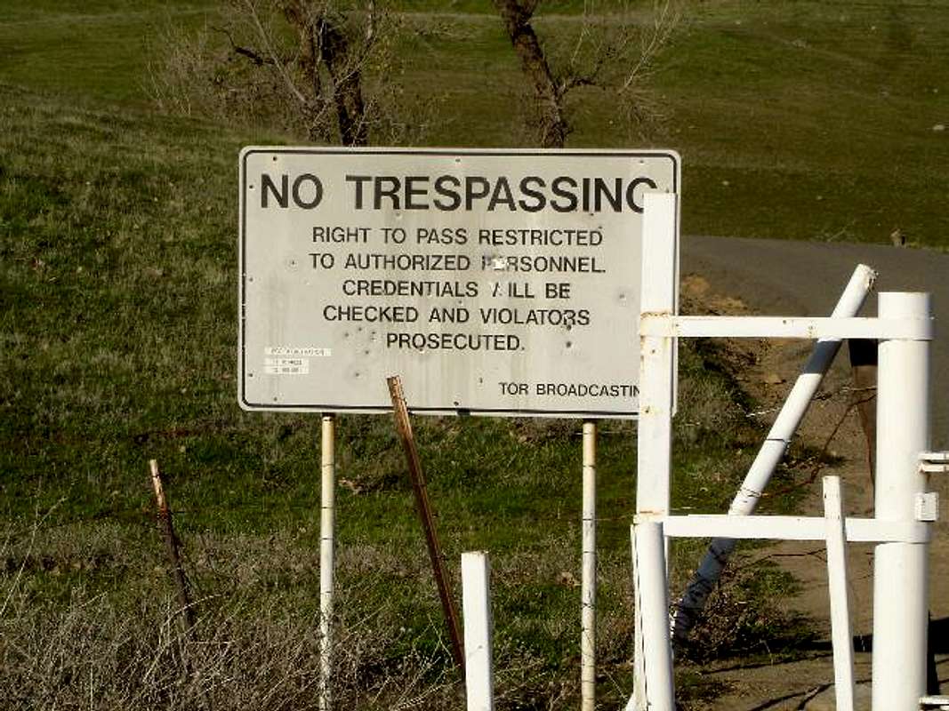
Access is restricted throughout the range. The closest legal options available are provided by the Middle Mountain Foundation & Yuba Historical Society.
For $35, the Middle Mountain Foundation will guide your group to the summit of North Butte. Well, almost to the summit- some 30-40 feet short of the top. For highpoint seekers, it is a moot point as the highpoint is located at the top of the South Butte (closed to public access) anyway, not North Butte.
The Yuba Historical Society will also be leading hikes throughout various locations around the buttes from the end of February through May 2008. Each trip will be led by experienced guides knowledgeable about this fascinating mountain. There is a charge for these excursions. Those interested can phone Daniel Barth at 530-741-0509.
The only current legal access to the Sutter Buttes (for a fee):
• Middle Mountain Foundation
• Yuba Historical Society
330 9th Street
Marysville, CA 95901
530-741-0509
SP member Frank Poole offers this advice regarding property ownership of the Buttes & how it relates to access (I couldn't get ahold of him- if you are able to or are familiar with these laws, please contact me!!):
The Sutter Buttes were federal land, and were settled prior to survey. As a result, the original federal surveys show pre-existing roads. There is a lot more legal access to the Buttes than is acknowledged. See Western Aggregates v. County of Yuba 101 Cal. App 4th 278 for the legal theory.
State Parks seems to have political inhibition to asserting the public's right access on the existing road from North Butte Road to the park property.
Middle Mountain Foundation (which is a neighboring landowner) and other neighboring landowners don't want a park, and don't want any access other than their own.
There are no peaks in the park - it is a valley and rolling hills. MMF owns North Butte; the Davis family owns South Butte; Peter Steidlmayer owns West Butte; The Laney/Coats family owns Two Sisters; and so it goes.
 |
External Links
• A visit in broad daylight - Jan 8, 2006
• California county highpoints page
• Sutter County "high point" trip report from Nov, 2001.
• USGS' page on the Sutter Buttes
Additional Reading, Sources of Information
• California County Summits, by Gary Suttle, Wilderness Press, 1994 (ISBN0-89997-164-4)
• The Sutter Buttes, A Naturalist's View, by Walt Anderson, The Natural Selection Press, 1983 (available from the Middle Mountain Foundation)
The Middle Mountain Foundation
P.O. Box 626
Sutter, CA 95982
(916)343-0703
website
The Yuba Historical Society is a charitable non-profit organization opposed to excessive development of the Sutter Buttes that is knowledgeable about the geology of the area, & will be leading hikes around the buttes for a limited time.
Yuba Historical Society
330 9th Street
Marysville, CA 95901
530-741-0509
Sutter
The Sutter Buttes, as well as Sutter County (& a slew of other things as well) were named after Johann Augustus Sutter, better known as John Sutter. From Germany & of Swiss descent, Sutter established Sutter's Fort in what is now Sacramento. He was on good terms with the various governments to which what is now California belonged at the time, & the fort prospered, producing & trading many valuable goods. Arguably Sutter's biggest claim to fame, however, was when a precious yellow metal was discovered in the tailrace of his paper mill in the Sierra foothills (now Coloma) that led to the California gold rush of 1849. Ironically, the gold rush can be attributed to Sutters financial ruin.
Miscellaneous Info
If you have information about this mountain that doesn't pertain to any of the other sections, please add it here.
 |
califb - Feb 11, 2006 7:58 am - Hasn't voted
Untitled CommentThere is a paved public road that winds all the way around the Sutter Buttes. The entire drive is approximately 50 miles and although the road is narrow and windy in many places the scenery is quite beautiful (breathtaking in the springtime) and well worth the time.
To get there you take Hwy 20 West from the intersection of Hwy 20 and Hwy 99 in Yuba City approximately 7 miles to the Sutter turn off at Acacia Rd.
Turn Right (North) onto Acacia Rd. and continue about 2 miles to the base of The Buttes where Acacia Rd. turns sharply to the left (West) and becomes Pass Rd. (from here on you will only be making right hand turns at intersections so ignore any roads with similar names that may be on your left).
Continue West on Pass Rd. for approximately 5 miles until you come to West Butte Rd. on your right (North). which is just past the West Butte Rd. that goes to the left. Turn right (North) onto West Butte Rd. and continue approximately 12 miles where the road will make a sharp right hand turn and become North Butte Rd.
After about five miles the road will make a sharp left hand turn and become Pennington Rd. Continue on Pennington (toward the East) for about four miles until you come to the stop sign at Township Rd. Turn right (South) onto Township Rd. and continue about 3 miles until you come to the stop sign where Township Rd. ends at Clark Rd.
Turn Right (West) onto Clark Rd. After about a mile and a half Clark Rd. will make a sharp left hand turn (South) where it becomes East Butte Rd. Continue South on East Butte Rd. for about three miles until you come to the stop sign where East Butte Rd. ends at Butte House Rd.
Turn right (West) onto Butte House Rd. and continue about 2 miles through the town of Sutter until you come to the stop sign at Acacia Rd. Turn left (South) onto Acacia Rd. and continue about two miles to the stop sign at Acacia Rd. and Hwy. 20.
Turn left (East) onto Hwy 20 and continue approximately 7 miles back to the Hwy 20 and Hwy 99 intersection in Yuba City.
Noondueler - Sep 15, 2014 2:26 pm - Voted 10/10
Primary imageJust a note. The primary image for this page is almost totally dark. Cheers, Windsor