
|
|
Mountain/Rock |
|---|---|
|
|
43.73000°N / 114.419°W |
|
|
8411 ft / 2564 m |
|
|
Overview
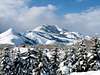
Morning light on Griffin Butte above Sun Valley.

Though not high in elevation for central Idaho, Griffin Butte stands out in beauty as well as geographical importance. Standing hundreds of feet higher than surrounding mountains, this butte is just one of the mountains that forms the breathtaking backdrop to the Ketchum and Sun Valley area. Located in the Smoky Mountains, Griffin Butte features massive south facing cliffs, more than a half mile long summit ridge, and deep forested chutes on all sides. This is a very steep mountain from any approach.
Man local hikers enjoy the various hiking trails that encircle the entire mountain, but few go out of their way to scramble to the top, as the main route contains one very steep and slippery gully.
A note of interest being that the summit of this mountain anything but butte-like, leaving its name "Griffin Butte", a mystery to me.
 |  |  |  |
Getting There
Access to this mountain is in tip-top shape. From Ketchum, drive north of Highway 75 for 1.6 miles. Here you will see a turn off to the left for Adams Gulch Road. Wind your way through the neighborhood of mansions until coming to a three-way intersection. Go left here and follow this road till it turns dirt. Shortly after, you reach a large, and very popular, trailhead parking spot. Park here and take the trail that begins to lead onto the south facing slopes of the canyon. You are now on the Adams Gulch High Trail. Ignore the first trail that leads off to your right shortly after you begin hiking. Go a little less than half a mile up and down through the Aspens until a more pronounced trail leads up a gulch to your right. This trail is marked and is your exit. Hik a little more than half a mile up the switchbacks until you reach the 6,800' contour line. From here, leave the trail and head due north until gaining the south ridge. Follow this obstacle-free ridge until below the massive south facing rocks at about 7,800' to 8,000'. To the left of the largest rock is a small gully that leads up the western side of the cliffs. This gully is very slick and steep (class 3), only one person at a time should climb it. Once at the top, continue northward on the thin ridge, to the summit, which is directly in the center of the summit ridge. From here you will enjoy unparalled views of the Sun Valley/Ketchum area.
 |  |
Red Tape
A sign at the trailhead says a test fee program is in affect. I have parked here hundreds of times and never gotten any fines. The "test" fee, means they will only give you a warning anyway.
When To Climb
Due to wonderful access year-round access, Griffin Butte may be climbed any month of the year. I am not aware of any winter ascents but they are possible. Otherwise, because of the main route's prime southerly exposure, Griffin Butte may be climbed much earlier in the year than its neighbor Idaho mountains.
Camping
Due to its close proximity to the resort towns of Ketchum and Sun Valley, there are no campgrounds in the vicinity. Though you could camp somewhere along the trail, many hotels are only 1 mile away in Ketchum.
Mountain Conditions
Being only a few miles north of Ketchum, this website will give you a good idea for what to expect weatherwise. SV Weather