
-
 26158 Hits
-
 89.91% Score
-
 32 Votes
|
|
Mountain/Rock |
|---|---|
|
|
44.09350°N / 114.9967°W |
|
|
Custer |
|
|
Hiking, Mountaineering, Mixed, Scrambling |
|
|
10353 ft / 3156 m |
|
|
Overview
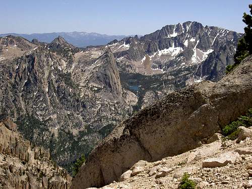
Braxon Peak lies hidden in the heart of the rugged Sawtooth Mountains in central Idaho. It has been called the summit with the most comprehensive view of the range.
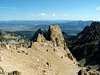
Although Braxon Peak is centrally located in the Sawtooth Moutains, this mountain is quite unique to the area. While most Sawtooth summits are composed of solid granite and slabs of flawless rock, the summit of Braxon Peak is made of crumbling sandstone-like material.
The slopes surrounding it are made up of numerous, unnamed and unnclimbed spires and towers. The unique color of rock, as well as the rare crystals, which can be found in the area, certainly make this a special mountain.
Braxon Peak is rarely climbed. It's close proximity to the Elephants Perch, Mount Heyburn, The Grand Mogul, as well as several other popular climbing areas, creates a tendency for climbers to bypass Braxon Peak. In fact, there is no rock cairn on the summit, which truly paints a picture for how seldom climbed the peak is.
There is only one known route to the summit, and because of the nature of the rock, it may be the only route as well.
 |  |
Getting There
To access Braxon Peak from Ketchum and Sun Valley Idaho, drive north on Highway 75 over Galena Summit and into the Sawtooth Valley.Drive to the obvious turnoff for Redfish Lake, just a few miles before Stanley, and follow the signs that lead you to the main lodge.
From Redfish Lake Lodge, take the transfer boat to the far end of the lake. These small boats run from 7a.m. to 5.p.m. roughly every two hours. Check for a schedule once you arrive. Otherwise it is a 5 miles hike around the massive lake.

 |  |
Routes
The main route is the East Ridge that starts from Redfish Creek. See the East Ridge Route page for more details.Red Tape
Braxon Peak is located in the Sawtooth Wilderness Area. |  |
When To Climb
A winter descent would be quite difficult as access would surely be an issue as well as avalanche danger on the approach through the unnamed drainage.The East Ridge Route is usually snow free roughly from mid July through September.
Camping
The Redfish Lake area may be the camping capital of Idaho. There are many campgrounds and camping opportunities in the area. The Redfish Lodge Website gives a complete list of CGs and explanation of the area, as well as offers cabins over night.As for camping near Braxon, there is plenty of room to plop down a tent at the base of the peak at the unnamed lakes.
Mountain Conditions
This is real rugged and remote terrain. Any sort of weather is possible year-round in the Sawtooth Mountains. There has been snow reported in every month at the higher elevations.A good idea for mountain conditions can be found on these sites
sjaxon16 - Aug 20, 2016 12:20 pm - Voted 1/10
RouteTo get to the Base of Braxon, you take the Redfish Lake Lodge shuttle across the Lake or hike the 5 miles around. From the trailhead you hike about 2 miles. When you cross over the 2nd foot bridge on the trail you take a right towards the sawtooth super slabs. There is a faded trail in the beginning to follow up. The trail will take you up the right side of the super slabs. When you get to the top of the super slabs, from the trail to take a left ad head North West across the top part of the slabs. The rail eventually fades away for good after a mile or so. Keep following along the top of the slabs until you come across a drainage with large and massive boulders. Turn up this drainage and find your way through the boulder. When you get to the top you will have reached the base of Braxon along with a couple of lakes that sit at the base. When at the base, go up the right side of braxon (North East) towards its ridge. From the ridge you follow it up right towards the peak. Going left (West side of braxon) you will find yourself in a very technical climb that can easily result in you getting cliffed out or following a very exposed class 4 ridge to the peak.
wyatt_meyers - Jul 23, 2020 2:51 pm - Hasn't voted
In depth description of the routeOnce you cross the two long bridges continue to the single short wooden bridge. Once you pass the elephants perch turn off (river crossing on the left) the trail takes a sharp right just after this and this is where you leave the trail to avoid thick brush. There was some tracks but don't expect an obvious trail like some people say. If you hit a large rock with water pouring down it (or water marks) this is not the super slabs. There is thick brush to the right of this water fall rock and is not the right way, go to the left of this rock, there is no need for bushwacking on the correct route. Once you find the super slabs on through the forest to the west (easy looking rock climbing slabs) stay to the right (northwest) of them. From leaving the trail to the base of the slabs takes 10-20 min and they will be about 300 ft uphill. The slabs are easy to follow along the right (northwest) all the way to the top and lightly traveled. From the top head left (south) across the top of the slabs until you hit a boulder field. Go to the far end and to the right (west) you'll see the easy boulder field chute with sharp peaks along both sides to the two small base lakes (seen on the map and google maps with your location on). If you pass the boulder field and hit thick bushes you passed the chute. The base lakes are the two small lakes to the southeast of Braxon. From the upper base lake we went left to the middle of the ridge and found a good chute to the top. Our friend stayed low to the right and found another relatively easy chute on the lower end of the ridge. straightforward walk up to the top after that. I'll add some pictures when I figure out how on mobile so no one gets lost again!