
|
|
Mountain/Rock |
|---|---|
|
|
35.88600°N / 81.8845°W |
|
|
Hiking, Trad Climbing, Sport Climbing |
|
|
Spring, Summer, Fall, Winter |
|
|
4100 ft / 1250 m |
|
|
Overview
Table rock is probably the most impressive rock formation in the east rim of the Linville Gorge area. If you come from the south it’s a table shaped tall rock cliff, from the north it looks like a triangle sitting above the endless forest of North Carolina’s foothills. The peak of Table rock rises into the horizon even seen from the town of Blowing Rock 20 miles away.
Table Rock offers excellent rock climbing on its vertical walls with easy access by vehicle from the forest road. The approach to the routes on the south wall are just minutes from the Table Rock parking lot.
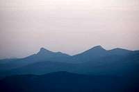 Table Rock (l)
Getting There
Take N.C. 181, coming from the north about 3 miles past the intersection with N.C. turn right into Ginger Cake Road. There is a big sign from the forest service indicating 9 miles to the Table Rock parking lot. Keep on holding to the left on Ginger Cake road and after 2 miles the road turns into a gravel surface forest road. Stay on that road for about 5 miles till you see the sign to Table Rock parking lot again (gate). Turn to the right and the gravel road will go back to pavement again. The last mile to the parking lot is very steep and the road winds below Table Rock through plenty of tight switchbacks.
If you come from the south, it is a better idea to drive all the way up on N.C. 181 and access Table Rock from Ginger Cake Road. It is possible to take a gravel surface forest road from below, but this road is very rough and about 13 miles long to the intersection of the parking lot road.
No 4wheel drive necessary. – The gate is closed in the winter month from January 1st to March 31st.
Red Tape
Table Rock is located in the Pisgah National forest and borders to the Linville Gorge Wilderness. Forest service laws and rules apply.
Some Hiking trails are within the Wilderness Area (Spence Ridge trail, Little Table Rock trail) – Wilderness regulations apply.
Climbing Routes (most important)
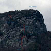
The Cave Route
Cracker Jack – 5.8
Peek-a-Boo – 5.5
Peek-a-Boo, direct – 5.10
Cave Route – 5.5
Jim Dandy – 5.4
The Peak
Hiking Trails
(1) From the parking lot it’s about a 45 minute hike to the top of Table Rock.
(2) There is Spence Ridge Trailhead about 3 miles past Ginger Cake Road. If you turn immediately left, even before setting foot on the marked Spence ridge trail, on an old abandoned forest road, follow it for about 1 mile and take the right fork uphill to get into the gap between Table Rock and Little Table Rock.
(3) Combine parts of Spence Ridge Trail and Little Table Rock trail with the trail #(2) for a nice loop.
When To Climb And Hike
Table Rock is accessible all year. The spring and fall month are the best month due to relatively low humidity.
The gate is closed from January 1st to March 31st. But you can park your car and hike up to the Rocks.
Online Resources
Weather
US Forest Service, Pisgah National Forest
Wayne Busch south-east climbing page
Books & Maps
Randy Johnson Hiking Guides
A great collection of guidebooks is found here