
|
|
Mountain/Rock |
|---|---|
|
|
19.51400°N / 103.62°W |
|
|
Mixed |
|
|
Spring, Fall, Winter |
|
|
12598 ft / 3840 m |
|
|
Overview
A short page on Mexico's most active volcano, known also as Volcán de Fuego, which sits on the border of the states of Colima and Jalisco. Only 4000 years in existence, this geological baby is growing in one of several calderas in the Colima Volcanic complex (see map below), all sitting pretty on the Pacific coast. The city of Colima, only 30km distant, is built upon a 2500 year old debris avalanche from the volcano's south flank, and still receives ash fall if wind conditions are right. Typically violently exploding several times a day and/or oozing out lava domes and flows this is a very temperamental beastie, displaying a range of styles from Strombolian to Plinian. Between explosions bouts of degassing and vigorous fumarolic activity can take place. Clearest views are during the dry season, November - April while heavy rains the rest of the year cause mass erosion and redistribution of erupted material during lahars (volcanic mud flows). Incision caused by these lahars can quickly fill up again with pyroclastic flow deposits. Plenty of photos with coordinates to show you what things are like on the volcano but overall this page has relatively little information on access to the summit as it's pretty dangerous, has an exclusion zone around it, plus the monitoring staff and civil protection guys would get upset. Similar volcanoes to Colima include Santiaguito, Reventador, Karymsky and Sakurajima (to varying degrees).  Explosion from S Explosion from S |
 View from W View from W |
 View from SE View from SE |
 View from NNE View from NNE |
Each of the large ravines ('barranca') has its own name. These include Montegrande, San Antonio, La Lumbre, La Arena, and Del Muerte. The flat open area between Colima's cone and the caldera wall of Nevado is called 'El Playon'. The area was filled in by pyroclastic flows from a succession of large historic eruptions. More recently the area has been peppered by volcanic bombs and intruded by lava flows.
View Larger Map (if no image above, right-click area and refresh)
Getting There
 View from Colima
 View from Nevado
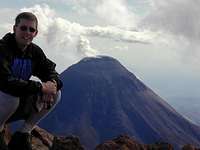
Colima isn't very well known within Mexico let alone outside it. It has its own airport, and there are other transportation hubs in nearby Manzanillo and Guadalajara. From there it's by any number of bus incarnations. ETN do a mean ham, cheese and jalapeno sandwich. Mexico City on the other hand is an option but a long 10 hours away. Other nearby towns include Comala and Ciudad Guzman with can get ashed upon even many kms away. Unfortunately for any summit baggers, on top of the rather large exclusion zone, general access is virtually not existent, you can't drive up it like Mauna Loa nor sit around at the top and watch it explode like Stromboli. The lower flanks are largely covered with private farmland where visitors might be unwelcome. Best (more or less safe, though don't hold me to that) views are from the 6km distant Nevado de Colima.
Red Tape
 Unhelpful hazard sign
As mentioned above, it's covered in the stuff, for good reason. Beyond the volcanic hazard and the private land, the local conditions can be dangerous for the inexperienced and experienced alike. One must contend with ash infested jungles, cacti for handholds, and half a dozen kinds of unstable ankle breaking ground. Ropes aren't really much good, there's not a lot you can tie one to that won't shift when weight is applied. Routes open one morning may well have turned into lahars by the afternoon. Get hurt and rescuers will have a hell of a time finding or getting to you. Scientists do go to the summit on occasion but they know what they're doing. Your best bet is to befriend one, ideally with mention that you have a helicopter or light aircraft which you would like to donate to the monitoring effort.
Risk of death in summiting at present? Not all that high, dome growth has slowed with few if any explosions. Risk of death in general, fair to middling. Being halfway up the cone and having an avalanche in your face wouldn't be pretty. Not to mention that this thing has had major eruptions with almost no warning and could kill you several miles away if not 10s of miles away. See links at the bottom for the most up-to-date info.
Video of dome in the summit crater by the meganew03 channel on youtube from October 2010.
5 mins as part of a documentary showing more recent growth of the dome (In French) also on youtube.
Types of activity
Illustrations of range of activity at Volcán de Colima and some of the eruptive products. Lahars also occur but generally only during the wet season. Lava domes additionally form from time to time, either as short term or long term features. Plinian sized eruptions (read: mass destruction) have occurred in 1913 and 1889 and 1818 as well as in previous centuries. The volcano can sometimes go for many years with little or no activity however. The current eruptive sequence began in 1994 after a 3 year hiatus.  Large explosions Large explosions |
 Mid size explosions Mid size explosions |
 Small explosions Small explosions |
 Degassing and domes Degassing and domes |
 Fumaroles Fumaroles |
 Lava flows Lava flows |
 Volcanic bombs Volcanic bombs |
 Pyroclastic flows Pyroclastic flows |
 Dead trees Dead trees |
 Ash and lapilli fall Ash and lapilli fall |
Video of some of the larger explosions from 2005 including pyroclastic flows, by Victor Vargas. Unfortunately the audio's gone but still pretty good.
Life on the Volcano
While Volcán de Colima may technically be off limits to most, as someone doing volcanological research I had the opportunity to see the terrain. Some examples of the different areas of the volcano are shown below.  Upper south side Upper south side |
 Between Nevado and Colima Between Nevado and Colima |
 Upper north side Upper north side |
 The easy way The easy way |
 The hard way The hard way |
 The cross your fingers way The cross your fingers way |
Camping and wildlife
Camping is fairly risky business - always the chance of your tent catching fire as lapilli comes down or trampled as cows go for a random stampede. Death also common from chigga dermatitis - i.e. scratching yourself to death, not to mention dehydration, pointy animals, lahars, rockfalls, the odd pyroclastic flow, and general impossibility to rescue you.Numerous types of birds and animals can be observed at Volcan de Colima. Cows and horses perhaps are the most common, with several lizard species, scorpions and rattle snakes also sometimes seen. Humming birds and vultures are both common sights, as are dead armadillos. Not being natural climbers, once they fall into a barranca they tend to have trouble getting out of them. Puma and coyote tracks are frequent sights, the pumas themselves are a bit harder to catch though sometimes you'll find yourself face to face with them. Insects, especially of the blood drawing biting kind are limitless. And of course bobcats, this is a great journal article about them. Read on!
 Dead something Dead something |
 Giant beasty Giant beasty |
 Armadillo Armadillo |
 Mystery bugs Mystery bugs |
Weather

Weather is important not just from a comfort point of view but also from a safety point of view. Rain can lead to lahars and clouds can mask eruption hazards.
Wet season character - Reliable in an unreliable sort of way. Ignore forecasts and just expect rain and possibly lightning, and lots of it in the afternoons. Wind direction usually to the west, this has a very strong influence on ash distribution. Unlikely to see the volcano at all from distance between 11am and 5pm. 4000 m of volcano behind some of the biggest clouds you've ever seen.
Dry season character - Reliable in a reliable way. Rain is extremely rare, occurring maybe only once a month if that. January is more prone and snow may cap the volcano at this time. Night temperatures noticeably colder, possibly to -15 C at 4000 m at night regionally. Wind chill can be exceptional as the location is close to the coast and nothing else as high for a very long way. Wind direction usually to the north east.
Current activty links
GVP page with general information, historical and current activity reports.
Centre of Exchange and Research in Volcanology at the University of Colima, probably the most up-to-date resource.
UNAM Colima database (Similar to GVP with videos)
Current seismicity records (is it just me or don't these actually open anything?)
Webcam images (supposedly at least)
gimpilator - Apr 20, 2017 8:49 pm - Hasn't voted
Didn't climb it, but did watch it erupt