
|
|
Mountain/Rock |
|---|---|
|
|
42.26771°N / 74.10465°W |
|
|
Hiking |
|
|
Spring, Summer, Fall, Winter |
|
|
3940 ft / 1201 m |
|
|
Overview
Blackhead Mountain is the eastern most peak of the Blackhead range. It is tied for 4th place in order of height along with Thomas Cole in the Catskill Mountains. Thomas Cole has the historic name, but Blackhead has the views.The summit of Blackhead marks the highest point on the Escarpment Trail. This trail traverses along the northern part of the Catskill "Escarpment" with numerous views of the valley 2500 feet below, including the hudson River as well as the Taconic and Green Mountains. The Escarpment trail has played an important part in America's history as it was one of the first marked hiking trails that were used solely for the purpose of enjoying nature. The early sections of this trail were being used in 1825. This is 84 years before the Long Trail and 97 years before the Appalachian trail.
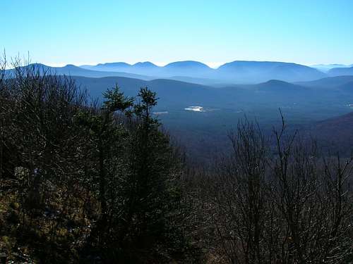
 Viewpoint East from the Escarpment trail. Click on picture for description.
The summit itself has no views, but hike a short distance to the east or west on the trail and great views are to be had. To the east, there is a small rock outcropping that peers down over the Hudson river in the distance with the Taconic Range defining the distant skyline. To the west is another outcropping with great views of close neighbor, Black Dome, the entire Indian Head Range, as well as Kaaterskill High Peak, Hunter, West Kill and the Slide Mountain area.
 The Western viewpoint. Click on picture for mountain names.
Getting There
There are two trailheads in this area with acces to Blackhead.-The Big Hollow Parking Area/Trailhead is the closest acces to Blackhead.
-The Barnum Road Trailhead is approximatly 5 miles away from the Big Hollow TH by way of road and can be easily found by using the maps by the New York/New Jersey Trail Conference.
Trails
 Map of the hike described here.
For further details on this area & trails, a copy of the Catskill Mountain Guide by Peter W. Kick, an Appalachian Mountain Club book, would be an excellent resource.
There are two ways to reach the Blackhead summit from the Big Hollow Trailhead. Both are approximatly 2.5 miles & 1740' elevation gain (one way) but one is steeper than the other.
I will explain these trails as a loop hike ascending the class 2 trail and descending the class 1.
From the Big Hollow trailhead walk to the end of Big Hollow Road, follow the Blackhead range trail (red markers) for 1/2 mi. and bear left onto the Batavia Kill Trail (yellow markers). At .25 mi. on this trail the Batavia Kill lean-to is reached and at .95 mi. make a right onto the Escarpment Trail (blue markers).
From here the trail steepens and some short, fun class 2 areas are traversed, passing a good viewpoint to the east overlooking the Hudson River with the Taconic & Green mountains on the distant horizon.
After 1 mile on the Escarpment trail, the summit is reached. Turning right (west) at this juntion, the gentle descent begins, passing the excellent western viewpoint and reaching the notch between Blackhead and Black Dome at .6 mi. From this notch, turn right onto the Blackhead Range trail (the same trail you turned off of before) and this will lead back to the Big Hollow parking area.
This is just one example hike that can be done in this area. By using the maps and book suggested earlier, one can hike a number of summits all with great views.
Camping
The Batavia Kill Lean-To mentioned earlier is the only organized camping in this region.See red tape below for backcountry camping regulations
Red Tape & Backcountry Camping
If camping in the wilderness, these regulations are to be followed:For backcountry camping permits (when neccesary, see below) visit the DEC website under services.
-Pack it in-pack it out
-No more than three succesive nights or more than ten nights per year can be spent in trailside lean-tos.
-A permit must be obtained from the DEC forest rangers if camping more than three succesive nights or in groups of ten or more. No permits will be issued to anyone under the age of 18.
-The DEC may take down & remove any tent or camping structure that is left alone for more than 48 hours
-No camping above 3500' between March 22 and December 20.
-No fires shall be left unattended
-No camping within 150 feet of any road, trail, spring, stream, or other bodies of water except in camping areas designated by the DEC.
-Rangers do Frequent these mountains.
Some Images from this area
 Green & orange, enriched by the sun, of the Batavia Kill along the Batavia Kill Trail
 Another view from the western viewpoint
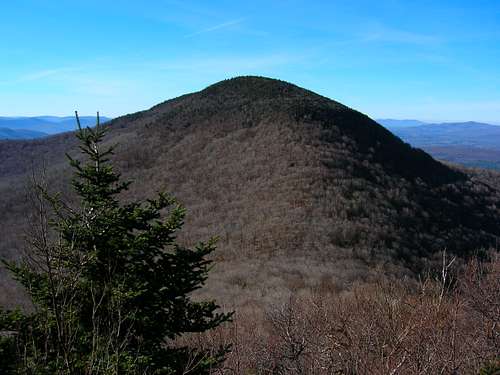 Black Dome as seen from Blackhead