
|
|
Mountain/Rock |
|---|---|
|
|
41.65780°N / 118.731°W |
|
|
Humboldt |
|
|
Hiking |
|
|
Spring, Summer, Fall |
|
|
9428 ft / 2874 m |
|
|

Overview
Duffer Peak at 9428 feet is the highest peak in northwestern Nevada. It tops the Pine Forest Range and ranks as the 22nd highest prominence peak in the Nevada top 100.
Located near the Oregon border, Duffer Peak is in a very isolated area with the nearest town of any size being Winnemucca, over a hundred miles away. It is best to make sure you have plenty of supplies and gasoline as the gas station at Denio isn't that dependable for always having gas available. If not, Fields Oregon, 24 miles north of Denio generally has gas and also has a small cafe and a marginal store.
Duffer Peak is a beautiful peak and in late May is often the only peak in the area with snow on it. It is also one of the last peaks in Nevada known to have had glaciers on it and since lakes in the great basin are rare, Duffer is blessed to have a small group of glacial carved lakes, the Blue Lakes near
its base.
Getting There
There are two ways to get to where you start this hike from, one way from the north, west of Denio and the other way from highway 140 south of Denio. As I only have experience with the northerly approach, I will not be able to provide info on the eastern approach. I'll leave that to someone else. I do know that some consider it a nasty approach with drop offs and a narrow road. So, for the northern approach, west of Denio, here it goes: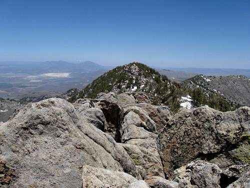
Heading north from Winnemucca on U.S. 95, take a left about 30 miles out of town onto Nevada highway 140. The first sign will tell you that you have 66 miles to go to reach Denio, which is the first gas (when available) you will
see. Also a small cafe and minimal store and motel is to be found at Denio but not much else. Continue past Denio by taking 140 as it turns left and go another ten miles to the Knott Creek road which goes south on a well graded dirt road. Watch for wild burros along this stretch, we saw quite a few. Go for 9 miles until you reach Gridley Lake, an unsigned road (shown as 2083 on Benchmark) will head uphill to the left (east) and you will know you are on the right road when you see a vault toilet within the first mile. Why it is there is anyone's guess but most likely it is for hunters.
Continue on past this structure and follow the road as it takes some ups and downs but generally ups as it heads southeast until it crests a small divide after making some twists and turns to do so. Watch for cattle along the way. When a valley opens up before you, the road continues on to the south but look for a turn that goes left downhill into the valley. Before you descend this steep road which hooks back to the left, look for a road on the other side of the valley that is ascending the opposite hillside. That is the road you will need to be on.
After the descent, you will cross a small stream and then take the first left. After a short distance, a road to the right takes off uphill (the one you saw earlier) and ascends steeply gaining a lot of elevation, finally reaching an overlook of the Onion Valley reservoir. The road then drops to the reservoir and go towards the little picnic/camping area that curiously has two vault toilets. Note some tables as well but look for a rough road that goes uphill from there and will take you to Little Onion Lake.
At Little Onion Lake, stay left and look for the metal roofed shack where many people will park. If you have 4X4 with high clearance, you can go past the shack and beyond on a very rough road that will take you 1.3 miles further and higher. Where a large sign indicates no further motor vehicle travel, a trail takes off that will lead you to Duffer Peak.
It is over 20 miles from the highway (140) to the end of the road. A BLM map would be helpful. I'll see about adding a map of my own in the near future. 4X4 with high clearance strongly recommended.
Red Tape
Located on BLM land, there is not much in the way of red tape. More information can be requested from the BLM office in Winnemucca at:5100 E. Winnemucca Blvd.
Winnemucca, Nevada 89445
This BLM office has this to say about the area that Duffer Peak is located:
Pine Forest Recreation Area
"There are three popular recreation sites within the Pine Forest Recreation Area. Blue Lakes, Onion Reservoir, and Knott Creek Reservoir. All three have superb scenery, excellent fishing, hunting, wildlife viewing, primitive camping, mountain biking, and opportunities for photography exist at every turn. This is a remote area, with dirt roads. Bring extra food and water. Four-wheel drive vehicles are advised. The roads are passable only in dry weather."
Leave No Trace (click for informational link)
Camping
Camping is permitted on BLM land (see the Leave No Trace link above).
You will pass this spot on the way to the trailhead: (see pic)
Onion Valley Reservoir – 28 miles south of Denio Junction. Six semi-primitive campsites for tents or tent
trailers, two vault toilets, fire grills, tables, no fee. Accessible mid-June through mid October. (note: It was accessible in 2009 in Mid May)
Weather

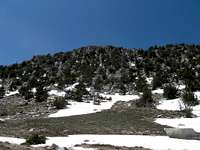
 Caleb's pic of Duffer from afar.
 Route
Rather than post a separate route page, I'll do my best to relay how we accessed this peak from the trailhead. Others have gone straight up from the rancher's shack at Little Onion lake BUT:If you want to actually save time and avoid bushwhacking, head up the road from just beyond (walk or drive it) a distance of 1.3 miles.
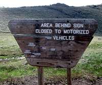
Once you get to the end of this road, you will see a large sign warning against off road activity
GPS 41.6738 -118.76615 at 7600'
Back of this sign you will see a trail cutting up the slope and this is the trail you need to get on. Look for a trail cutting up the side of the hill that is behind the sign. That is the trail you will take.
This is at an elevation of 7600 feet and while the trail disappears in a mile or so, you can easily work your way cross country past a couple other meadows and tree areas (and some brush)to Outlaw and Hidden Meadows.
Hidden Meadows: 41.6680 -118.7291 8250. Beyond Hidden Meadows, go uphill to a draw and at the top of the draw, go to the right and head up for Bare Pass at 9050 feet. You can aim for the south summit from any point along the way, using your cross country skills to guide you. Or you can go directly up from Bare Pass to the summit although I would suggest you have a gps waypoint of the summit so you can "aim" for it.
Round trip: 8 miles Elevation gain: close to 2000 feet (includes ups and downs)
Three hours up and two down
The main highpoint doesn't count for the Great Basin Peak list. Read on...
What is with the Great Basin Peak list on this one? In checking that list out, I find that the north peak is what counts and not this one. What? That doesn't make any sense to me. The north peak has a prominence of 40 feet and is 28 feet lower. So if you climb the true highpoint but don't go over to the north peak, this one doesn't count for Duffer on the Great Basin list. To me, that is truly dumb. My 2cents.Bruce Grubbs guidebook
NWHikers Trip report Highly recommended.
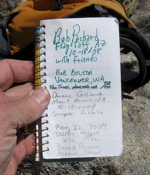
Register entry
Disclaimer
As road conditions can change and hiking or traveling in this type of country can be inherently dangerous, the above information is provided only as a courtesy. You accept all risk and responsibility for your activities in this area and I recommend that you let others know of your plans and where you will be hiking/climbing prior to heading to this area. Be self sufficient and carry plenty of food, water and shelter in the event of a breakdown. Good quality tires are suggested on the rough and rocky roads you will encounter as is a vehicle in good condition. The nearest gas is in Denio and the nearest mechanic/garage is in Winnemucca, about 100 miles away.Links
Caleb Morris - Trip reportRichard Carey - Trip report
gimpilator - Jul 18, 2016 11:39 am - Hasn't voted
Road Conditions"As road conditions can change and hiking or traveling in this type of country can be inherently dangerous, the above information is provided only as a courtesy." How true. Dean, I have an update for your road description. This road is in seriously bad shape. I'm not sure if you've heard about my recent trip or not (I emailed you), but this road was by far the worst approach road of the entire trip. I have 8.5 inches of clearance on my Subaru and we barely made it to the Onion Valley reservoir. Due to large exposed rocks and obviously new washouts, this road is now only suitable for Jeeps or trucks. Interestingly Google Maps shows a different road coming in from the east side and Theodore Basin (41.720759, -118.682005) and I suspect this might now be a better way to drive in. But who knows until someone tries it, right?