

-
 61779 Hits
-
 85.36% Score
-
 20 Votes
|
|
Mountain/Rock |
|---|---|
|
|
35.70531°N / 83.25768°W |
|
|
Haywood |
|
|
Hiking |
|
|
Spring, Summer, Fall, Winter |
|
|
6621 ft / 2018 m |
|
|
Overview
Mount Guyot is the second highest peak in Great Smoky Mountains National Park. It is also:
- The 3rd highest peak in the eastern United States*
- The 4th highest named peak in the Appalachian Range
- The highest peak in the eastern U.S. that is more than a short walk from a large, paved parking lot
- The highest peak in the eastern United States without a maintained trail to the summit
*Among peaks with more than 300 feet of clean prominence; east of the Black Hills, SD.
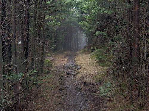
Very few people visit Guyot despite its relative status. For most AT through hikers, it is an afterthought along the way. Unlike Clingman's Dome or Mount Mitchell, it is remote and lacks spectacular summit views. The land around it was never settled or logged; even the Cherokee rarely ventured on its slopes. Old growth forest grows thick along its myriad streams and creeks; moss covers every stone. Guyot is a lonely peak in the heart of an ancient range. The summit itself is a windy, tangled mass of fallen limbs, thorny blueberry vines and dark fir trees. It is an uninviting place whose beauty lies not in aesthetics but in poetics; a timeless song of life, death, struggle and rebirth. This, to me, makes Guyot the very best of the Smoky Mountains. It is the monarch of a wilderness that remains wild and primeval. It is a fragile, beautiful peak that reminds us nothing is constant on the blue planet but change.
Old Growth Forests
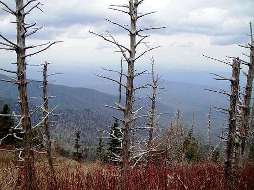
The forests surrounding Mount Guyot are notable for stands of old growth. Most of the eastern Smokies were never logged. As such, large Fraser firs, Balsam Firs, maples and alders lend an ancient beauty to the area. Sadly, many of these great trees are being killed by acid rain, nitrogen and sulfur-based pollutants caused by coal power plants, diesel and other man-made sources. They are also afflicted by insect infestation due in part to warming winter weather.
Getting To The Top
While it is possible to hike in one day, the mountain's shortest route climbs 4,000 feet in its first five miles and culminates in a bushwhack through dense forest.
There are three possible routes, which vary from 15 to 34 miles:
Newfound Gap - The "classic" route (33.6 miles RT)
Take highway 441 south of Gatlinburg, TN. From the Newfound Gap parking lot (elev. 5048 feet) head northeast on the Appalachian Trail (AT) for 15 miles to Tricorner Knob Shelter. Continue on the AT for about 1.6 miles. The trail will climb steadily until it reaches an apex and levels out. You'll know you've gone too far if the trail begins to descend to Old Black. Look for the trail's highest point and head up; the ridgeline will guide you SW to the top. The final 1/4 mile is a bushwhack that requires basic route-finding skills and a keen sense of direction. Note: Guyot has 2 summits; the highest lies about 200 yards southwest of the other. The false summit has a much steeper slope to the northeast than the real one, which slopes more gradually on both the NE and SW sides (vague, I know). There is a small gap between the two. If you find yourself in the gap, simply turn right (SW) up the ridge to the benchmark. If you find yourself in an area where the ridge line slopes up to the NE, than you are heading to the false summit. Turn around and head down (SW) to a "gap" and up to the real summit. Do not bother trying to locate a faint trail or manway. You won't find it.
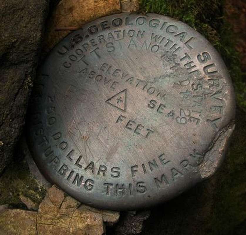
The highest point is benchmarked. There is also a small summit cairn.
Snake Den Ridge Trail - The shortest route (14.4 miles RT)
Take Highway 321 east from Gatlinburg, TN to Cosby, TN. Follow signs to Cosby Campground. The trail head lies at the southwest corner of Loop B (see the trail PDF below).
Follow the trail for 4.6 miles as it climbs steeply to Maddron Bald Trail. Turn left and continue 0.7 miles to the Appalachian Trail. Turn right at the junction and continue 1.9 miles up the slopes of Mount Guyot. You will pass a small cairn on your left, which marks the beginning of a faint manway. This does not lead to Mount Guyot, but instead takes you 100 yards to the summit of Old Black. Continue about 0.3 miles past this cairn. At the trail's highest point, simply turn left and climb to the crest of the ridge. From there, continue SW along the ridge to the summit. Note: Guyot has 2 summits; the highest lies about 200 yards southwest of the other. The false summit has a much steeper slope to the northeast than the real one, which slopes more gradually on both the NE and SW sides (vague, I know). There is a small gap between the two. If you find yourself in the gap, simply turn right (SW) up the ridge to the benchmark. If you find yourself in an area where the ridge line slopes up to the NE, than you are heading to the false summit. Turn around and head down (SW) to a "gap" and up to the real summit. Do not bother trying to locate a faint trail or manway. You won't find it.
The highest point is benchmarked. There is also a small summit cairn.
Davenport Gap - The hard way (28 miles RT)
Take I-40 east from Knoxville, TN or west from Asheville, NC. Take exit 451 south to Big Creek (past Waterville) and turn right on state road 32 (it's unpaved). Continue to Davenport Gap and the Appalachian Trail. Hike west over Mount Cammerer to Cosby Knob Shelter (7.3 miles). Continue west for another 6.6 miles, or 1.9 miles past the Maddron Bald Trail junction to the start of the bushwhack. Don't be fooled by a summit cairn and flagging tape trail on your left about 1.6 miles past the Maddron Bald junction. This marks a manway to the summit of Old Black. Continue past this to the apex of the trail high on the slopes of Mount Guyot. Note: Guyot has 2 summits; the highest lies about 200 yards southwest of the other. The false summit has a much steeper slope to the northeast than the real one, which slopes more gradually on both the NE and SW sides (vague, I know). There is a small gap between the two. If you find yourself in the gap, simply turn right (SW) up the ridge to the benchmark. If you find yourself in an area where the ridge line slopes up to the NE, than you are heading to the false summit. Turn around and head down (SW) to a "gap" and up to the real summit. Do not bother trying to locate a faint trail or manway. You won't find it.
The highest point is benchmarked. There is also a small summit cairn.
![Mount Guyot Benchmark]() Numerous other route variations exist, since any trail that intersects with the AT is a potential route. Page two of the following PDF details all nearby trails:
Numerous other route variations exist, since any trail that intersects with the AT is a potential route. Page two of the following PDF details all nearby trails:
Great Smoky Mountains Trail Map
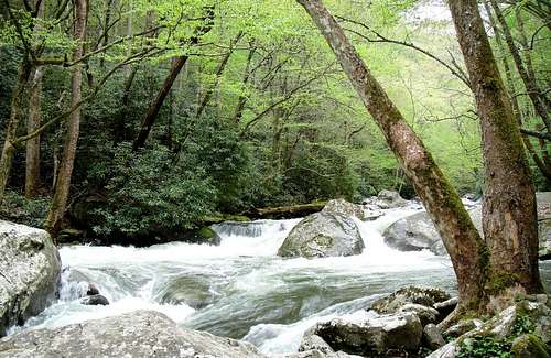
![Big Creek, North Carolina]()
A free backpacker permit is also required and can be obtained at any park ranger station or campground.
Great Smoky Mountains National Park Web Site
The Carolina Mountain Club: South Beyond 6000 in the Smokies

Want to do something? Join the Natural Resources Defense Council and tell your lawmakers to support the EPA's ability to enforce air quality.
![Acid Rain Damage]()
Great Smoky Mountains Trail Map
Red Tape
While Mount Guyot can be reached in one day, most spend the night at the Tricorner Knob or Cosby Knob shelters. A reservation is required to stay at the shelters. Simply contact the Great Smoky Mountain National Park Backcountry Reservation Office at (865) 436-1231.A free backpacker permit is also required and can be obtained at any park ranger station or campground.
Camping
Camping varies from $14 to $23 and is available after April 1st at any campground in the park. The nearest campground is Cosby. Check out a park map.Links
The Appalachian Trail Conservancy.Great Smoky Mountains National Park Web Site
The Carolina Mountain Club: South Beyond 6000 in the Smokies
Air Pollution In The Smokies
While moisture often occludes views from high Appalachian ridges, the National Park Service reports that views in the Smokies have decreased by 60 percent in the last 40 years due almost entirely to nitrogen and sulfur-based human pollutants. Coal and diesel are largely to blame. Please help preserve these views and your environment by using less electricity, especially for summer AC/cooling.Want to do something? Join the Natural Resources Defense Council and tell your lawmakers to support the EPA's ability to enforce air quality.
Eleutheros - Apr 25, 2011 6:00 am - Hasn't voted
Route InfoPosted some extra details in the "getting there" section and made one important correction to a typo... turn left instead of right to the summit when heading SW on the AT.
e-doc - May 31, 2013 7:33 am - Hasn't voted
Other routesThat are shorter are to the AT via Balsam Mountain trail and up from Round Bottom/Big Creek. Well done.