
|
|
Mountain/Rock |
|---|---|
|
|
38.67433°N / 120.08897°W |
|
|
Amador |
|
|
Hiking, Scrambling |
|
|
Summer, Fall |
|
|
9410 ft / 2868 m |
|
|
Overview
Thunder Mountain is the highest point in Amador County, California. It is located in the Sierra Nevada mountains just above the Kirkwood ski area. As a high point, it certainly does not stand out, mostly because it shares a plateau with several mountains in neighboring Alpine County that are higher.
Regardless, Thunder Mountain is a popular destination for hikers all over the region. Access is easy, with the primary trailhead right off of Highway 88. The primary trail to the summit is short (3.6 miles one way with 1600 feet of elevation gain) and relatively simple to follow. Views from the summit are spectacular.
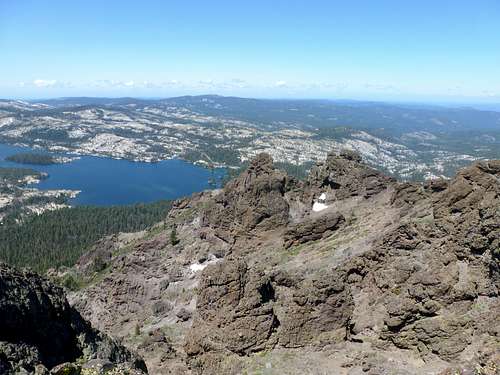 View to Silver Lake from the summit
Although not lofty at only 9410', Thunder Mountain sees plenty of snow, especially on its east side, where the Kirkwood Ski area enjoys a long ski season, typically ending in May. The best time to hike Thunder Mountain is probably late June/early July or early fall.
The actual named "Thunder Mountain" is a rock formation 2' lower than the summit. However, the highest point in Amador County is 9410' at Thunder Mountain.
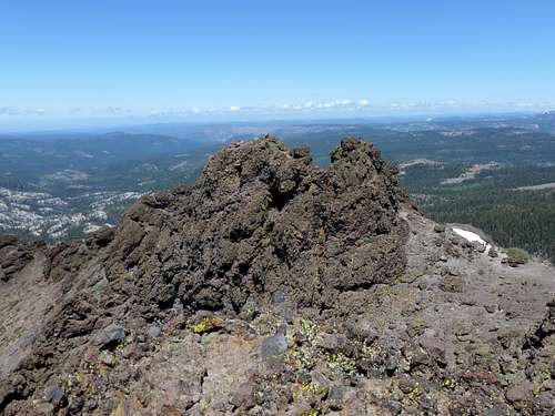 The named summit of Thunder Mountain - 2' lower than the actual summit.
Getting There
From Reno/Carson City to the north, drive south on Highway 395 to the junction with Highway 88. This will take you into California. Once on Highway 88 it is about 28 miles to Carson Pass (which is the trailhead for Round Top, Red Lake Peak, and a few other peaks in the area). Continue past Carson Pass. You will reach Kirkwood in about 5 miles. 1.7 miles past Kirkwood there is small trailhead on the left side of Highway 88. The trailhead has a sign with a trail map, and clearly marks the area as the "Thunder Mountain Trailhead".
This is the primary approach for the hike. Although, one can choose to hike the longer Thunder Mountain loop from the same trailhead or a steeper route from the Horse Canyon Trail which leads up to the southwest side of Thunder Mountain.
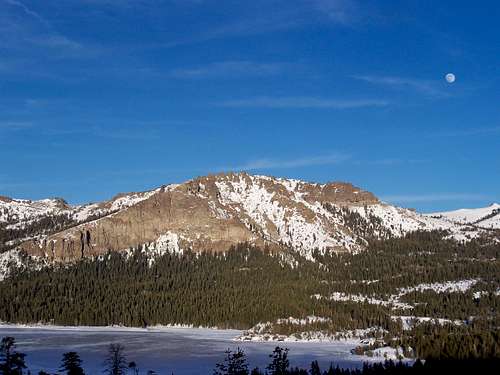 Thunder Mountain in winter - from Silver Lake
Route Information
Direct Route from Thunder Mountain Trailhead
The most direct route is to take the Thunder Mountain Trail directly south from the trailhead. The entry to the trail is clearly marked. The first mile or so is in the forest, with some viewpoints as you go further up. Soon you reach an overlook and a big rock. The trail heads uphill to the right of a rock formation and up to a saddle between Thunder Mountain 9410' and Martin Point 9250'. Once atop this saddle, the full north face of Thunder Mountain comes into view. Martin Point can be hiked via a short side trip, but it isn't actually its own peak; more like a high bump on the ridge between itself and Thunder Mountain.
Follow the trail as it heads up towards the north face. The trail crests at about 9,330' and then descends to the back side of the summit ridge. It continues up the back (south) side for a little less than 1/2 mile to the summit.
Total hiking distance one-way is about 3.6 miles with roughly 1600' of elevation gain.
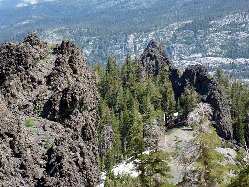 Looking back down to the trail on the way up to the saddle
Thunder Mountain Loop
Instead of taking the Thunder Mountain Trail south, you can cross Highway 88 and loop around towards Castle Point (north of Highway 88) and then descend to the Horse Canyon Trail. Cross Highway 88 and get on the trail, heading up the southwest side of Thunder Mountain. You eventually reach the summit in over 7 miles, and then return via the Thunder Mountain trail. Elevation gain is closer to 2500' via this route.
This route is covered by Mike White in his popular hiking book “Afoot and Afield Reno-Tahoe” which features Thunder Mountain and the Thunder Mountain Loop on pages 311-312 of his 2006 publication.
Horse Canyon Trail
You can also choose to park at the Horse Canyon Trailhead on the south side of Highway 88 about 2 1/2 miles or so west of the Thunder Mountain Trailhead, and east of Silver Lake. Head up the trail for about 2.2 miles where you connect to a trail on the south side of Thunder Mountain. It is about 4 miles total to the summit with an elevation gain of over 2200'.
Combination hike with Thimble Peak.
The Thunder Mountain Trail offers a combination hike with nearby Thimble Peak 9805'.
From the east side of the ridge at 9,330' described above, Thimble Peak is less than 2 miles away. Round trip, hiking both summits from the Thunder Mountain trailhead is about 10 3/4 miles with an elevation gain of 2800' on the way up both peaks. Thimble Peak can also be combined with Thunder Mountain if hiking up the Horse Canyon Trail.
Red Tape
Parking at the Thunder Mountain Trailhead requires no permits or fees. The same appears to be the case for the Horse Canyon Trailhead.
Camping
Camping information for the area is provided on the Mokelumne Wilderness SP page and others SP pages in the Mokelumne Wilderness.
External Links
Carson Pass Management Area
Mokelumne Wilderness
El Dorado National Forest Highway 88 Hiking Trails