
-
 25338 Hits
-
 91.75% Score
-
 36 Votes
|
|
Area/Range |
|---|---|
|
|
46.49000°N / 12.87000°E |
|
|
8484 ft / 2586 m |
|
|
Overview
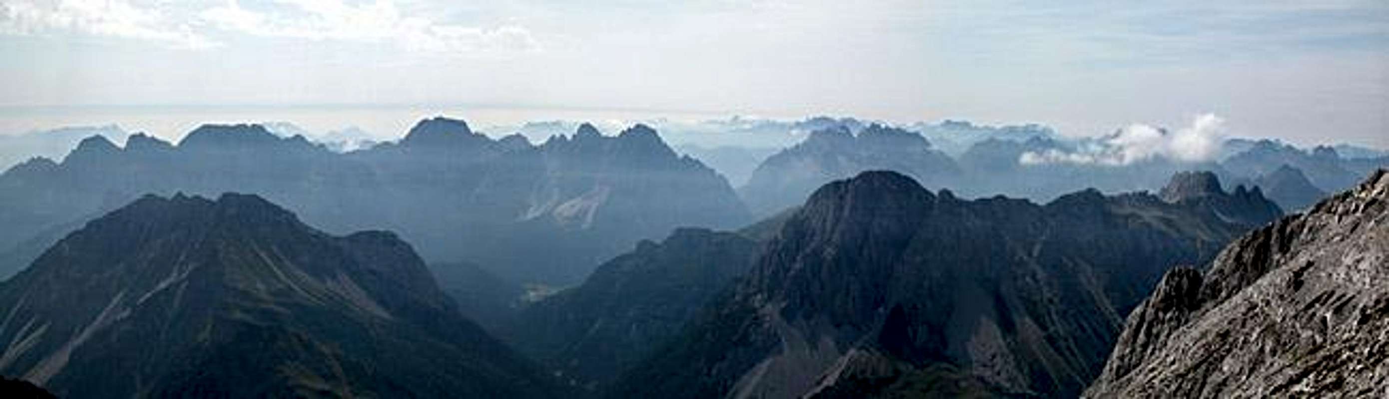
As discussed in a thread in the Europe Forum we divided the Carnic Alps Mountain Range into five subgroups. The Southern Carnic Alps Group is the fourth group to be posted to SP and is the central subgroup of the whole range. 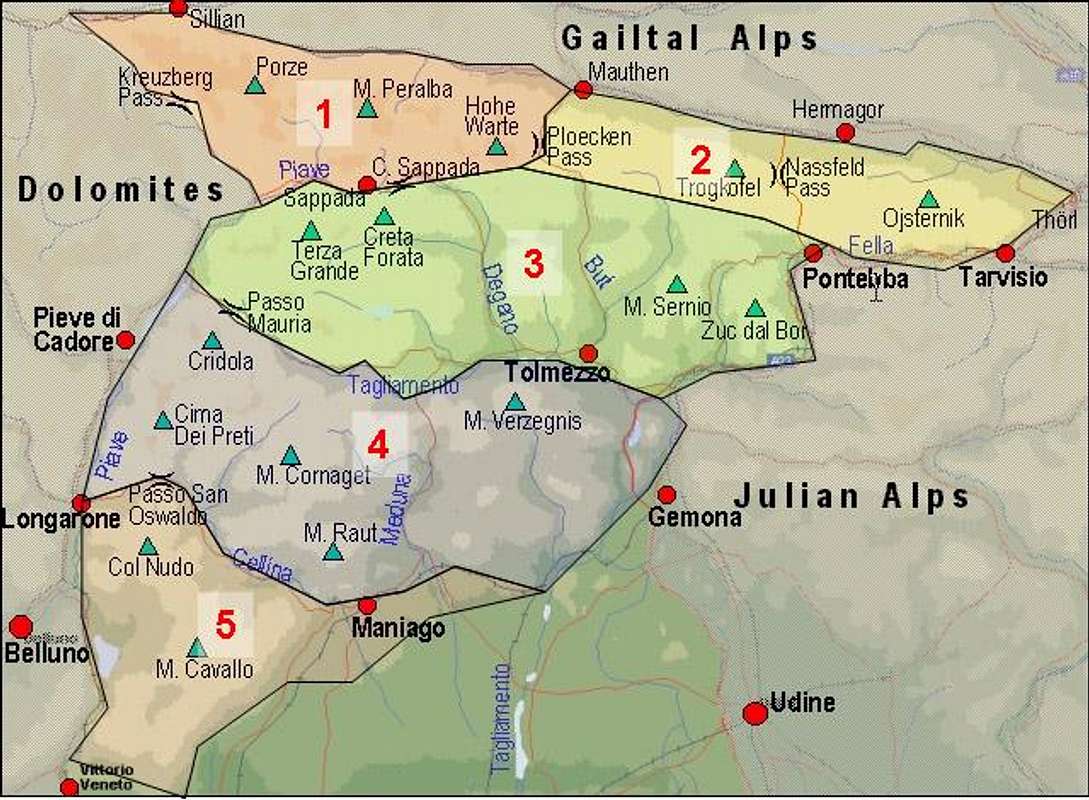
The Southern Carnic Alps on SP
  |
The Southern Carnic Alps stretch over an area of 2100 square km (70km west-east x 30km north-south) and are divided by deep valleys which separate them into no less than eight subgroups. The size and importance of these subgroups varies, however. While (as stated above) the Terze - Siera Group is very important several of the southern subgroups could be termed hills rather than mountains. Nevertheless they will be added here with the following grouping structure:
- Monte Brentoni Group
- Terze - Siera Group
- Pieltenis - Col Gentile Group
- Tiarfin - Bivera - Tinisia Group
- Arvenis Group
- Tersadia Group
- Sernio - Grauzaria Group
- Zuc dal Bor
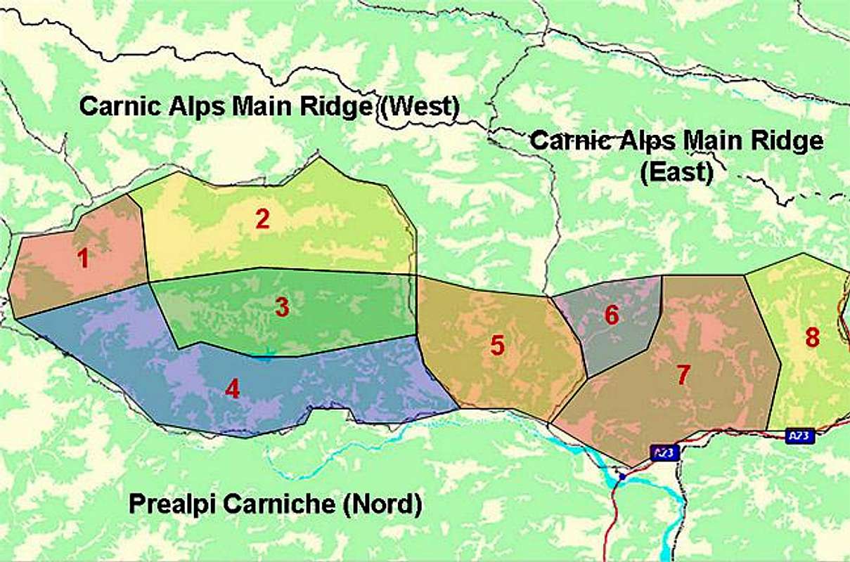
Interactive map - eastern part
Below is the interactive map - guidebook, providing a lot of information about the last 4 groups (eastern part). Click on map features and you will get them presented one by one. Red are marked routes, brown are the described non-marked routes. Other trails are embedded into the original OpenStreetMap and can be also trusted to certain degree. (Vid Pogachnik)
1 - Monte Brentoni Group
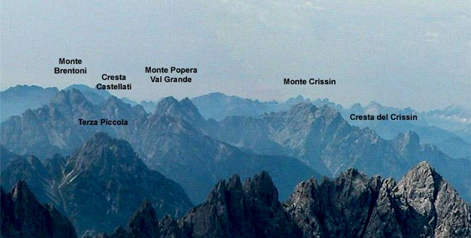
To the north-west of the mountain range you can find the Monte Brentoni Group. The highest mountain of the Group, Monte Brentoni, reaches 2548m. 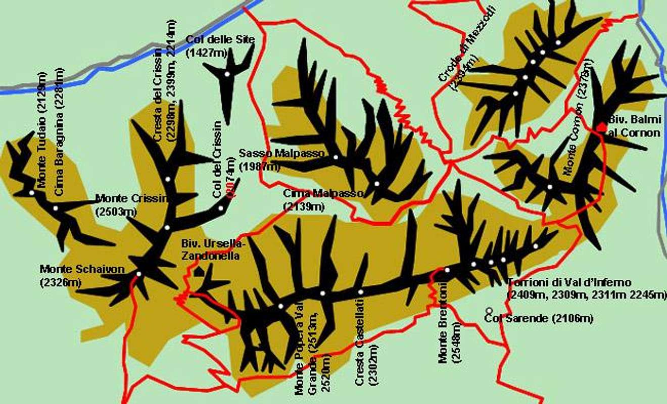
The Group is bounded by the Piave River to the north and west, Val Piova to the south and Val Frison to the east.
North-Western Ridge (west to east)
- Monte Tudaio (2129m)
- Cima Baragnina (2281m)
Monte Crissin Ridge (north to south)
- Col delle Site (1427m)
- Cresta del Crissin (2298m, 2399m, 2214m)
- Col del Crissin (2074m)
- Monte Crissin (2503m)
- Monte Schaivon (2326m)
![]()

Main Ridge (west to east)
- Monte Popera ValGrande
- Cima Ovest (2513m)
- Cima Est (2520m)
![]()
- Cresta Castellati (2302m)
![]()
- Monte Brentoni (2548m)
![]()
- Torrioni di Val d'Inferno (2409m, 2309m, 2311m 2245m)
- Monte Cornon (2378m)
- Crode di Mezzodi (2394m)
- Monte Col (2079m)


Northern Side Ridge (from Monte Brentoni)
- Cima Malpasso (2139m)
- Sasso Malpasso (1987m)
Southern Side Ridge (from Monte Brentoni)
- Col Sarende (2106m)
2 - Terze - Siera Group

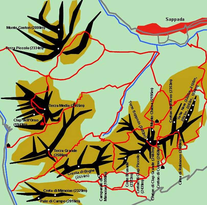
This is the most mportant of the Subgroups of the southern Carnic Alps. It can roughly be divided in two parts, the Terze subgroup to the west, separated by Passo Oberenghe from the long ridge of the Siera - Clap subgroup. All summits are off limits to the casual hiker, you need alpinistic experience to reach them. Two variants of the "Carnia Trekking Trail" cross the group from north to south on both sides of Monte Siera.
The boundaries of the subgroup are: the Piave River to the north, Val Frison to the west, Val Pesarina to the south and Val di Gorto to the east.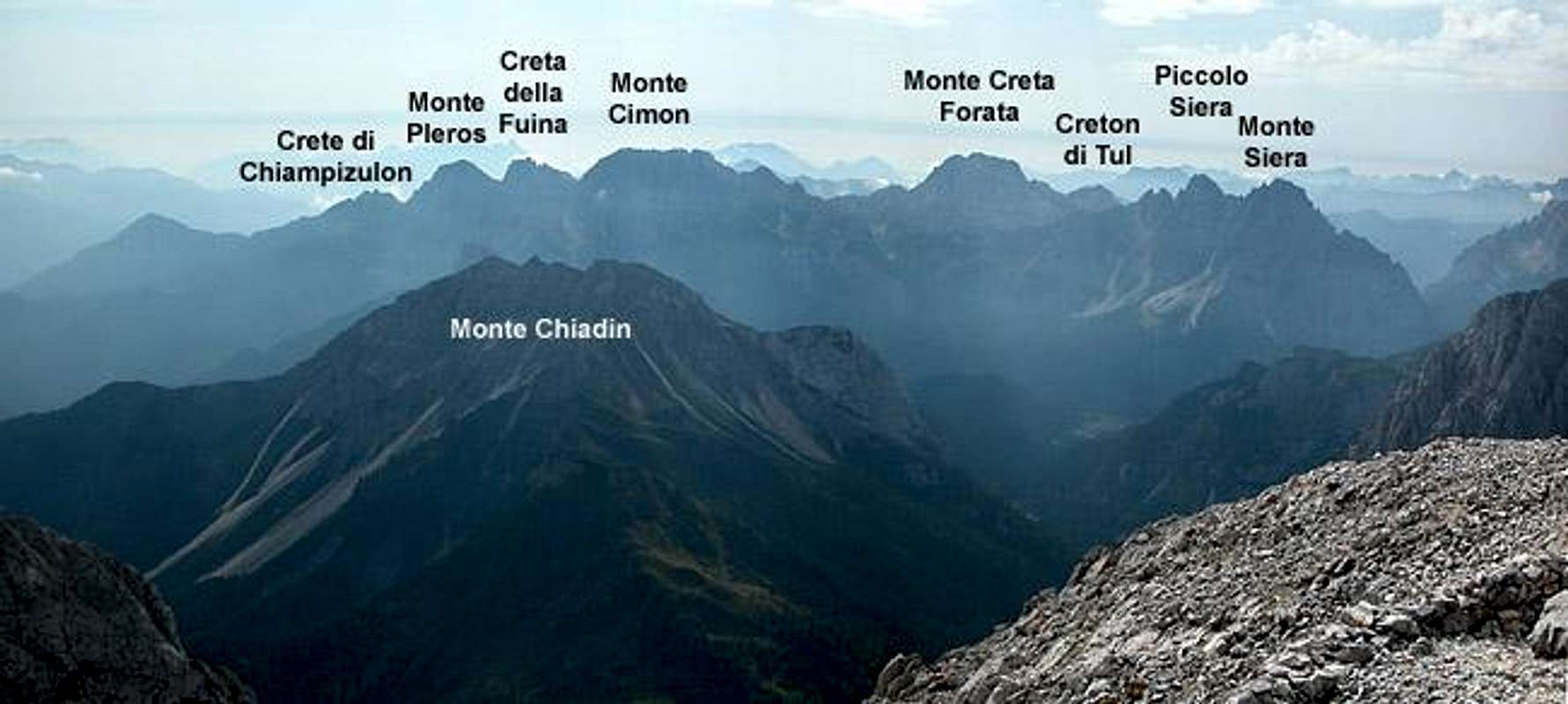
Le Terze (north to south)
- Monte Coston (2000m)
- Terza Piccola (2334m)
![]()
- Terza Media (2455m)
![]()
- Clap dell'Orso (1943m)
- Croda Casara (2372m)
- Monte Fiorto (2100m)
- Terza Grande (2586m)
![]()
- Croda Naie (2239m)


Monte Siera (west to east)
- Pale di Campo (2016m)
- Creta di Mimoias (2320m)
![]()
- Cresta di Enghe (2414m)
![]()
- Campanile di Mimoias (1998m)
- Crete Brusade (2322m)
- Creton di Clap Piccolo (2439m)
![]()
- Torre Sappada (2462m)
- Creton di Clap Grande (2487m)
![]()
- Creton di Culzei (2458m)
![]()
- Cima di Robianco (2400m)
- Monte Chiesa (2195m)
- Creton dell'Arco (2353m)
- Vette Nere (2208m, 2186m, 2091m, 2068m, 1894m)
- Col dei Mughi (1973m)
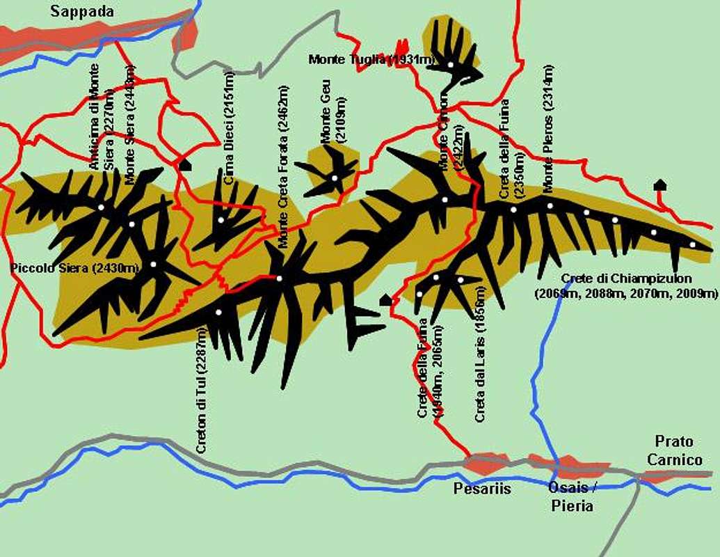
- Anticima di Monte Siera (2270m)
- Monte Siera (2443m)
![]()
- Piccolo Siera (2430m)
![]()
- Creton di Tul (2287m)
- Monte Creta Forata (2462m)
![]()
- Monte Cimon (2422m)
![]()
- Creta della Fuina (2350m)
- Monte Pleros (2314m)
- Crete di Chiampizulon (2069m, 2088m, 2070m, 2009m)


1st northern side ridge (from Clap Grande)
- Monte Hoberndeirer (2208m)
2nd northern side ridge (from Monte Siera)
- Cima Dieci (2151m)
![]()
- Cresta del Pettine (2206m, 2165m, 2049m)
- Terzi del Pra Sator (1754m, 1777m, 1947m)
- Monte Geu (2109m)
- Monte Tuglia (1931m)

Southern side Ridge (from Creta della Fuina)
- Creta dal Laris (1856m)
- Crete della Fuina (1940m, 2065m)
3 - Pieltinis -Gentile Group
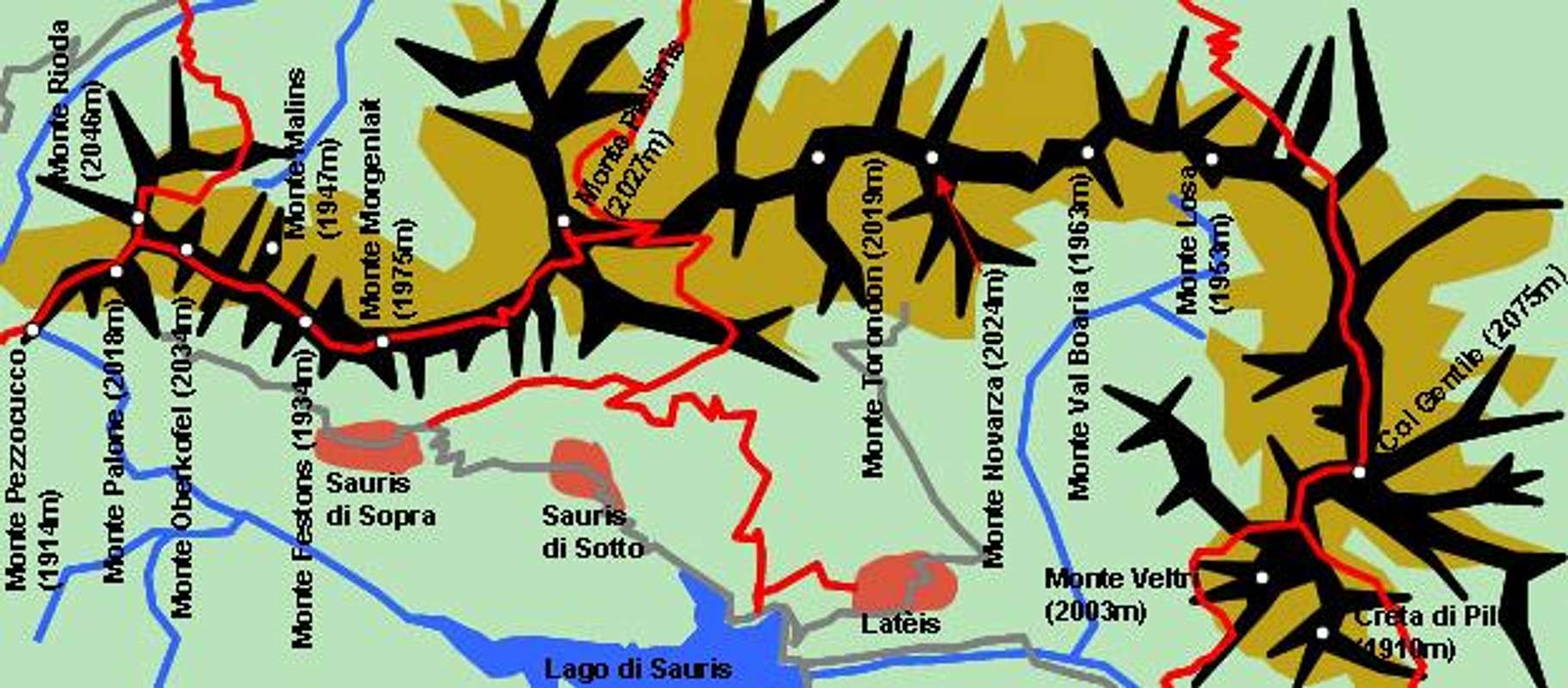
Though one of the lager subgroups the Pieltenis - Gentile Group is of no great importance alpinistically. Except for Col Gentile, which has rocky faces all the other mountains of the group have round summits which can be easily reached. Some of the few trails of the group actually run along forest roads which even reach the summit ridge. The subgroup, however, is very good for lookout-points. Much of the main ridge has an unobstructed view towards the higher and more impressive peaks of the subgroups around.
The group is bounded by Val Pesarina to the north, Sella di Rioda to the west, Val di Laur and Val del Lumei to the south and Val di Gorto to the east.
Main Ridge (west to east)
- Col di Rioda (1966m)
- Monte Pezzocucco (1914m)
- Monte Palone (2018m)
- Monte Rioda (2046m)
![]()
- Monte Oberkofel (2034m)
- Monte Festons (1934m)
- Monte Malino (1947m)
- Monte Morgenlait (1975m)
- Monte Pieltinis (2027m)
![]()
- Monte Torondón (2019m)
- Monte Novarza (2024m)
- Monte Val Boaria (1963m)
- Monte Losa (1953m)
- Col Gentile (2075m)
- Monte Veltri (2003m)
- Creta di Pil (1910m)


Side Ridges
- Col Cervera (N, 1998m)
- Monte Vinadia (N, 1843m)
- Monte Hoche Lanar (S, 1855m)
- Monte Rinder Perk (S, 1755m)
4 - Tiarfin - Bivera - Tinisa Group
This is the largest of the subgroups of the Southern Carnic Alps. It is located to the south-west and consists of three distinctive subgroups located around Monte Tiarfin in the north-west, Monte Bivera in the centre and Monte Tinisia to the south-east. On the southern slopes of Monte Tiarfin you can find a number of ski lifts, all belonging to the village of Forni di Sopra.
The group is bounded by Val Piova, Val di Laur, Val del Lumiei to the north, the Piave River to the west, the Tagliamento River to the south and Val del Lumiei to the east.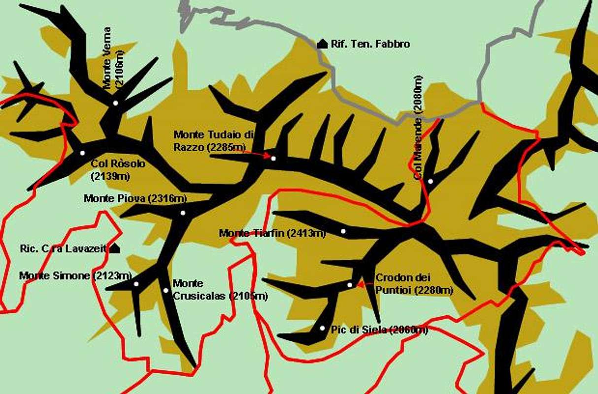
Tiarfin SubgroupMain Ridge (west to east)
- Monte Verna (2106m)
- Col Ròsolo (2139m)
- Monte Tudaio di Razzo (2285m)
- Col Merende (2080m)
1st southern side ridge
- Monte Piova (2316m)
- Monte Simone (2123m)
- Monte Crusicalas (2105m)
2nd southern side ridge
- Monte Tiarfin (2413m)
- Crodon dei Puntioi (2280m)
- Pic di Siela (2060m)
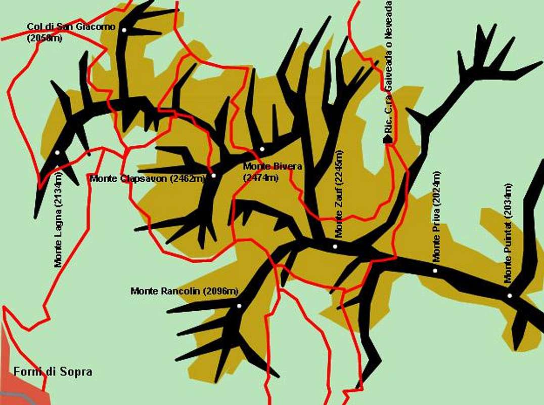
Bivera SubgroupMain Ridge (west to east)
- Monte Lagna (2134m)
- Col di San Giacomo (2058m)
- Monte Clapsavon (2462m)
![]()
- Monte Bivera (2474m)
![]()
- Monte Zauf (2245m)
- Monte Priva (2024m)
- Monte Puintat (2034m)


Southern side ridge
- Monte Rancolin (2096m)
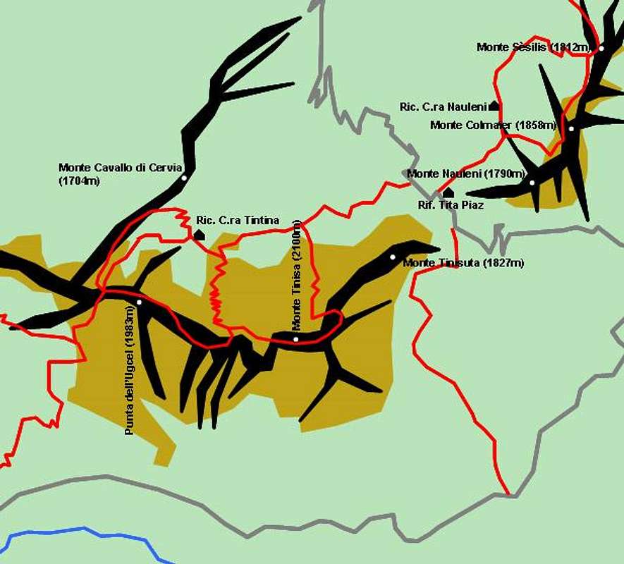
Tinisa SubgroupMain Ridge (west to east)
- Monte Cavallo di Cervia (1704m)
- Punta dell'Ugcel (1983m)
- Monte Tinisa (2100m)
- Monte Tinisuta (1827m)
- Monte Nauleni (1790m)
- Monte Colmaier (1858m)
- Monte Sèsilis (1812m)
5 - Arvenis Group
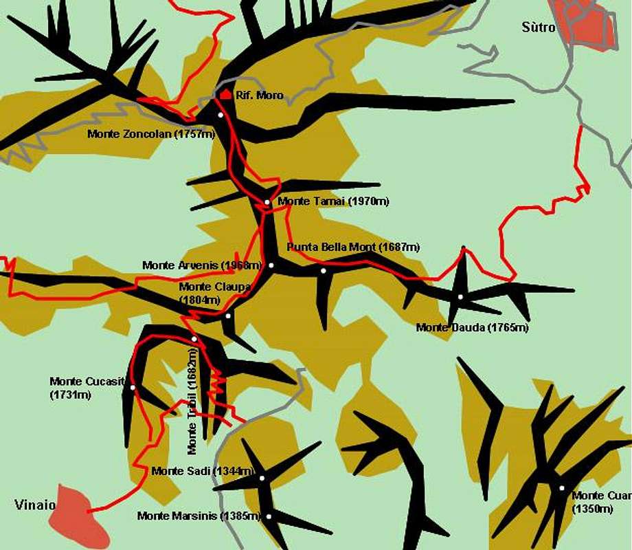
The Arvenis Subgroup is located at the centre of the southern Carnic Alps. It is, however, one of the smallest and least significant subgroups of the range. Apart from Monte Arvenis all you find are rounded hilltops. The northernmost of these, Monte Zoncolan, is a well known downhill ski destination. A number of ski lifts lead up to it from Ravascletto in the north while you can reach it via roads from Sùtro in the east and Ovaro in the west.
The subgroup is bounded by Val Gladegna to the north, Val di Gorto to the west, the Tagliamento River in the south and Canale di S. Pietro in the east.
Arvenis Group (north to south)
- Monte Zoncolan (1757m)
- Monte Tamai (1970m)
![]()
- Monte Arvenis (1968m)
- Punta Bella Mont (1687m)
- Monte Dauda (1765m)
- Monte Cuar (1350m)
- Monte Claupa (1804m)
- Monte Tribil (1682m)
- Monte Cucasit (1731m)
- Monte Saul (1344m)
- Monte Marsinis (1385m)

6 - Tersadia Group
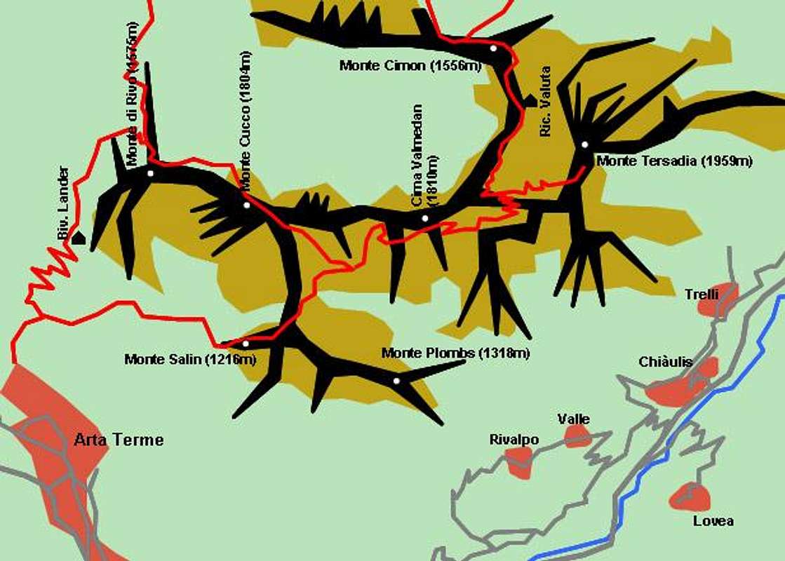
The subgruop which is located around Monte Tersadia is the smallest one of the Southern Carnic Alps. It is also rather low, even Monte Tersadia, the highest mountain is lower than 2000m. Still the subgroup is of alpinistic importance since the main ridge is composed of rocky terrain with high walls (mostly south walls). Also the main ridge forms a horseshoe-formed bend, which is a clear indication of its origin: an atoll in the Thetys Sea, which covered the area in precambrian times.
The Tersadia Group is bounded by Val Pontalba to the north, Canale di S. Pietro to the west, Canale di N Caroio to the south and west.
Main Ridge (north to south-west)
- Monte Cimon (1556m)
- Monte Tersadia (1959m)
![]()
- Cima Valmedan (1810m)
- Monte Cucco (1804m)
- Monte di Rivo (1575m)

Southern Side Ridge
- Monte Salin (1216m)
- Monte Plombs (1318m)
7 - Sernio - Grauzaria Group
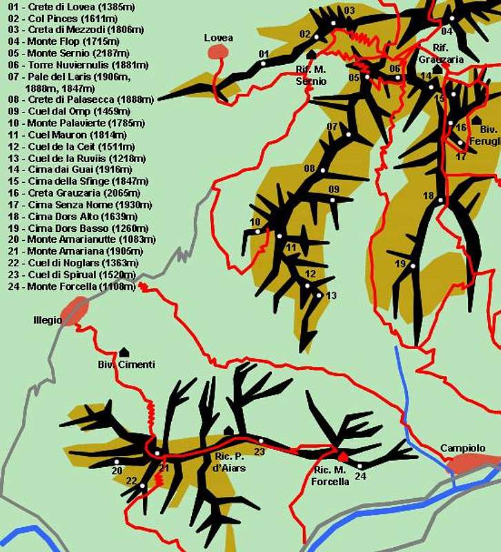
To the east of the Southern Carnic Alps you can find - once again - a number of alpinistically important mountain ranges. The first (westernmost) of these is the Sernio - Grauzarioa Subgroup. It consists of four ridges, two of which (the northern- and southernmost ones) lead from west to east, while the other two lead from north to south. These latter two ridges are the most important ones of the subgroup and their form - seen on a map - reminds you of Scandinavia (Norway and Sweden). Both Monte Sernio and Creta Grauzaria can be climbed with the help of ferrate. A rifugio serves each of these mountains respectively.
The subgroup boundaries are: Forca Griffon to the north, Canale di N Caroio to the west, Canale del Ferro to the south and Val Aupa to the east.
Northern Foothills
- Monte Flop (1715m)
Monte Sernio Ridge (north to south)
- Crete di Lovea (1385m)
- Col Pinces (1611m)
- Creta di Mezzodi (1806m)
- Monte Sernio (2187m)
![]()
- Torre Nuviernulis (1881m)
- Pale del Laris (1906m, 1888m, 1847m)
- Crete di Palasecca (1888m)
- Cuel dal Omp (1459m)
- Monte Palavierte (1785m)
- Cuel Mauron (1814m)
- Cuel de la Ceit (1511m)
- Cuel de la Ruviis (1218m)

Creta Grauzaria Ridge (north to south)
- Cima dai Guai (1916m)
- Cima della Sfinge (1847m)
![]()
- Creta Grauzaria (2065m)
![]()
- Cima Senza Nome (1930m)
- Cima Dors Alto (1639m)
- Cima Dors Basso (1260m)


Monte Amariana Ridge (west to east)
- Monte Amarianutte (1083m)
- Monte Amariana (1905m)
![]()
- Cuel di Noglars (1363m)
- Cuel di Spirual (1520m)
- Monte Forcella (1108m)

 |
8 - Zuc dal Bor
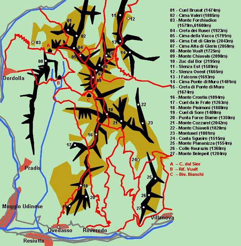
The Zuc Dal Bor Subgroup is the easternmost of the Southern Carnic Alps Groups. It consists of a central mountain, Zuc dal Bor, from which four ridges run in all directions. Zuc dal Bor itself can be reached using a ferrata (Alta Via C.A.I. Moggio).
The subgroup is bounded by Val Pontebbana to the north, Val Aupa to the west and Canale del Ferro to the south and east.
North-Western Ridge (north to south)
- Crete Dal Cronz (1664m)
- Cuel Brusat (1474m)
- Cima Valeri (1885m)
- Monte Forchiadice (1579m, 1600m)
- Creta dai Rusei (1923m)
- Cima della Vacca (1791m)
- Cima Est di Gleris (2043m)
- Cima Alta di Gleris (2058m)
![]()
- Monte Vualt (1725m)
- Monte Chiavals (2098m)
![]()
- Zuc dal Bor (2195m)
![]()
North-Eastern Ridge (north to south)- Slenza Est (1589m)
- Slenza Ovest (1665m)
- I Falcons (1693m)
- Cima Ponte di Muro (1481m)
- Creta di Ponte di Muro (1674m)
South-Western Ridge (north to south)- Monte Crostis (1894m)
- Cuel da le Frate (1263m)
- Monte Pisimoni (1880m)
![]()
- Cuel di Sore (1400m)
- Punta Force Diame (1350m)
South-Eastern Ridge (north to south)- Monte Cozzarel (2042m)
- Monte Chiaveli (1820m)
- Montusel (1881m)
- Costa Sgueire (1515m)
- Monte Plananizza (1554m)
- Colle Naurazis (1368m)
- Monte Belepeit (1284m)


Getting There
From Venezia
- Take motorway A27 north in direction of Belluno. From the end of the motorway take SS51 north to Pieve di Cadore. Here turn on SS51bis (still northward) from where you can turn east on SS52 to Forni di Sopra / Sotto, on SP619 towards Sauris or SR355 to Sappada and Forni Avoltri.
- You can also take motorway A23 north-east in the direction of Villach in Austria. At the exit Tolmezzo you can turn on SS52 east, from where you can reach all destinations in the southern Carnic Alps.
From Austria
- Take motorway A10 southward from Salzburg to Villach, where you turn south-west onto A2. At the Austrian Italian border it turns into A23 which leads to Tolmezzo. Get off there onto SS52 east and head for your final destination in the Southern Carnic Alps.
Red Tape
There is no red tape to speak of here. Most parking places are without fees in summer. In winter the parking lots around Monte Zonlolan will be charged.
When To Climb
As usual with most of the mountains of the region the climbing and hiking season is June through September. You can be lucky before and after that but this depends on the overall weather. The Arvenis and Tersadia Groups can be hiked all year round. They are also the only ones which see any ski-traffic in winter.
Weather Conditions
For up to date weather information follow one the links below.
Accommodation
Look on the following pages for accommodation in the Southern Carnic Alps:
- S. Stefano di Cadore
- Sappada
- Forni Avoltri
- Pontebba
- Arta Terme
- Tolmezzo
- Ravascletto
- Sauris
- Forni di Sopra
As for mountain huts and refuges, please see the corresponding section on the Carnic Alps Main Page.
Maps 'n' Books
Maps
Tabacco Maps, all 1:25000 - 001 - SAPPADA-S.STEFANO-FORNI AVOLTRI
- 002 - FORNI DI SOPRA-AMPEZZO-SÀURIS-ALTA TAGLIAMENTO
- 009 - ALPI CARNICHE / CARNIA CENTRALE
- 013 - PREALPI CARNICHE-VAL TAGLIAMENTO
As for books please look at the corresponding section of the Carnic Alps page (only the Italian ones).
dmiki - Mar 5, 2006 11:45 am - Hasn't voted
Monte Zincolan / Zoncolan typo?Hi, I think 'Zoncolan' is the correct spelling. Michael
Gangolf Haub - Mar 5, 2006 3:44 pm - Hasn't voted
Re: Monte Zincolan / Zoncolan typo?You're right of course - it was a typo. But I got two out of three correct! :-)
Vid Pogachnik - May 11, 2006 10:55 am - Voted 10/10
Sernio/GrauzariaHi, Gangolf! In the Sernio/Grauzaria chapter you are saying that both these summits can be reached by ferratas. That's not true. There are marked routes, but not protected with a single peace of iron. It's easy climbing II+ (Grauzaria) and II- (Sernio). You might also link in the text, where you list mountains, to the Grauzaria page. Also the ascent on Zuc dal Bor (the last group) is (I think) not a ferrata. Or may be it was. I didn't climb it, but my friend Andrej Masera says, that the route was destroyed during the last earthquake, so it is now UIAA III degree, and so considerably harder than if you say there's a ferrata. Cheers! Vid