
-
 22867 Hits
-
 84.82% Score
-
 19 Votes
|
|
Mountain/Rock |
|---|---|
|
|
40.38442°N / 111.63645°W |
|
|
Utah |
|
|
Hiking, Mountaineering, Scrambling, Skiing |
|
|
Spring, Summer, Fall, Winter |
|
|
11722 ft / 3573 m |
|
|
Overview
The second-highest summit on the Mt Timpanogos massif, only 27 feet lower than Timpanogos itself, and the third-highest peak in the Wasatch Range (with a 300' prominence rule), does not have an official name. It is labeled on USGS maps with only its elevation of 11,722 feet.Michael Kelsey, in his classic book Climbing and Exploring Utah's Mt Timpanogos, denoted the peak as "the 2nd Summit" and I gave serious consideration to titling this page with only that name. I decided to give it a hybrid name for two reasons. First, the name "2nd Summit" begs the question of "second in relation to what?", and I think the peak deserves a less generic name, even if "South Timpanogos" retains the implication of second-class status in relation to the Timpanogos summit itself, since it deserves that status as well. Second, this is SummitPost, and there is some precedent here in calling the peak "South Timpanogos."
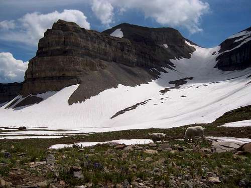 The Second Summit above and left of the "glacier" - photo by gjagiels
The Second Summit is perhaps most widely recognized by hikers as the peak on the other side of the glacier saddle from the Timpanogos summit, south-southeast from the hut. Despite its proximity to an extremely popular route, it is so heavily overlooked that it does not have much of a discernibly worn path to its summit from the saddle. It therefore makes a worthwhile "off-the-beaten-path" objective, and provides excellent views in all directions.
 View of Mt Timpanogos from the Second Summit
Getting There
Access to the popular trailheads for the easiest ways to South Timpanogos are the same as for Mount Timpanogos itself, namely, from the Alpine Loop scenic loop, U-92, (accessible from Provo Canyon or American Fork Canyon). Aspen Grove and Timpooneke are the most common trailheads for reaching the Glacier Saddle route, but Second Summit can also be climbed from Sundance via the Stewart Falls Trail into Cascade Cirque or Big Provo Hole. The Glacier Saddle can also be reached from the west and southwest, via the Battle Creek and Dry Canyon trailheads, respectively; this is best done as a spring snow route.Red Tape
Again, this is the same as for Mt Timpanogos. Two considerations bear repeating or emphasizing here. First, there is a fee booth at either entrance to the Alpine Loop; the fee has recently increased from $3 to $6 for a 3-day pass. Credit cards and checks are accepted.Also, please practice Leave No Trace wilderness ethics, above and beyond complying with the Mount Timpanogos Wilderness Area regulations, which include the prohibition of campfires and of switchback shortcutting.
When to Climb
The peak can be climbed year-round. Summer conditions find it a crumbly pile of unstable limestone (Oquirrh Formation) talus and scree, class 2 by the easiest routes. Sturdy boots are virtually essential. In winter or spring conditions, it would make an excellent ski mountaineering objective (with epic descent routes towards the south and east) or consolidated snow climb with ice axe and crampons. Be warned that all routes pass extensively through serious avalanche terrain, and winter or spring climbs should be only be undertaken during stable conditions with proper avalanche training and gear.Maps and External Links
NOAA/NWS snow, weather, and mountain conditions linksNOAA/NWS 7-day forecast for 10,000' level in the Timp area.
USGS Timpanogos Cave 7.5' Quad.
Ski descent photo trip report by trackhead.