
-
 9213 Hits
-
 82.34% Score
-
 15 Votes
|
|
Mountain/Rock |
|---|---|
|
|
43.39880°N / 103.6911°W |
|
|
Fall River County |
|
|
Hiking |
|
|
4848 ft / 1478 m |
|
|
Overview
 The old Parker Peak Fire Tower
Parker Peak has the distinction of being the highpoint of Fall River County, South Dakota. According to Lists of John, Parker Peak has 683 feet of rise, ranking it #13 in the Black Hills for prominence. The nearly flat summit area commands a sweeping view of the southern black Hills, which is why there was a fire tower there for a number of years. Peaks identifiable from the summit, include Harney Peak, Sylvan Peak, Mount Coolidge, and Battle Mountain to the north, Matias Peak to the west, and Horse Trap Mountain to the east. This area is part of the Black Hills National Forest. The Custer office (605-673-9200) is actually supervising this area, even though the Hot Springs office is closer. Many years ago, this area was more heavily forested, but fires have eliminated whole sections of that forest, ironically including the slopes of Parker Peak itself. The dead timber on the rocky slopes makes hiking up a slow and sometimes tedious process, especially on the western side.
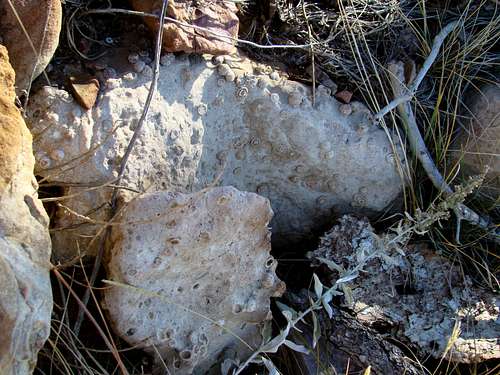 Parker Peak Fossils
In 1890, a Black Hills railroad line began construction, running from Edgemont on the southern edge of the hills, north to Deadwood. The railroad was built and initially operated by the Chicago, Burlington and Quincy Railroad. The route went right by the western base of Parker Peak. In 1983 all railroad operations ceased, and in 2007 the rail bed was converted into the 109-mile long Mickelson Trail. Geologically, Parker Peak is interesting for fossils and some unusual small rock formations. The surrounding landowners have had to contend with trespassers searching for fossil cycads, ever since the nearby Fossil Cycad National Monument was plundered. Most of the rock in the mountain is limestone, shale, or sandstone.
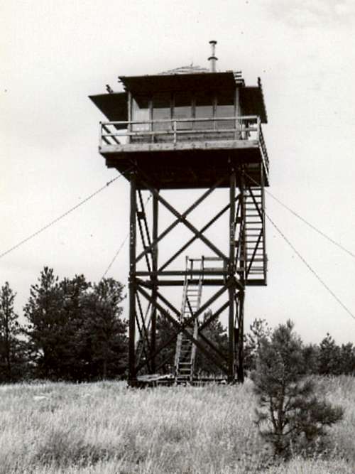
The Parker Peak Fire Tower
 Parker Peak Fire Tower Foundations
 Scott Springs Ranch south of Parker Peak
Parker Peak was probably most well-known for the old fire tower that stood at the summit from 1941 until it was removed from service sometime in the 1960’s. Like so many wooden fire towers, this 30-foot wooden tower deteriorated during its years of use, with the stairway eventually being deemed unsafe. Sagging guy wires only added to the problem of the tower swaying in windy weather. Gail and Herbert Duncan spent 20 years as the tower lookouts, before the tower was retired and dismantled. All that remains of the old fire tower are the four concrete foundation pads.
Getting There
Parker Peak is just to the east of Highway 18. From Hot Springs, travel south on highway 18 for about 14 miles and you will be on the west side of Parker Peak. From Edgemont, travel north on Highway 18 for about 10 miles to reach Parker Peak. The County Road 185 intersection will give you a good place to get off the highway and go to the location you have obtained permission to access the mountain.
Red Tape
There are no restrictions to be on the summit, since it is national forest land. But, you will need private landowner permission to cross to that public land (see below).
Routes
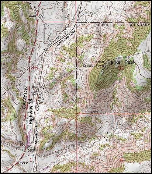 Parker Peak Map
Interestingly, the summit and upper slopes of Parker Peak are all on federal land. But, that’s where it ends. The surrounding land is all private property. Because of fires, vandalism (including the artifacts at nearby Craven Canyon and the former Fossil Cycad National Monument), and careless people who have entered private land and left stock gates open (allowing cattle to escape), the local landowners are very reluctant to allow anyone access to hike to the summit. Getting permission to cross private lands will depend on your ability to persuade them of your integrity and responsibility. And if you can successfully do that, it will determine which side you are allowed to bushwhack up. The old access road for the fire tower is on the east side, out of sight of the highway. Of course, you can’t count on using that unless that is the side whose owner you are able to obtain crossing permission. If you have checked maps of Parker Peak, you will have noticed that the Mickelson Trail runs right in front of the mountain. While the trail is for public use, unfortunately there is still private property between the trail and the mountain.
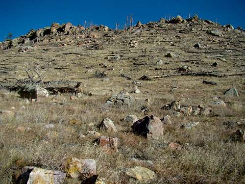 The upper western slope of Parker Peak
So, how does one find out who owns the private land? How do you contact them? Most of these people are very private and would not want their names and contact info posted on the web. So, here is a useful link to find who the current owners are: Fall River County Landowner Map It may take you a little practice to get used to the zoom in and out features, but it will reveal who the current owners are. Of course, you will need a topo map to coordinate with the landowner map. Googling for the owner’s phone number is normally sufficient to give the desired result. A few hikers have tried just going to the front door of the ranch house nearby to ask permission. I would not recommend a long trip just for this peak alone, based on the assumption they would say yes. But, if you are hiking other places in the area, like Matias Peak or Red Canyon, that approach might be worth a try.
When To Climb
Assuming you have private landowner permission, weather will be your only other consideration. For the latest area forecast, click the link below: Parker Peak – Edgemont Area Weather
Camping
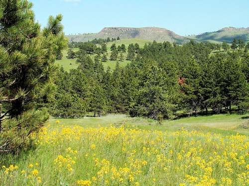 A view of Parker Peak from national forest land by Matias Peak
You can camp almost anywhere in the Black Hills National Forest, except where posted. If you are unsure, you can always check with the national forest service office in Hot Springs. Their phone number is (605) 745-4107. For other camping options in the area, check out the resources below:
Hot Springs Chamber of Commerce Camping & Lodging
Edgemont Campground
800 Second Avenue
Edgemont, SD 57735
(605) 662-7057
Maps
The Black Hills South map, published by National Geographic, is an excellent map for the area. If you are exploring any of the national forest lands in the area, their office in Hot Springs offers a free Motor Vehicle Use Map for the Black Hills National Forest.