As a preface, I must apologize that this is not one of those heroic, hanging-by-the-fingernails trip reports. Actually, it’s about a very difficult trek made “easy” by the flexibility and mutual concern of all involved.
Nearly every year,
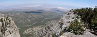
BW leads a hike over the Mummy Range in southern Nevada. This traverse takes one over 4 peaks (three above 11k) for a total of ~5000’ accumulated elevation gain, over ~8 trailless miles.
The timing of the hike is problematical; too early in the year, and one is likely to hit large snow patches; too late, and afternoon thunderstorms will send hikers scurrying from fear of electrocution. Let me emphasize right away that this “hike” is very different from the classic (relatively easy) ascent of Mummy by the scree slope on the N side of the North Loop Trail.
Mountain trips in southern Nevada are made difficult by cliff bands. It is hard to explain this idea to outsiders, who think of the geography of the Sierra or Rocky Mountains, and insist they understand cliff bands. But most of our high mountains are composed of persistent layers of siliceous limestone, with varying erosion resistance. A ridge that appears gentle and continuous from afar may actually contain a succession of 20-50’ cliffs, where tougher limestone layers suddenly appear; and the cliff bands may continue for miles. A seemingly simple descent down a valley may cross nearly impassable dryfalls over limestone strata; one may sidetrack to the next parallel valley, and find the same band blocking progress. Thus the route on a mountain typically involves finding a set of chutes and chimneys through cliff bands that would otherwise force a technical climb. To make things more exciting, the limestone often consists of totally untrustworthy fractured chunks – “portable handholds”. Few people travel these remote hikes, thus the routes are rarely cleared of dangerous loose rock.
And so goes the Mummy traverse. Predefined routes must be followed, or one must expect to spend a great deal of time in route-finding on steep talus slopes at altitude.
Our 2006 hike
The only practical way to do the hike is with a car shuttle. We first parked one car at the North Loop Trailhead near the Hilltop Campground on route 158. Then we drove to Lee Canyon, and parked several cars at a large lot on the west side of route 156 (about 0.9 miles south of the intersection with route 158). From there, we walked south about a hundred yards along the road, then cut SW up the canyon between Mummy’s Nose and Mummy’s Forehead.
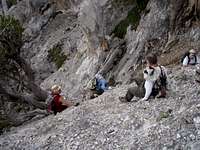
One problem we noticed right away: we had 14 people. In the limestone mountains of southern NV, rockfall is perhaps the deadliest hazard, and one has to decide how a group should be spaced to minimize that danger. All, however, had the determination for the hardest part of the hike; our sotto voce motto was, "slowly but surely". Our hike leader also provided alternative routes for those who didn’t feel like hanging from their fingernails.
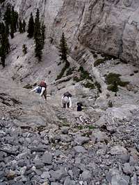
The first gully between Mummy’s Nose and Forehead is a short, steep slog, with ~2000’ elevation gain. A conventional GPS will often lose lock here, because the steep canyon walls cut out the view of most satellites. After 2000’ of ascent, the “use trail” ends abruptly near a wall on the south (R) side of the gully, just a bit below the height-of-land notch. At that point, there is a brief 3rd-4th class climb on the S wall; one actually climbs west to a ledge. There is a subtle rock horn in an alcove on the east side of the ledge, where one can anchor a rope or webbing strap. After we climbed up this pitch, we then traveled east around the corner.
Then we cut left up a steep stretch (a few class 3 moves). As we were coming up one tough class 3 pitch, I noticed that V1 was eating a cracker, while climbing. At the top of the section she offered me a saltine, which I declined. Eventually we reached the “pygmy forest” (composed of short tough bristlecone pines – name coined by NN). From this point, it was mainly a scenic slog south to the top of the Forehead at ~11k’. Along the way, V1 insisted I take her picture as she climbed a tree.
At the summit of the Forehead, we looked south and saw out next destination: the Chin, perhaps only 1000’ away as the crow flies. However, there are no easy routes to the Chin. Obviously, one downclimbs to start.
Then there are 3 possible paths: 1) drop down far to the left (N) for a simple but miserable traverse on talus, perhaps losing 200’ vertical below the col; 2) continue straight on the 3rd-4th class knife edge; or 3) pick an intermediate route between the two, on the left side of the ridge, and be prepared for 4th class travel or some belays. Each route was taken by groups of 4 to 6.
NN and LL quickly took off on (3), over the knife edge. I was intrigued by this possibility, and decided to follow. When I caught up with them, they were carefully traversing on the S side of a rock fin, with at least 200’ of exposure at their backs. When they had completed the traverse and were on relative terra firma, I decided: what the heck, I’d just walk down the top of the fin, which was about 1-2’ wide. This option turned out to be a little iffy, as the rock was crumbly, and the fin ended in an abrupt 6’ drop, with miserable exposure on the left and right (I’m sorry I took no pictures here, but didn’t have the concentration to pull out my camera). My “walk” was more of a waddle. At the end of the fin, I had to lower down 6’ to reach the ridge line; I hugged multiple protuberances at once – each untrustworthy alone – and lowered down to a small notch. At this point I looked S to NN and LL, who were downclimbing a wider, more sedate section of the ridge. “Thank God,” I thought to myself, “that no one else followed me down that fin.” At this point I heard, “Hello! Where are you?” in the distinctive Slavic accent of V1. She was coming down the ridge after me. V1 is a better climber than I, but is also shorter; so we spent a bit of time trying to figure out where to put her feet. Then we joined NN and LL at the low point between Chin and Forehead.
After waiting in the col for 10 minutes, we began to wonder what happened to the other 10 members of the party. I then heard some commotion, and looked N to the E side of the knife edge; and there was BW, lowering a doubled rope about 50’ over a steep pitch. He then downclimbed unprotected, and quasi-belayed the bottom of the rope, until rockfall convinced him otherwise. This invigorating route (2) was taken by 6 members of the party, which left 4 unaccounted. But gradually, the remaining 4 completed route (1), the miserable talus slog low on the E of the ridge.
Now we slogged up the class 2 and 3 ridgeline to the top of Chin, where we were totally swarmed by butterflies. The sky, now darkened with tall clouds, gave us some worry; there weren’t many places to bail on the next stretch. Last year, we were caught in a lightning storm S of Chin, where the rain and hail made the 45 degree rock like a waterslide. We had to drop down a steep valley, negotiating multiple dryfalls; I didn’t relish repeating that trip. So we moved quickly to the next obstacles; a series of steep slopes on the west side of the ridge.
Now at the lowest point since Forehead, we had to cut back up to Mummy’s Tummy. (Sidenote: The Tummy is what most people regard as “Mummy”, and most climb it by a relatively easy
route from the North Loop Trail.) Rimmed in by 100-200’ cliffs, there is only one option at this point: a seemingly 4th-class, 50’ cliff band. Actually, this rock is so tough and frictional, that the climbing is 3rd class at best. The greatest danger is that the first climbers to top the cliff will dislodge loose talus onto those below – and this IS a very serious danger.
After that cliff band, we came out on the NW side of Tummy, and met some friends who’d come up the traditional talus slope. We joined them for a gentle walk to the high point – peak number 3.
Now came the “descent” to the col before the Toe. This trip is technically downhill, but involves so many gratuitous 50-100’ climbs, that you will swear it is actually uphill. The descent begins with travel down a gully just N of the benchmark and register. After reaching the base of the gully, one turns a sharp right SE, and travels along the base of the cliffs. In most years, this cool NE side of Tummy has snow patches well into July. There are numerous cliff bands to wind in and around, and the route-finding is a little tricky.
Eventually, we got around the cliffs, and emerged, once again, onto the ridgeline. From there it was a scenic downhill walk, sometimes on steep talus, to the Toe. I was acting as “sweep” at this point, and somehow found myself alone at the Toe summit, where I got a self-portrait. I then hurried down and met the rest of the party as they were heading for Mummy Springs.
At this point, AB and I were chatting and lagging behind the rest of the group. We knew the other folks intended to take the Mummy Springs and North Loop trails back to the car parked on Route 158, but we had told them not to wait for us. That formal trail involves some uphill slogs and many switchbacks that seem endless on return hikes. So, AB had no trouble convincing me to take a trailless shortcut directly down to Deer Creek. That shortcut takes one down an easy ridge to running water, and abundant columbines, and frankly, is more enjoyable to me. We actually met the rest of our party at the car just as they finished the NLT.
We then spent an inordinate amount of time figuring out how we could fill the one small car with enough people to drive to our starting place on 156, pick up the other 4 cars, and drive back to pick up the folks we had left at the NLT. I guess that process was a testament to how few brain cells we were able to muster at this point.


Comments
Post a Comment