
|
|
Route |
|---|---|
|
|
43.34646°N / 1.85475°W |
|
|
Hiking, Mountaineering, Bouldering |
|
|
Spring, Summer, Fall, Winter |
|
|
Half a day |
|
|
Walk-up |
|
|
Overview
This route starts from the small fishing village of Pasaia Donibane (found in some maps as "Pasajes de San Juan". It offers an easy uphill hike for a full morning in the nature, halfway between the urban landscapes south of the mountain and the sea that covers the north side.Getting There
ROAD ACCESS: The closest province capital is Donostia (that's the basque name, in spanish maps you could find it as San Sebastián). The city is a most beautiful one, placed on National Road #1 (the one leading from Madrid to Irún) scarcely 13 km away from Pasaia Donibane. Leave Donostia eastwards and just follow the road signs towards "Francia". After 8 to 9 km driving, and take the exit 4B and follow the signs for Errenteria (first) and Lezo (afterwards). Pasaia Donibane is placed about two kilometers further along the shore.TRAIN ACCESS: As Irún is one of the main links between the spanish railroads and the rest of Europe, train communications are good enough. Your initial destination stations when coming in might be Donostia/San Sebastián or Irún. There's a narrow track railroad linking Donostia with Irún (locally known as "Topo") which leaves Donostia from the Amara Station. It's got stops in almost every village in-between. Take it until you get to the Pasaia station. The real trailhead is still about 5 km away, and therefore additional transport shall be required.
AIR ACCESS: The closest airport is placed at Hondarribia, right under Jaizkibel. It's got connections with Madrid and Barcelona. There's also the possibility to fly in to the french airport of Biarritz.
Route Description
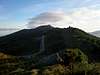
Start walking from the entrance to the old village of Pasaia Donibane. Car traffic is restricted in the village, and therefore you will have to park before. The main street leads grossly northwards, along the shore and towards the exit of the harbour to open sea. Just follow it for some 15 to 20 minutes. After that time, you will reach a spot where the path makes a wide turn to your right before going on northwards. That's where you take a deviation to your right (eastwards), beginning the real climb and leaving the sea behind.In this picture that would mean to take the obvious path leading uphill, perpendicularly away from the shore.
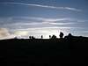
That way, you will hike along a forest area -mainly pines- to reach a flatter area (some maps call it "Collado de Lezo") close to the Pasaia-Hondarribia road. Turn left -eastwards- to follow a concrete road and join the asphalt road walking along it for about 600 meters. Shortly before the road plate of the kilometer 5, enter a path to your right into a small pine forest. It will lead you to the first tower of the ridge and all you will need to do after that is to follow the path eastwards, to reach the first set of antennas, walk around its right (southern) side and set your feet over the ruins of the ancient fort of San Enrique. That's the real summit of Jaizkibel.
 |
 |
 |
 |
 |
 |
Essential Gear
Nothing really necessary, just bear in mind proximity to the sea makes it quite a rainy area (even in summer time) and some waterproof gear shall always be welcome. Walking poles are always nice, too.External Links
RENFE: web page for the spanish national railroads."Topo": Information for the narrow track railroad between Donostia and Irún.
Camping sites: Camping sites in nearby villages. Click on their names in the leftmost column.
Camping Jaizkibel: English language info on the Jaizkibel camping site in Hondarribia.