
-
 13109 Hits
-
 80.49% Score
-
 12 Votes
|
|
Mountain/Rock |
|---|---|
|
|
43.20250°N / 4.802°W |
|
|
8018 ft / 2444 m |
|
|
Overview
 P.Castil
 Castil and Urriellu
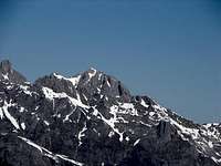
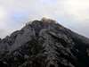
Peña Castil is one of the most interesting mountains of the Central Massif of the Picos de Europa specially for its big view of the faces north and east of the Picu Urriellu (or Naranjo de Bulnes) and of the rest of big peaks of this massif. The climb is generally easy and only it consists of overcoming the important slope (more than 1200 meters) that separates us from the top.
Darkened by its popular neighboring mountain it must not be forgotten for the mountaineers who do not feel capable of climbing the myth of the Picu Urriellu (rock technical climb) but they do not contenting with doing the very crowded walk up to Urriellu's refuge (one of the most popular walk-up of the Picos de Europa after the route of Cares).
Owed therefore to that it is less frequented this route will be necessary a bit of sense of the orientation and the consult of a map to follow it though in general the cairns are visible largely of the normal route that generally accompanies the route of Urriellu's refuge up to Tresmoñas's Majada (Sheepfold). An alternative option of ascension exists from the refuge but it is excessively long though it can be contemplated for mountaineers that have stayed in it and could not promote the Picu due to the bad weather conditions.
 |  |  |  |  |
Picos de Europa
 P.Vieja & P.Castil
The Picos de Europa constitute the most important massif of the northwest of Spain and they form a part of the Cantabrian Mountain chain, being known geologically in occasions as the Cantabrian Pyrenees. The name Picos de Europa (Europe's peaks) comes from the sailors who were spying these peaks from the sea and this way they knew that they were coming to the continent from the seas of the north.
The Picos de Europa are subdivided in 3 big massifs:
-Oriental (eastern) or Massif of Cornión
-Central or Massif of Urrieles
-Occidental (western ) or Massif of Andara.
It was the first national Park established in Spain from 1918 and politically it corresponds to the provinces of Asturias, Cantabria and León (the latter located in the community of Castilla-Leon). Pedro Pidal, Marquess of Villaviciosa, he was the man who founded the park and he was as well the first man who climb the Picu Urriellu (with the local guide Gregorio Pérez, "el cainejo"). The tomb of pedro Pidal can be visited in the park in the wonderfull Mirador (viewpoint) de Ordiales.
The origin of the name Picos de Europa: the oldest name of this mountainous chain is attributed to the Roman civilization that called it Mons Vindius. Subsequently the arabian historians would call them Montes de Pelayo (Pelayo's mountains) by being the redoubt of the resistance against the invasion headed by this man. The origin of actual name it's mysterious but it seems that was given by the navigators that originating in America they arrived for the north to the Spanish coasts and they made out in the first place these peaks to know that they were in Europe.
Some of the important peaks of the massifs:
-Oriental: Morra de Lechugales (2444m), Pico Cortés (2373m), Picos del Jierru (2422m), Pico del Sagrado Corazón (2214m).
-Central: Torre Cerredo (2648m, the highest point of the massif), Pico de los Cabrones (2553m), Torre bermeja (2606m), Torre del Friero (2445m), Torre del Llambrión (2642m), Tesorero (2570m, point of confluence of the 3 provinces in the summit), Horcados Rojos (2506m), Peña Vieja (2613m), Peña Castil (2444m) and the most popular and nice mountain of the massif, the amazing Picu Urriellu or Naranjo de Bulnes (2519m).
-Occidental: Torre Santa (2596m, another mythical mountain of rock climbing), Peña Santa de Enol (2486m), Torre del Torco (2452m).
Gastronomy:
Interest point for all the people, mountaineers or not, it's the gastronomy of this zone. You must to taste the "fabes" (beans), the Cheese of Cabrales and the "sidra" (hard cider).
 |  |  |  |
Getting There
From the village of Arenas de Cabrales you must take the road to south to Tielve and Sotres (1.045m). From Sotres you can take the forest track signaled "Urriellu" in the road (1 hour of walking). After the invernales of Texu you must follow the track to a little parking under the Col de Pandebano (1.212m).see bigger map
Red Tape
No permits required, no parking pass. This mountain is located in a National Park with rules of conservation of nature. |  |
When To Climb
(may) june to september (october) are the best monthsCamping
Mountain Hut of Vega de Urriellu or Delgado Ubeda (1923m, 96 places, tel: 985925200)Sotres: Albergue Peña Castil and some little hotels.
A few of hotels in Arenas de Cabrales
 |
Mountain Conditions
Maps
Ed.Alpina 1:50000External Links
- Mountain Hut of Urriellu
page of the mountain hut of Vega Urriellu or Delgado Ubeda (spanish)
- Route climb
and with some pictures with snow (text in spanish)
- VivirAsturias
housing, hotels, auberges,...in Picos de Europa(spanish)
- Picoseuropa.net
important page with routes, information, meteo, maps,...about the massif (spanish)