
-
 4689 Hits
-
 83.1% Score
-
 16 Votes
|
|
Mountain/Rock |
|---|---|
|
|
44.74480°N / 109.5728°W |
|
|
Hiking |
|
|
Spring, Summer, Fall, Winter |
|
|
7658 ft / 2334 m |
|
|
Overview
 Sunlight Basin
There is nothing quite like the surreal experience of standing on a summit on a cold and perfectly clear winter day, surrounded by dozens of rarely climbed, rugged, and snow-covered peaks, while listening to the howls of wolves drift up from the valleys below. While I can't guarantee that you will hear or see the wolves, I can assure you that hiking on the peaks in and around Sunlight Basin in Wyoming's North Absaroka mountains is an amazing experience. Almost all of the peaks in this area over 10,000 feet require long and difficult approaches, but there are other mountains here ranging in elevation from 7,500 to 9,500 feet that are much shorter hikes and are easily accessed by the Sunlight Basin Road. Hiking these smaller mountains provides a very satisfactory glimpse of the jaw-dropping beauty in this area for people who may not be interested in seeing or experiencing up close the large populations of grizzlies, mountain lions, and wolves that rule the North Absaroka Wilderness.
Of all of the ranked peaks in this range, probably less than a quarter have official names, and this mountain is one of those that is known only by its elevation. Peak 7658 sits in the middle of the large valley just east of a small canyon called Dewey's Gateway, through which many of the big peaks of the range are visible. With 558 feet of prominence, this peak is surrounded by several large creek drainages, and the very prominent mass of Windy Mountain dominates the view to the north (see picture below).

Getting There and Hiking Information
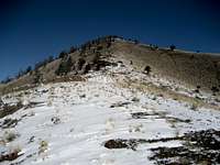 Peak 7658
 Nearing the summit
Travel north on Highway 120 for 17 miles north of Cody, Wyoming, and turn on the Chief Joseph Scenic Byway, which heads west up and over Dead Indian Pass, reaching an elevation of 8071 feet. Right at the top, there is a turnout with information signs and restrooms; the views from this overlook are nothing short of amazing. After this, the road descends seven switchbacks down into Sunlight Basin; turn left on the Sunlight Basin Road and drive for just over 8 miles and cross the bridge soon after the Ranger Station. Park off to the right just before passing through the fence over the next cattle guard.
Peak 7658 is at the top of the long and deceptively easy-looking ridge that heads north off the right side of the road. Head through the sage brush to the top of the ridge and head left; it is mostly easy walking, but there is one part of the hill that is a little steep. Once you reach the top of the steep part, the summit comes into view for the first time a little further down the ridge. The point off on the far right of the summit area is a few feet lower than the highest point, but it is worth walking over there to take a look down into the valley.
Reaching the summit of Peak 7658 is a Class 1 hike of 1.5 miles (round trip) with 800 feet of elevation gain.

Red Tape and Camping
 Bear track in Sunlight Basin
The North Absaroka Wilderness a wild place, and it contains thriving populations of grizzly bears, black bears, mountains lions, and wolves. Hike smart and carry bear spray, as the number of human encounters with these animals is rising; as I noted above, I heard the howls of wolves from the summit, and I saw two elk carcasses just off the road from recent wolf kills.
There are no fees or permits required to hike in this area; there is some private ranch property along the Sunlight Basin Road, so pay attention to posted signs. The Little Sunlight Campground is another couple of miles down the road, and is open from May 1 through November 30.
External Links
Chief Joseph Scenic BywayInformation on the North Absaroka Wilderness:
Wilderness.net
GORP site
Wikipedia
 Looking through Dewey's Gateway at Sunlight and Stinkingwater Peaks