
-
 4138 Hits
-
 74.01% Score
-
 4 Votes
|
|
Route |
|---|---|
|
|
45.16100°N / 109.772°W |
|
|
Mountaineering |
|
|
A few days |
|
|
Class 3 |
|
|
Overview
This route is describes what is perhaps the easiest way to reach the summit of Mount Peal. Most parties will take three days to climb this peak, with an intermediate camp at Phantom or Froze-To-Death lake.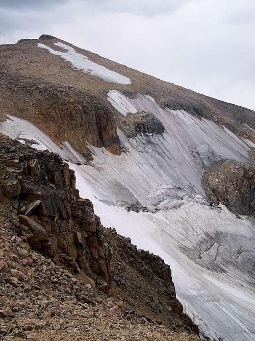 The upper Peal Glacier and summit
Getting There
This route begins at the Phatom Creek Trailhead located near Alpine, Montana. Alpine, Montana
Driving Directions from I-90 to Alpine, Montana:
1: Take exit 408 at Columbus, Montana.
2: Turn South onto MT-78 / N 9TH ST / SHEEP DIP RD. Continue to follow MT-78 / N 9TH ST. 0.8 miles
3: Turn RIGHT onto E PIKE AVE / MT-78 / US-10. 0.2 miles
4: Turn LEFT onto S PRATTEN ST / MT-78. Continue to follow MT-78. 26.8 miles
5: Turn SLIGHT RIGHT onto INGERSOL RD / E ROSEBUD RD (Portions unpaved). 0.1 miles
6: Turn RIGHT onto INGERSOL RD (Portions unpaved). 0.3 miles
7: Stay STRAIGHT to go onto E ROSEBUD RD (Portions unpaved). 1.8 miles
8: Turn LEFT to stay on E ROSEBUD RD (Portions unpaved). 1.4 miles
9: Turn RIGHT onto E ROSEBUD LAKE RD (Portions unpaved). 10.0 miles
10: Turn RIGHT onto LAKE RD. 0.1 miles
11: End at Alpine, MT US
Route Description
Follow the well maintained Phantom Creek Trail from Alpine, Montana towards the pass between Froze to Death and Saddleback mountains. As the trail begins to climb out of the valley you will encounter the first switchback. It is here that you will find a faint climbers trail which continues up the Phantom Creek Drainage towards Mount Peal. The "trail" leads up over some boulders and considerable loose scree before arriving at Phantom Lake. Several good campsites can be found near the lake. There are no trails beyond this point.From Phantom lake continue up the valley towards Froze-To-Death lake, staying on the North side of Phantom Creek. There are some faint goat trails in places which can be followed to make the climb to the next lake a bit easier (class 2). Circle around the North side of Froze-To-Death lake to avoid steep cliffs and loose scree on the South side of the lake.
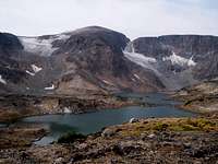 Looking at Peal from Turquoise Lake, Brent lake is at the base of the moraine below the snowfield in this picture.
Cross over Phantom Creek between Froze-To-Death and Turquoise lakes (easy rock hopping) towards Brent lake. From Brent lake you will climb up the moraine towards the lake at the base of the permanent snowfield on the East side of Mount Peal. The traverse around this lake is time-consuming, and involves some 3rd class scrambling over large boulders. Once on the glacier / snowfield strap on the crampons and make your way towards the saddle between Peal and Pleasant on the summit plateau. The angle of the glacier increases towards 45 degrees towards the top, and there are a couple of tension cracks near the top which may be hidden early in the season.
For those without crampons the easiest way to get to the summit plateau will be to follow the scree covered left (South) side of the glacier. Near the top the angle increases significantly, and the rock overlying the snowfield is dangerously loose and prone to sliding.
The difficult part of the climb is over once the plateau is reached. Once on the plateau stroll North West towards Peal's summit.
Essential Gear
The safest way to reach the summit plateau is to stay on the Peal Glacier. A Ice Axe and Crampons are needed. A Helmet would be wise if you plan to attempt the climb of the scree covered South side of the Glacier.Additional Photos
 |  |  |  |