Pre Climb
After climbing the 9000 ft Mount Mahogany a few weeks ago, I got the hiking itch. But not just hiking, I've hiked to plenty of lakes, waterfalls, etc in nearby American Fork Canyon, I wanted to summit an 11,000 foot peak. I did my research on nearby peaks, and planned on climbing Mount Timpanogos with my friend DJ. We planned on summiting on Friday, but my mom wanted to hike with me on my first trip up timp, so we planned for a later day. In the meantime, I was still wanting to summit a mountain. I decided to do Pfeifferhorn via Red Pine Lake, a climb that didn't seem to intimidating, and easy enough for my younger brother, but looked like there was enough scrambling to make it fun and adventurous. I set the date for Saturday August 8, called up my friend Spencer, and hoped the weather for Saturday would still be sunny when we went.
The night before we left, I rechecked the weather, the rainstorm that was supposedly supposed to happen on Friday had gotten pushed back to Saturday. The chances of reaching summit during a Thunderstorm was very slim, and something I wouldn't want to attempt anyway. No one wants to be the highest point with lightning around you. I never called my friend Friday night, more as a method of making sure my Dad woke up and at least gave the weather of chance. If I have a friend showing up at 6 in the morning we had to do something.
The Morning of
I woke up at 5:30, and ran upstairs to check the weather. The storm had been postponed again! I woke up my dad and brother and told them it was a go, then hurried and finished packing lunch and getting prepped before Spencer came over. We weren't able to get off until about 6:30, and the hour long drive to white pine trailhead about 5.5 miles up little cottonwood canyon meant we weren't able to get hiking until 7:30.
The Hike
The hike to red pine lake was fast and easy, we were making pretty good pace, doing 3 miles in an 1 and 15 minutes with multiple stops to take pictures of the beautiful wildflowers growing in the area. There were pretty views up and down little cottonwood canyon as well that deserved a minutes break to look at. I had heard there were a few tricky spots to stay on the trail to Red Pine Lake, and not end up at White Pine Lake, but just stay on the trail and follow the signs at the junction, and you'll be good.
![Red Pine Lake Pano]()
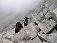
We knew we had to get up to the upper lake, but the map I had didn't show a trail to it, which there is. We didn't know that so we climbed alongside a small ridge running southeast along the boulder field that headed towards it. We ended up in the right spot, although on the way back down we found a trail that is much easier to climb on the east side of the lower lake all the way to the second lake. From the upper Lake, there was another small ridge that headed up towards the main ridge. We followed this until we reached the saddle. It was pretty steep, but nothing difficult. Once on the ridge, we stopped a while to enjoy the view of Box Elder Peak and the Utah Valley below. After a few minutes, we headed west along the ridge towards the summit, it was uneventful until we reached the the knife edge.
![Pheifferhorn s Knife Ridge]()
Upon reaching the knife edge with Pheifferhorn looming in the clouds ahead, one feels pretty intimidated. The ridge looks frightfully skinny and jagged, and then past that, Pheifferhorn juts straight up, or so it seems. It was about this moment that the different personalities in our group became apparent. My first reaction was, "SWEET! LET'S DO IT!" as I am a bit more daring than the others, on the other hand, my dad who is very cautious said it didn't look safe and wanted to turn around. Brian, my little brother, was just freaked out by the massive cloud looming at the very edge of the Ridge making it appear as if we were on the edge of the world, while Spencer couldn't decide if he was scared or excited. This clash of personalities was the cause for a long break, with a debate over what we should do. Finally, another hiker came down and told us it was very doable. This was enough to convince my dad to at least give it a shot. We traversed our way around the ridge very safely, and found a route that had minimal or no exposure, and climbed to the top, which seemed a lot more steep than it really was. Once reaching the top we were completely surrounded by a cloud, making it seem that our little peak was an island in the sky. We weren't able to stay up long, as we were not sure what the incoming weather was like. But at least we did it.
Coming down took quite some time. My brother had gotten altitude sickness, and it was a slowgoing uneventful trip down. Our total time was 7 hours 40 minutes for a 9 mile, 4,000 ft hike. I felt as if I could have done it much faster, but it doesn't hurt to go slow every once in a while.


Comments
Post a Comment