Anybody climbed St. John Mtn. next to Snow Mtn.
12 posts
Page 1 of 1
-

Noondueler - Posts: 220
- Joined: Tue Aug 21, 2007 6:55 am
- Thanked: 71 times in 28 posts
Anybody climbed St. John Mtn. next to Snow Mtn.
Anybody know about or have climbed St. John Mtn. 6,746' in the California North Coast Range just northeast of Snow Mtn.? I see a squiggly road going to the top of this beast but...?
-

Bob Burd - Forum Moderator
- Posts: 4271
- Joined: Sun Jul 22, 2001 10:42 pm
- Thanked: 572 times in 296 posts
Re: Anybody climbed St. John Mtn. next to Snow Mtn.
There's a communications tower at the summit, so it gets truck traffic. It could be closed to public traffic at the Bear Wallow TH on the south side. Less than a two mile hike from there. The road to get there is FS Road 18N06. It may be closed for the winter, I'd call the Mendocino USFS for info. The peak looks interesting though - more than 1,800ft of prominence. I'd be interested to know how the roads are if you go...
-
Noondueler - Posts: 220
- Joined: Tue Aug 21, 2007 6:55 am
- Thanked: 71 times in 28 posts
Re: Anybody climbed St. John Mtn. next to Snow Mtn.
Bob Burd wrote:There's a communications tower at the summit, so it gets truck traffic. It could be closed to public traffic at the Bear Wallow TH on the south side. Less than a two mile hike from there. The road to get there is FS Road 18N06. It may be closed for the winter, I'd call the Mendocino USFS for info. The peak looks interesting though - more than 1,800ft of prominence. I'd be interested to know how the roads are if you go...
Thanks for the info Bob. I have a van but no 4WD. It's a huge mountain, quite prominent from I-5. If i find out more about it that goes maybe this spring.
-

ScottyP - Posts: 633
- Joined: Mon Nov 10, 2008 10:43 pm
- Thanked: 36 times in 28 posts
Re: Anybody climbed St. John Mtn. next to Snow Mtn.
I've been looking at that as well if you'd like company..
-
Noondueler - Posts: 220
- Joined: Tue Aug 21, 2007 6:55 am
- Thanked: 71 times in 28 posts
Re: Anybody climbed St. John Mtn. next to Snow Mtn.
Thanks Scotty. I'll let you know if and when. Next few months a good possibility. Company would be a good incentive.ScottyP wrote:I've been looking at that as well if you'd like company..
-
ScottyP - Posts: 633
- Joined: Mon Nov 10, 2008 10:43 pm
- Thanked: 36 times in 28 posts
Re: Anybody climbed St. John Mtn. next to Snow Mtn.
I flew around it this past week. Looks fun!
-
Noondueler - Posts: 220
- Joined: Tue Aug 21, 2007 6:55 am
- Thanked: 71 times in 28 posts
Re: Anybody climbed St. John Mtn. next to Snow Mtn.
What do you think the starting point would be. Take any pics? I'm in Lake county for another couple weeks. Would consider doing the hike if you're interested.ScottyP wrote:I flew around it this past week. Looks fun!
-

jibmaster - Posts: 417
- Joined: Sat Apr 24, 2004 10:23 am
- Thanked: 39 times in 27 posts
Re: Anybody climbed St. John Mtn. next to Snow Mtn.
Was just up at Letts Lake. Great place to camp!
The gate at the bottom of St. John is still closed. I think they open it May 1st.
You don't want to hike all the way up the road. Drive around to the north side.
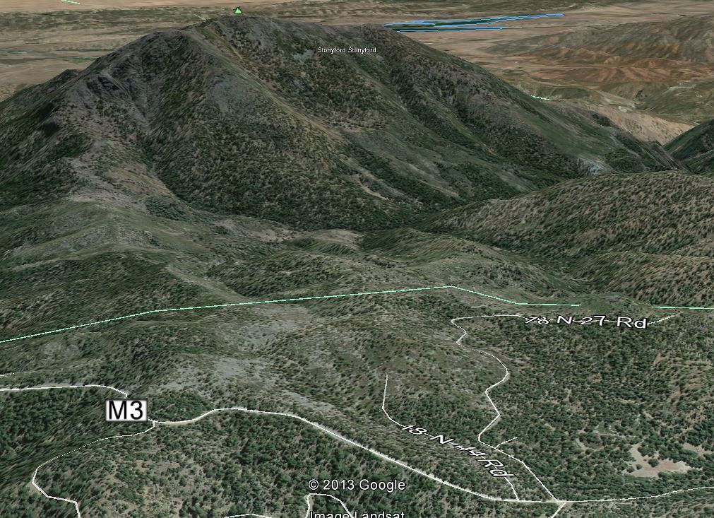
Just before the Summit Springs TH for Snow Mt., take a left and drive along the M3 (24N02) past Crockett Peak. Just after roads 18N27 and then 18N44 you will find a ridge that leads to St. John.
Play around with Google Earth to see this image:
The gate at the bottom of St. John is still closed. I think they open it May 1st.
You don't want to hike all the way up the road. Drive around to the north side.
Just before the Summit Springs TH for Snow Mt., take a left and drive along the M3 (24N02) past Crockett Peak. Just after roads 18N27 and then 18N44 you will find a ridge that leads to St. John.
Play around with Google Earth to see this image:
Coastal Crest Snow Patrol
http://www.flickr.com/photos/jibmaster/
http://www.youtube.com/user/MrJibmstr
http://www.flickr.com/photos/jibmaster/
http://www.youtube.com/user/MrJibmstr
-
jibmaster - Posts: 417
- Joined: Sat Apr 24, 2004 10:23 am
- Thanked: 39 times in 27 posts
Re: Anybody climbed St. John Mtn. next to Snow Mtn.
The road is gated at the bottom. Down by Fouts Spring.
No access to Bear Wallow TH right now.
No need for a 4X4 either. The roads are all epically smooth.
Haven't been around on the M3 for a few years now, but it's a gorgeous area.
45 minutes from Stonyford gets you to Letts Lake. Another 30 minutes to the Summit Springs TH for Snow Mountain - and the turn off for the M3.
I would bring an axe and a saw. A tree had fallen over the road just before the Summit Springs TH.
Above the M3 intersection.
Tried winching it out of the way, but it was still attached. A small saw would have gotten me through.
Coastal Crest Snow Patrol
http://www.flickr.com/photos/jibmaster/
http://www.youtube.com/user/MrJibmstr
http://www.flickr.com/photos/jibmaster/
http://www.youtube.com/user/MrJibmstr
-
Noondueler - Posts: 220
- Joined: Tue Aug 21, 2007 6:55 am
- Thanked: 71 times in 28 posts
Re: Anybody climbed St. John Mtn. next to Snow Mtn.
Thanks a bunch jibmaster!jibmaster wrote:The road is gated at the bottom. Down by Fouts Spring.
No access to Bear Wallow TH right now.
No need for a 4X4 either. The roads are all epically smooth.
Haven't been around on the M3 for a few years now, but it's a gorgeous area.
45 minutes from Stonyford gets you to Letts Lake. Another 30 minutes to the Summit Springs TH for Snow Mountain - and the turn off for the M3.
I would bring an axe and a saw. A tree had fallen over the road just before the Summit Springs TH.
Above the M3 intersection.
Tried winching it out of the way, but it was still attached. A small saw would have gotten me through.
-
jibmaster - Posts: 417
- Joined: Sat Apr 24, 2004 10:23 am
- Thanked: 39 times in 27 posts
Re: Anybody climbed St. John Mtn. next to Snow Mtn.
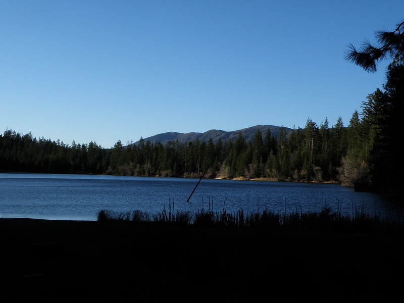
Letts Lake
May 2005

March 2014
http://www.thebackcountry.net/bb/viewto ... ?f=2&t=342
http://www.flickr.com/search/?q=Letts%2 ... 744399@N08
May 2005
March 2014
http://www.thebackcountry.net/bb/viewto ... ?f=2&t=342
http://www.flickr.com/search/?q=Letts%2 ... 744399@N08
Coastal Crest Snow Patrol
http://www.flickr.com/photos/jibmaster/
http://www.youtube.com/user/MrJibmstr
http://www.flickr.com/photos/jibmaster/
http://www.youtube.com/user/MrJibmstr
-
jibmaster - Posts: 417
- Joined: Sat Apr 24, 2004 10:23 am
- Thanked: 39 times in 27 posts
Re: Anybody climbed St. John Mtn. next to Snow Mtn.
The north side of Snow Mt. and St. John from Hull Mt.
Feb. 2010
https://www.youtube.com/watch?v=X7bwmeME0ps
Feb. 2010
https://www.youtube.com/watch?v=X7bwmeME0ps
Coastal Crest Snow Patrol
http://www.flickr.com/photos/jibmaster/
http://www.youtube.com/user/MrJibmstr
http://www.flickr.com/photos/jibmaster/
http://www.youtube.com/user/MrJibmstr
12 posts
Page 1 of 1
-
- Related topics
- Replies
- Views
- Last post
-
- Snow Creek to Mt San Jacinto climbed on 3/26/17
by Cy Kaicener » Mon Mar 27, 2017 10:06 pm - 5 Replies
- 3319 Views
- Last post by Cy Kaicener

Mon Apr 10, 2017 8:52 pm
- Snow Creek to Mt San Jacinto climbed on 3/26/17
-
- San Jacinto via Snow Creek - Snow Conditions?
by SierraSummits » Thu Apr 05, 2012 6:38 pm - 7 Replies
- 5899 Views
- Last post by jesu, joy of man's desiring
Mon Apr 16, 2012 4:40 am
- San Jacinto via Snow Creek - Snow Conditions?
-
- white mtn. webcam!
by youngclimer123 » Tue Apr 10, 2012 11:56 pm - 0 Replies
- 8599 Views
- Last post by youngclimer123
Tue Apr 10, 2012 11:56 pm
- white mtn. webcam!
-
- laurel mtn conditions?
by WML » Fri Jul 09, 2010 5:26 am - 8 Replies
- 2713 Views
- Last post by The Chief
Sat Jul 10, 2010 6:03 am
- laurel mtn conditions?
-
- split mtn accident
by jareds » Fri Apr 29, 2011 3:43 am - 8 Replies
- 3129 Views
- Last post by MoapaPk
Tue May 03, 2011 11:09 pm
- split mtn accident
Who is online
Users browsing this forum: No registered users and 0 guests