Also, while I have your attention
Huayhuash Question: San Antonio Pass vs Trapecio Pass?
4 posts
Page 1 of 1
-

marving - Posts: 36
- Joined: Tue Apr 15, 2014 3:34 pm
- Thanked: 1 time in 1 post
Huayhuash Question: San Antonio Pass vs Trapecio Pass?
Hey, just wondering if anyone has ever been over both of these passes? I know Trapecio makes things quicker and is fairly straightforward, but are the views better than San Antonio? We could take Trapecio and then the next day just hike up to San Antonio to check out the view and come back down, but if the view is clearly better from San Antonio we might just not both with Trapecio at all, especially since logistically it would be easier to coordinate if we end up using arriero's. Just curious to hear from those that have been.
Also, while I have your attention When did you go and how many days did you have clear skies vs rain/cloud/fog?
Also, while I have your attention
-

Scott - Forum Moderator
- Posts: 8549
- Joined: Thu Aug 21, 2003 1:03 pm
- Thanked: 1212 times in 650 posts
Re: Huayhuash Question: San Antonio Pass vs Trapecio Pass?
Your question is somewhat confusing since if you take the Trapacio Pass you will still either do the San Antonio Pass or the Jurau (a.k.a. Santa Rosa) Pass, which is just to the east of the San Antonio Pass (I'd suggest the eastern pass).
I believe what you might be trying to ask is the Trapacio Pass vs. the Cuyoc Pass. Both have nice scenery. The Trapacio Pass is shorter, but it also skips the hot springs. Personally, I would choose the Cuyoc Pass because of the hot springs.
Maybe 1/3 cloudy and 2/3 not cloudy in late June/early July.
I believe what you might be trying to ask is the Trapacio Pass vs. the Cuyoc Pass. Both have nice scenery. The Trapacio Pass is shorter, but it also skips the hot springs. Personally, I would choose the Cuyoc Pass because of the hot springs.
When did you go and how many days did you have clear skies vs rain/cloud/fog?
Maybe 1/3 cloudy and 2/3 not cloudy in late June/early July.
-
marving - Posts: 36
- Joined: Tue Apr 15, 2014 3:34 pm
- Thanked: 1 time in 1 post
Re: Huayhuash Question: San Antonio Pass vs Trapecio Pass?
Scott wrote:Your question is somewhat confusing since if you take the Trapacio Pass you will still either do the San Antonio Pass or the Jurau (a.k.a. Santa Rosa) Pass, which is just to the east of the San Antonio Pass (I'd suggest the eastern pass).
I believe what you might be trying to ask is the Trapacio Pass vs. the Cuyoc Pass. Both have nice scenery. The Trapacio Pass is shorter, but it also skips the hot springs. Personally, I would choose the Cuyoc Pass because of the hot springs.When did you go and how many days did you have clear skies vs rain/cloud/fog?
Maybe 1/3 cloudy and 2/3 not cloudy in late June/early July.
Map:

What I'm calling Trapecio pass is the route via Trapecio Pass and then across the glacier and over what I assume it is you mean by Jurau Pass down to Laguna Jurau. Except Jurau Pass isn't labeled on my map. So yes what I'm wondering is what offers the better views, Jurau pass down to Laguna Jurau, or San Antonio Pass down to Laguna Jurau? I briefly glanced a photo of San Antonio Pass last year and all I remember is it was impressive with views of both lakes and the peaks. Would the view from Jurau Pass be as good or better or is it not as good because the views of everything are not head on in front of you?
Also, did you hike the col between Sarapococha Lake and Caramarca Lake? Or hike/climb up Gran Vista? (see red circles on map). Just wondering what that terrain is like for both of those, if there's any scrambling involved or if it's just hiking/scree/etc..
Thanks!
-
Scott - Forum Moderator
- Posts: 8549
- Joined: Thu Aug 21, 2003 1:03 pm
- Thanked: 1212 times in 650 posts
Re: Huayhuash Question: San Antonio Pass vs Trapecio Pass?
OK, I see what you mean. I marked Jurau Pass/Santa Rosa on the map. Both passes are on either side of the peak marked 5079 (which is a very nice viewpoint).
Most people that do the Trapacio Pass drop down to the lake and then cross the Jurau or San Antonio Passes. Your proposed route is different. The route you are proposing near Huayhuashjanja is generally considered a mountaineering, rather than trekking route, but I am unfamiliar with it. It would be a spectacular route, but it might be difficult (?) so you might not want to do it alone. It looks spectacular, but rugged. The bad weather also tends to hang around right there even if the surrounding region is clear.
We went up to Sarapococha and up the hills towards Grand Vista, but since the peaks were socked in with clouds, so we didn't go to the very top.
Here is a photo from the hills above Sarapococha, before things got really cloudy:
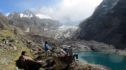
Unfortuantely, we never did see much Yerupaja or Suila Grande from that location due to cloud cover, but it was still nice. The peaks we did see were still spectacular.
The route to Grand Vista a just a trek, but it's a steep one. Mules can't do it and most people wouldn't want to take a big pack over it either. It might be best to do it as a day trip from Cutatambo rather than as an alternate route. It will be worth visiting for sure. Hopefully you have a clear view!
- map.jpg (4.17 MiB) Viewed 6130 times
Most people that do the Trapacio Pass drop down to the lake and then cross the Jurau or San Antonio Passes. Your proposed route is different. The route you are proposing near Huayhuashjanja is generally considered a mountaineering, rather than trekking route, but I am unfamiliar with it. It would be a spectacular route, but it might be difficult (?) so you might not want to do it alone. It looks spectacular, but rugged. The bad weather also tends to hang around right there even if the surrounding region is clear.
Also, did you hike the col between Sarapococha Lake and Caramarca Lake? Or hike/climb up Gran Vista? (see red circles on map). Just wondering what that terrain is like for both of those, if there's any scrambling involved or if it's just hiking/scree/etc..
We went up to Sarapococha and up the hills towards Grand Vista, but since the peaks were socked in with clouds, so we didn't go to the very top.
Here is a photo from the hills above Sarapococha, before things got really cloudy:
Unfortuantely, we never did see much Yerupaja or Suila Grande from that location due to cloud cover, but it was still nice. The peaks we did see were still spectacular.
The route to Grand Vista a just a trek, but it's a steep one. Mules can't do it and most people wouldn't want to take a big pack over it either. It might be best to do it as a day trip from Cutatambo rather than as an alternate route. It will be worth visiting for sure. Hopefully you have a clear view!
4 posts
Page 1 of 1
-
- Related topics
- Replies
- Views
- Last post
-
- Oggioni Pass route, Torres del Paine
by AlexeyD » Mon Oct 06, 2014 10:01 pm - 0 Replies
- 3945 Views
- Last post by AlexeyD

Mon Oct 06, 2014 10:01 pm
- Oggioni Pass route, Torres del Paine
-
- Cordillera Huayhuash
by Andinistaloco » Tue Apr 17, 2007 2:25 am - 8 Replies
- 4336 Views
- Last post by Brad Marshall
Fri Apr 20, 2007 11:32 pm
- Cordillera Huayhuash
-
- Cordillera Huayhuash
by jbetoo » Tue Apr 20, 2010 5:51 am - 3 Replies
- 5162 Views
- Last post by Luciano136
Thu Apr 22, 2010 5:05 pm
- Cordillera Huayhuash
-
- Climbing volcanoes San Pedro / San Pablo (near Calama,Chile)
by Andino » Wed Aug 30, 2006 10:08 pm - 1 Replies
- 1546 Views
- Last post by Ski Mountaineer
Wed Aug 30, 2006 10:25 pm
- Climbing volcanoes San Pedro / San Pablo (near Calama,Chile)
-
- Climbing in the Cordillera Huayhuash
by bledl » Fri Jun 17, 2011 8:13 am - 4 Replies
- 2712 Views
- Last post by bledl
Mon Jun 20, 2011 8:52 am
- Climbing in the Cordillera Huayhuash
Who is online
Users browsing this forum: No registered users and 0 guests