Longest lines of sight photographed.......
-

surgent - Posts: 545
- Joined: Wed Aug 20, 2003 2:45 pm
- Thanked: 143 times in 80 posts
Very rough calculations using right triangles and pythagorean formula:
Assuming radius of 4,000 miles for the earth, and assuming a perfect sphere, a 6 foot tall person can see just over 3 miles to the horizon assuming perfectly flat conditions (calm ocean). At 12 feet of height, the sighting increases to 4.25 miles. The old lookout parapets on old ships, maybe 30 feet above the deck, could increase line-of-sight distance by an extra 5 miles than if just standing on the deck itself.
Standing atop Rainier and looking out over perfectly flat terrain surrounding it would allow for about 145 miles line-of-sight to the horizon. If a peak of similar height lying beyond the horizon pokes above the horizon, then I presume one could nearly double this distance.
Thus, 200 miles is very reasonable, 250 miles is a probable practical extreme and 300+ miles is a theoretical extreme likely not to be met in practice.
-

SpiderSavage - Posts: 393
- Joined: Mon Mar 10, 2008 7:37 pm
- Thanked: 9 times in 5 posts
The farthest thing you can see to the unaided eye is the Andromeda Galaxy approximately 2 million light years away. (http://antwrp.gsfc.nasa.gov/apod/ap080124.html) This can be spotted from deserts and high altitudes near Casseopea.
I recently spotted Ranier, Adams, Hood from an airplane at about 25,000 feet while flying from Spokane to Boise.
I recently spotted Ranier, Adams, Hood from an airplane at about 25,000 feet while flying from Spokane to Boise.
-

brendon - Posts: 583
- Joined: Wed Jul 28, 2004 4:13 pm
- Thanked: 1 time in 1 post
Ok, this should be a new mountain hobby. State and county hp's, prominence peaks...
...and now, line of sight bagging.
http://heywhatsthat.com is very cool, too.
...and now, line of sight bagging.
http://heywhatsthat.com is very cool, too.
-

Dmitry Pruss - Posts: 829
- Joined: Mon Apr 18, 2005 1:17 am
- Thanked: 2 times in 2 posts
Nice pictures there! Uncomphagre CO from Ellen UT has a historical line-if-sight claim to fame, the world's longest-range heliothrope Morse code transmission (basically a fancy signaling mirror kind of technology). "Only" 182 miles though, and barely visible by eye in most seasons.
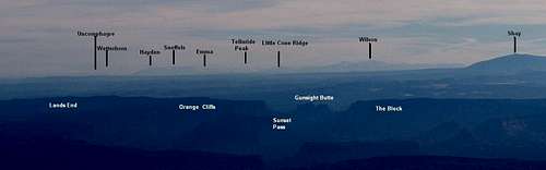
(For this and some other longp-range photos, I wrote a simple script to annotate distant peaks, converting elevations and coordinates into pixels)
(For this and some other longp-range photos, I wrote a simple script to annotate distant peaks, converting elevations and coordinates into pixels)
-

calebEOC - Posts: 518
- Joined: Tue Jun 21, 2005 3:47 pm
- Thanked: 0 time in 0 post
I have a grainy picture of jefferson from Indian Rock at 160 miles, I'll try to get a shot of adams and rainier this summer. I think from Newberry you could probably see from shasta to rainier if conditions were ideal. Its been my experience that the best time to see the cascades from the east is around 10 - 12 am before the haze has built up and the angle of the sun accentuates the glare off the snow.
-

Iron Hiker - Posts: 42
- Joined: Thu Mar 22, 2001 1:00 pm
- Thanked: 3 times in 2 posts
Here is another very good site with photos from many mountains by Petter Bjorstad, a Norwegian climber:
http://www.ii.uib.no/~petter/mountains
You can compare the Viewfinder panos from Charleston Peak, Mount Lafayette (NH), Arc Dome, Mount Jefferson (NV), and many summits in Europe with the photo panos on this site (posted under the respective summits). I thought I could just barely make out the 3 big LA area peaks on the Charleston photo pano.
Check out this pano from Mount Temple in the Canadian Rockies and compare it to Viewfinder too (many other outstanding mts and pics on this particular site):
http://eric-coulthard.com/TripPhotos.cg ... pause=true
So there are already a few people out there who have taken some pretty good shots. Let's keep hunting for more.
-

Scott - Forum Moderator
- Posts: 8549
- Joined: Thu Aug 21, 2003 1:03 pm
- Thanked: 1212 times in 650 posts
The Winds to the Uintahs could get up to some high numbers.
I would still guess that the Cascade Volcanoes probably take the cake in the lower 48.
Denali, Hunter and Foraker can all be seen from Mount Sanford. Foraker is 240 miles away. I wonder if Denali can also be seen from even more distant peaks in the Wrangells.
-
brendon - Posts: 583
- Joined: Wed Jul 28, 2004 4:13 pm
- Thanked: 1 time in 1 post
Scott wrote:The Winds to the Uintahs could get up to some high numbers.
Or even more so, the Uintas to Tetons. You can see one from the other on very clear days.
I would still guess that the Cascade Volcanoes probably take the cake in the lower 48.
Denali, Hunter and Foraker can all be seen from Mount Sanford. Foraker is 240 miles away. I wonder if Denali can also be seen from even more distant peaks in the Wrangells.
Maybe, but the entire bulk of the Wyo. Range is in the way.
This map- http://www.heywhatsthat.com/?view=BS5JALP9 -doesn't show much in that direction, a couple of spots in the desert near Big Piney. The furthest line of site that I could find for the Grand is Hyndman Peak at 166 miles.
Another interesting note, the furthest point on the valley floor where there might be a possibility of seeing the Tetons is 134 miles away. Pillar Butte in the Great Rift. I think that's within my hometown school district (and ward) boundaries.
Also, the Diamond Peak -> Teton Range view might be one of the easiest 120 mile views to find, can't miss the Tetons.
Last edited by brendon on Tue Mar 31, 2009 3:37 am, edited 1 time in total.
-
Iron Hiker - Posts: 42
- Joined: Thu Mar 22, 2001 1:00 pm
- Thanked: 3 times in 2 posts
Cache Peak, ID, is the furthest you can see from the Grand - 180 miles away. The Grand "suffers" from being close to many other big peaks so its viewshed is not really that large except over the Idaho plains to the SW.
-
brendon - Posts: 583
- Joined: Wed Jul 28, 2004 4:13 pm
- Thanked: 1 time in 1 post
Iron Hiker wrote:Cache Peak, ID, is the furthest you can see from the Grand - 180 miles away. The Grand "suffers" from being close to many other big peaks so its viewshed is not really that large except over the Idaho plains to the SW.
Holy cow, there's a red dot there.
Edit: The Middle has one there, too http://www.heywhatsthat.com/?view=EHGVCVJF , as well as 12,400 ft on the way to the Upper Saddle http://www.heywhatsthat.com/?view=SKF0H6JA
That's at least 1400 feet of visible relief from Cache.
Last edited by brendon on Tue Mar 31, 2009 4:13 am, edited 2 times in total.
-
Scott - Forum Moderator
- Posts: 8549
- Joined: Thu Aug 21, 2003 1:03 pm
- Thanked: 1212 times in 650 posts
Maybe, but the entire bulk of the Wyo. Range is in the way.
The Uintas and Tetons are higher than the Wyoming Range, so you can definately see the Tetons above them. The easiest time to pick out the Tetons from the Uintas is after the snow has melted off the Wyoming Range since it stays on the Tetons longer (otherwise you can't distinguish them). Three peaks in the Uintas that you can for sure see the Tetons from are Lamotte Peak, Beulah and Tokewanna. You can even pick them out from some of the lower ridges such as the one above the Cataract Basin. It has to be a really clear day though as it is just over 200 miles away.
-
brendon - Posts: 583
- Joined: Wed Jul 28, 2004 4:13 pm
- Thanked: 1 time in 1 post
GT at absolute 13775: http://www.heywhatsthat.com/?view=NGF0G1KC
GT at absolute 14000: http://www.heywhatsthat.com/?view=QMP7BF5M
14500 http://www.heywhatsthat.com/?view=CCF9APUH
16000 http://www.heywhatsthat.com/?view=OV92I45V
Still nothing. Curvature of the earth is winning.
Here's the profile at 16k, running to the east of the Wyo's to the eastern Uintahs:

GT at absolute 14000: http://www.heywhatsthat.com/?view=QMP7BF5M
14500 http://www.heywhatsthat.com/?view=CCF9APUH
16000 http://www.heywhatsthat.com/?view=OV92I45V
Still nothing. Curvature of the earth is winning.
Here's the profile at 16k, running to the east of the Wyo's to the eastern Uintahs:
-

Dartmouth Hiker - Posts: 56
- Joined: Fri Nov 25, 2005 12:37 am
- Thanked: 5 times in 4 posts
Ok, assuming we're at the equator (where the curvature of the earth is minimized) and there are two Everest-sized mountains directly on the equator, with nothing in between and with one 2-meter tall person atop each, the maximum theoretical distance between the summits that could be seen (ignoring stuff like refraction) would be 672.2242 km (417.7 miles). Obviously, reality will not even be close to this.
FWIW, the longest view in the Northeast seems to be Washington to Marcy (or vice versa--I was able to see Washington on an exceptionally clear winter's day from atop the latter).
The longest view I've seen, period, was Humphreys Peak from approximately 250 miles away on a flight out of Phoenix...
(as a sidenote, I've known about heywhatsthat.com, but completely missed the fact that they had profiles and visibility cloaks. Wheeeee! )
-
- Related topics
- Replies
- Views
- Last post
-
- Speaking of those Chilean miners, what's the longest......
1, 2by Tanngrisnir3 » Wed Oct 13, 2010 6:32 pm - 25 Replies
- 6627 Views
- Last post by Teresa Gergen

Thu Oct 21, 2010 5:53 pm
- Speaking of those Chilean miners, what's the longest......
Who is online
Users browsing this forum: No registered users and 0 guests