Hey there, I was contemplating a trip Sun-Mon to climb either the Winter Route or Winter Chimney on LPP's south face. I've read very little about either other than what is on SP and in the Secor book....
So what I'm sayin' (or askin') is two things:
1. What are current road conditions for Tuttle Creek TH?
2. Does anybody have any info RE: either of the aforementioned routes on Lone Pine Peak?
Thanks so much!
Weston
Tuttle Creek TH Conditions + S Face Routes of LPP beta
8 posts
Page 1 of 1
-

kevin trieu - Posts: 979
- Joined: Mon Mar 21, 2005 5:59 pm
- Thanked: 88 times in 64 posts
1. I went up Tuttle Creek about a month ago and got very close to the TH. You should be able to get all the way to the TH by now.
-

The Chief - Thanked: time in post
It's all clear all the way up to the base of the WR. Have fun but do be advised that there will be major run off in the afternoons.
Also, we are expecting some stormy weather this weekend so be careful.
Here's both sections of the T-Creek from the Whitney Cave area of the A-Hills last week..
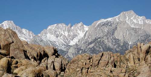
Here's the link for a blow up of the same shot:
http://c0278592.cdn.cloudfiles.rackspac ... 623036.JPG
Also, we are expecting some stormy weather this weekend so be careful.
Here's both sections of the T-Creek from the Whitney Cave area of the A-Hills last week..
Here's the link for a blow up of the same shot:
http://c0278592.cdn.cloudfiles.rackspac ... 623036.JPG
-

WML - Posts: 246
- Joined: Wed May 06, 2009 12:20 am
- Thanked: 19 times in 15 posts
The Chief wrote:It's all clear all the way up to the base of the WR. Have fun but do be advised that there will be major run off in the afternoons.
Also, we are expecting some stormy weather this weekend so be careful.
Here's both sections of the T-Creek from the Whitney Cave area of the A-Hills last week..
Here's the link for a blow up of the same shot:
http://c0278592.cdn.cloudfiles.rackspac ... 623036.JPG
Thanks, Chief. In terms of runoff, you mean the creek roaring right?
Just took a look at the latest NOAA projections for the area, and it looks like for once my days off are coinciding with the crap weather clearing out a bit. Sunday shouldn't be too windy, or rainy, my two major concerns.
On the other hand, wrangling up a partner for those days has been rough!
-
The Chief - Thanked: time in post
NWS just posted aHIGH WIND WARNING for that entire Southern Sierra/Owens Valley area beginning this eve through Sunday morning with snow above 8k through Sunday Eve.
Be careful!
Be careful!
8 posts
Page 1 of 1
-
- Related topics
- Replies
- Views
- Last post
-
- Tuttle Creek Road Closure
by dietcookie » Tue Nov 30, 2010 6:59 am - 1 Replies
- 1384 Views
- Last post by mungeclimber

Fri Dec 03, 2010 1:12 am
- Tuttle Creek Road Closure
-
- Lost Gear - Tuttle Creek :(
by Fins129 » Mon Apr 29, 2013 2:32 am - 0 Replies
- 878 Views
- Last post by Fins129
Mon Apr 29, 2013 2:32 am
- Lost Gear - Tuttle Creek :(
-
- Langley NE couloir via Tuttle Creek 4/26-4/27
by bscott » Mon Apr 21, 2014 6:56 pm - 0 Replies
- 951 Views
- Last post by bscott
Mon Apr 21, 2014 6:56 pm
- Langley NE couloir via Tuttle Creek 4/26-4/27
-
- New Routes in Pine Creek (PSOM WALL)
by Kahuna » Mon Jul 16, 2012 5:29 pm - 4 Replies
- 1866 Views
- Last post by Kahuna
Tue Jul 17, 2012 5:52 am
- New Routes in Pine Creek (PSOM WALL)
-
- Whitecliff Peak East Face/Carson Iceberg: any beta?
by Jesus Malverde » Sun Aug 28, 2011 3:23 am - 0 Replies
- 810 Views
- Last post by Jesus Malverde
Sun Aug 28, 2011 3:23 am
- Whitecliff Peak East Face/Carson Iceberg: any beta?
Who is online
Users browsing this forum: No registered users and 0 guests