
A buddy and I are looking to a two day trip out of roads end next week. I’ve been eyeing Mount Brewer. I’m thinking due to limited time - we want to stay on lower elevation and trails for the approach as long as possible. For this reason I think hiking into East Lake would be best as opposed too up Sphinx Creek and over the Col.
From East Lake looks like the plan is to do the East Ridge. Secor’s account of the route is pretty straight forward. However, he does mention when the East Ridge meets with the summit ridge to go south through a small notch. My concern is with cornices at this intersection of ridgelines.
Anyone have beta on this route? Perhaps previous spring photos or even just a few route pics at all?
Thanks in advance.
Mount Brewer - East Ridge
8 posts
Page 1 of 1
-

sharperblue - Posts: 447
- Joined: Wed Dec 06, 2006 4:05 am
- Thanked: 80 times in 58 posts
very likely not a problem; the East Ridge is very mild and the route onto the main ridge is very obvious (the notch is not mandatory either, by any means)
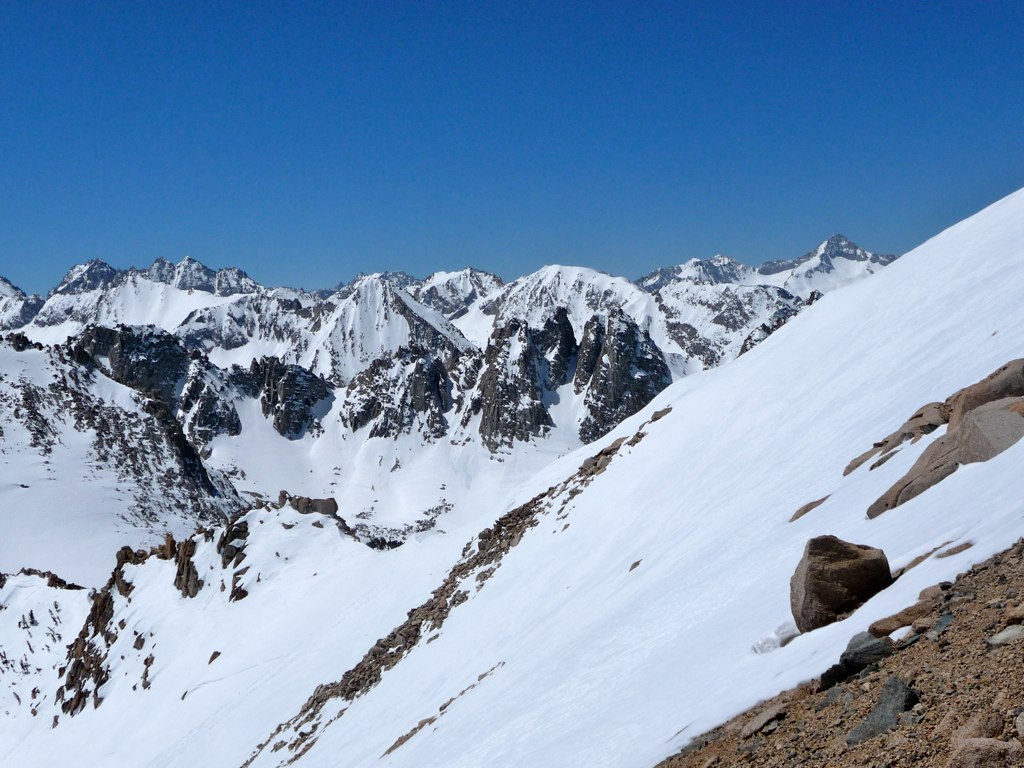
here's Brewer (middle, of course,) looking right up the East Ridge in early March a few years ago. what little snow is left by now where the ridge flattens out will be over fridge-sized stacked blocks, so look out for broken ankles; avoid by staying as close to the southern edge as possible (maybe) - good luck!
here's Brewer (middle, of course,) looking right up the East Ridge in early March a few years ago. what little snow is left by now where the ridge flattens out will be over fridge-sized stacked blocks, so look out for broken ankles; avoid by staying as close to the southern edge as possible (maybe) - good luck!
-

mrchad9 - Posts: 4545
- Joined: Thu Jul 02, 2009 12:01 am
- Thanked: 1338 times in 911 posts
Here is a photo of the top of the east ridge from Memorial Day weekend 2008. That year there was no snow to east lake, and solid snow from not too far from the base of the east ridge.
I was up Copper Creek last weekend from Roads End. There is a hell of a lot of snow up on the Sphinx Side. If you want an easier hike in east side is probably the way to go. It is very mild to get to the photo as sharperblue stated.
Also- not sure how the Bubbs creek crossing will be, but when I went the Ranger told us it couldnt be done- that horses couldnt do it. We ignored him and it was very fast, and little over knee deep, and COLD. But not an issue. If it is when you go, theres a wider, slower portion in an open area downstream.
-
sharperblue - Posts: 447
- Joined: Wed Dec 06, 2006 4:05 am
- Thanked: 80 times in 58 posts
oh right, the link  - apologies. this taken in early march with obviously much more snow cover. the south & west aspects above the 'joint' of the ridge flatten out quickly, so any cornice would be clearly visible as you approach it from below from the east.
as noted above, crossing bubbs creek will be the biggest hurdle; if memory serves, there is/was a passable tree some distance upstream a year ago
http://www.flickr.com/photos/sharperblu ... otostream/
as noted above, crossing bubbs creek will be the biggest hurdle; if memory serves, there is/was a passable tree some distance upstream a year ago
http://www.flickr.com/photos/sharperblu ... otostream/
-

Princess Buttercup - Posts: 541
- Joined: Thu Jan 11, 2007 7:13 pm
- Thanked: 456 times in 245 posts
If you do head into East Lake, stay on the slabs above Ouzel Creek (north): they all connect beautifully and probably have a good cover of snow to simply trudge all the way up. The notch of which Secor speaks isn't really obvious until you come up to the ledge system right below it. Summer views of the route are here:
http://www.flickr.com/photos/moosepics6 ... 658873000/
A few weeks ago from Kearsarge, the east ridge looked like a continuous snow climb, which could be really fun. There's some big rocks there that I was warned not to pull down on my head... Brewer is on the far right of the pic.
http://www.flickr.com/photos/moosepics6 ... 658873000/
A few weeks ago from Kearsarge, the east ridge looked like a continuous snow climb, which could be really fun. There's some big rocks there that I was warned not to pull down on my head... Brewer is on the far right of the pic.
8 posts
Page 1 of 1
-
- Related topics
- Replies
- Views
- Last post
-
- Russell East Ridge
by mtndonkey » Tue Mar 30, 2010 5:11 am - 11 Replies
- 4137 Views
- Last post by mtndonkey

Sun Apr 04, 2010 5:14 pm
- Russell East Ridge
-
- Owens Peak, east ridge?
by Sam Page » Tue Oct 13, 2009 11:17 pm - 6 Replies
- 2122 Views
- Last post by doofus
Tue Oct 20, 2009 2:08 am
- Owens Peak, east ridge?
-
- Mt. Williamson, East Ridge
by Sam Page » Tue Dec 15, 2009 5:25 am - 6 Replies
- 2644 Views
- Last post by yaknjorgl
Wed Dec 16, 2009 5:58 pm
- Mt. Williamson, East Ridge
-
- Descent from LPP, SF and East Ridge
by Blair » Tue Dec 22, 2009 2:18 am - 1 Replies
- 1156 Views
- Last post by peterh
Tue Dec 22, 2009 9:27 pm
- Descent from LPP, SF and East Ridge
-
- East Ridge Lone Pine Peak
by Blair » Mon Feb 07, 2011 4:31 pm - 6 Replies
- 2522 Views
- Last post by Blair
Sun Feb 13, 2011 12:52 am
- East Ridge Lone Pine Peak
Who is online
Users browsing this forum: No registered users and 0 guests