Old Army Pass or New Army Pass?
-

Mescalito345 - Posts: 94
- Joined: Sun Apr 24, 2005 4:32 pm
- Thanked: 6 times in 3 posts
Old Army Pass or New Army Pass?
In September 2006, I hiked to Mt. Langley via Old Army Pass. This year, I'm going much earlier in the season (June 19-20). What's the standard route at this time of year? I've heard different opinions about which of the two routes is better. Our group will be staying at Cottonwood Lakes on June 19, with a summit attempt on June 20.
-
Mescalito345 - Posts: 94
- Joined: Sun Apr 24, 2005 4:32 pm
- Thanked: 6 times in 3 posts
Thanks, Vitaliy. I might try that route sometime. Any special gear required, besides ice axe and crampons?
For this trip, I already have 6 wilderness permits for the Cottonwood Lakes area, so I'm trying to figure out the best way to get to the ridgeline leading to Langley.
For this trip, I already have 6 wilderness permits for the Cottonwood Lakes area, so I'm trying to figure out the best way to get to the ridgeline leading to Langley.
-

simonov - Posts: 1395
- Joined: Thu Mar 23, 2006 3:07 pm
- Thanked: 786 times in 451 posts
The entire purpose of New Army Pass is to provide access when snow in (Old) Army Pass makes it impassible or dangerous. Last August, there was enough snow in (Old) Army Pass that I was obliged to lead a group through New Army Pass. I haven't been in the Sierra since January, but I believe there is even more snowpack this year. Unless you hear different from someone who has actually been there this year, I suspect you will be obliged to use New Army Pass.
Accessibility being equal, (Old) Army Pass is by far the preferred route. It is shorter than New Army Pass, and the latter adds something like 600 feet to the climb. On the other hand, that extra mileage and elevation gives you this view of the route up Langley, which you don't get from (Old) Army Pass (the top of which is at the lower right of this photo):
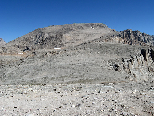
There is more information about the route in the caption to that photo (click on it).
Edit: looks like you are getting more complete advice in your thread on the Whitney Portal Board.
Accessibility being equal, (Old) Army Pass is by far the preferred route. It is shorter than New Army Pass, and the latter adds something like 600 feet to the climb. On the other hand, that extra mileage and elevation gives you this view of the route up Langley, which you don't get from (Old) Army Pass (the top of which is at the lower right of this photo):
There is more information about the route in the caption to that photo (click on it).
Edit: looks like you are getting more complete advice in your thread on the Whitney Portal Board.
-

The Chief - Thanked: time in post
I guarantee ya that the South aspect of Langley will even come close to looking anything like that photo'd above in two weeks. According to most snow surveys throughout the Southern Sierra, there's still a good 24" of base snow with drifts upwards of 60" if not more, in many shady locations above 10K'.
Both Old and New Army Passes will be heavily snow & ice laden in two to three weeks...guaranteed!
These conditions won't change all that much in two weeks. Something that the OPer needs to seriously consider in their planning for this trip.
-
Mescalito345 - Posts: 94
- Joined: Sun Apr 24, 2005 4:32 pm
- Thanked: 6 times in 3 posts
I've already hiked/climbed Langley on a dry trail, so this time I wanted to climb it in the snow. That's why I picked a date in the spring, instead of late summer. Everyone in our group will have ice axe and crampons.
There seem to be differing opinions about NAP and AP, so I guess we should just prepare for both, and discuss the routes with other hikers at Cottonwood Lakes on June 19.
There seem to be differing opinions about NAP and AP, so I guess we should just prepare for both, and discuss the routes with other hikers at Cottonwood Lakes on June 19.
-

EManBevHills - Posts: 522
- Joined: Sun Feb 06, 2005 3:55 pm
- Thanked: 2 times in 1 post
FWIW, there was a fatality last year on a descent of OAP in late July...
The area near the top of the pass is likely to remain quite sketchy well into the summer this year, given the snowpack. As I recall, it is easy to underestimate the risk there. The additional elevation gain via NAP is well worth the piece of mind as it is a much safer route.
The area near the top of the pass is likely to remain quite sketchy well into the summer this year, given the snowpack. As I recall, it is easy to underestimate the risk there. The additional elevation gain via NAP is well worth the piece of mind as it is a much safer route.
-
Mescalito345 - Posts: 94
- Joined: Sun Apr 24, 2005 4:32 pm
- Thanked: 6 times in 3 posts
Thanks, I've read the reports about the OAP fatality. Not sure about the details, but the victim appeared to be a hiker who tried to traverse a steep icy section, without ice axe or crampons.
-
The Chief - Thanked: time in post
EManBevHills wrote:FWIW, there was a fatality last year on a descent of OAP in late July...
The area near the top of the pass is likely to remain quite sketchy well into the summer this year, given the snowpack. As I recall, it is easy to underestimate the risk there. The additional elevation gain via NAP is well worth the piece of mind as it is a much safer route.
The victim NEVER finished ascending icy OAP snow field. She got scared on the ascent, the rest of her party went onto the summit and told her to stay put approx 3/4ers of the way up the snow/ice field, she got ansy waiting for her party to return from the summit and she decided to descend on her own. She began her descent WITHOUT an Ice Axe nor Crampons, lost her footing on the ice, and zipped head first some 300 feet uncontrolled and then impacted a large boulder and died instantly. The returning party was met with the traumatic results. They left her body in place and reported the incident. Took a day and half to get a helo in to recover her remains.
This incident occurred the day after my client died of HAPE down below on the approach trail.
-

Brian Frederick - Posts: 95
- Joined: Mon Aug 02, 2004 9:05 pm
- Thanked: 1 time in 1 post
The one time I went up Old Army in the late spring there was quite a cornice that we had to burrow through.
-
EManBevHills - Posts: 522
- Joined: Sun Feb 06, 2005 3:55 pm
- Thanked: 2 times in 1 post
Chief, I beg to differ with you.
Mark & I chatted for a few minutes with Janice above OAP on our ascent. She even gave Mark an Advil.
We discussed the conditions she experienced on the way up to the pass, and she mentioned how much she had enjoyed the scrambling! She even suggested that we could descend it safely ourselves, even without having ascended it.....
Janice had a book with her, and did not have an iota of summit fever. She was truly content to savor the day.
I looked at OAP twice, once before meeting her, and once after (on our descent), and elected to return NAP. Here was the view on our way up:
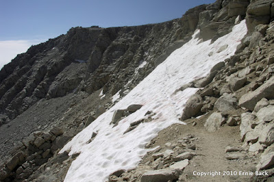
We had no idea about the accident until I read of it several days later.
Mark & I chatted for a few minutes with Janice above OAP on our ascent. She even gave Mark an Advil.
We discussed the conditions she experienced on the way up to the pass, and she mentioned how much she had enjoyed the scrambling! She even suggested that we could descend it safely ourselves, even without having ascended it.....
Janice had a book with her, and did not have an iota of summit fever. She was truly content to savor the day.
I looked at OAP twice, once before meeting her, and once after (on our descent), and elected to return NAP. Here was the view on our way up:
We had no idea about the accident until I read of it several days later.
-

jbetoo - Posts: 40
- Joined: Tue Feb 15, 2005 10:34 pm
- Thanked: 1 time in 1 post
If you are climbing Langley, Old Army Pass is more direct. If you're mountaineering skills are sharp, it's the preferred route. But if you're hiking up and over the pass to the PCT, then Old Army Pass wouldn't be worth the trouble, IMO. New Army Pass is pretty cool, too.
-
Mescalito345 - Posts: 94
- Joined: Sun Apr 24, 2005 4:32 pm
- Thanked: 6 times in 3 posts
Thanks for all of the responses. Most likely, we will take the main chute up to Old Army Pass. I found the following links on SummitPost:
http://www.summitpost.org/view_object.php?object_id=53389
http://www.summitpost.org/view_object.php?object_id=21916&context_id=150246
http://www.summitpost.org/image/7147/150246/the-way-up-old-army-pass-we.html
http://www.summitpost.org/view_object.php?object_id=53389
http://www.summitpost.org/view_object.php?object_id=21916&context_id=150246
http://www.summitpost.org/image/7147/150246/the-way-up-old-army-pass-we.html
-
The Chief - Thanked: time in post
EManBevHills wrote:Chief, I beg to differ with you.
Mark & I chatted for a few minutes with Janice above OAP on our ascent. She even gave Mark an Advil.
We discussed the conditions she experienced on the way up to the pass, and she mentioned how much she had enjoyed the scrambling! She even suggested that we could descend it safely ourselves, even without having ascended it.....
Janice had a book with her, and did not have an iota of summit fever. She was truly content to savor the day.
I looked at OAP twice, once before meeting her, and once after (on our descent), and elected to return NAP. Here was the view on our way up:
We had no idea about the accident until I read of it several days later.
Just passing on the story that the Inyo SAR DIC shared with me regarding this particular sad incident the day after as I was writing my Incident Report for my incident at the Lone Pine Inyo Sheriff Substation.
If you in fact ran into her that day, you must of passed the location of my incident that morning or the day before as well. When did you all hike in?
-
EManBevHills - Posts: 522
- Joined: Sun Feb 06, 2005 3:55 pm
- Thanked: 2 times in 1 post
Same day, Chief. I had expected (and was looking forward) to meeting you in the flesh. When we came upon a group on our descent, we asked if you were with them. The female guide knew Mark from a prior hike on Whitney, and filled him in about the incident you had dealt with earlier in the day...
-

skotty - Posts: 171
- Joined: Fri Jul 12, 2002 7:25 pm
- Thanked: 0 time in 0 post
The image links above look like pretty heavy snow pack, probably a good example of what is going to be up there in next few weeks.
Chief, Eman, were the conditions anything like that during the fatal incident or was it thinner and more iced up? With a snow pack like that shown in the pics linked above, its hard to imagine not being able to easily plunge step up and down.
I'm thinking of taking a group of newbies up NAP or OAP July 10. I'll bring a rope and a picket or two if I have to, but with such heavy snow its hard to imagine it being necessary. Though I've only done it dry so maybe I'm mistaken. What do you think?
-
- Related topics
- Replies
- Views
- Last post
-
- Old Army Pass
by peninsula » Thu Aug 26, 2010 2:46 pm - 8 Replies
- 3862 Views
- Last post by Kapelmuur

Wed Sep 22, 2010 4:35 am
- Old Army Pass
-
- Camp on New Army Pass
by yang » Tue Jul 29, 2014 6:56 am - 9 Replies
- 3565 Views
- Last post by colinr
Sun Aug 03, 2014 1:41 am
- Camp on New Army Pass
-
- Old Army Pass conditions
") by rmca » Tue Jun 25, 2013 3:41 am
by rmca » Tue Jun 25, 2013 3:41 am
- 9 Replies
- 6333 Views
- Last post by BobEnein
Sun Jun 07, 2020 1:54 am
- Old Army Pass conditions
-
- Mt. Langley- New or Old Army Pass?
by SurfinPeakScience » Tue Sep 13, 2011 6:51 pm
- 6 Replies
- 5439 Views
- Last post by calicokat
Thu Sep 15, 2011 9:31 pm
- Mt. Langley- New or Old Army Pass?
-
- Cottonwood Lakes/New Army Pass conditions?
1, 2by Funyan005 » Tue Apr 24, 2012 5:57 pm - 26 Replies
- 8813 Views
- Last post by Peter50
Mon Jun 11, 2012 11:32 am
- Cottonwood Lakes/New Army Pass conditions?
Who is online
Users browsing this forum: No registered users and 0 guests