Need Advice - How steep is too steep?

Post general questions and discuss issues related to climbing.
User Avatar
Bill Reed

 
Posts: 534
Joined: Thu Apr 21, 2005 4:46 pm
Thanked: 78 times in 59 posts

Need Advice - How steep is too steep?

by Bill Reed » Tue Apr 26, 2011 2:08 am

I sometimes study maps looking for routes and often, though not always, I find one that's doable. Looking at this snowfield as a route to the top of the ridge and wondered if any experienced snow-climbing SPers might offer an opinion on its feasibility.
Image
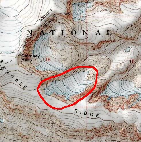
The last 600+ feet look pretty damn steep to me but I can't help thinking it might be possible. I'm probably a 1 on a scale of 1-5 in terms of experience with steep snow, having taken a course on self arrest and basic snow skills but with only 1 similar climb (Andrews Glacier in RMNP) on my resume.
One of the voices in my head says, "You can do it, just start early and move cautiously." Another says, "It's too steep, hone your skills a bit more before you tackle this one, fool!"

Should I pursue this or save it for another day?

Appreciate any input you might have.
Thanks!!
Bill

User Avatar
SKI

 
Posts: 275
Joined: Sat Jan 10, 2009 2:52 pm
Thanked: 47 times in 27 posts

Re: Need Advice - How steep is too steep?

by SKI » Tue Apr 26, 2011 2:39 am

It's pretty hard to tell from here without the map in front of me. I would say that the final exit is close to maybe 45-50 degrees. Not too bad man, go for it. It's never as steep as it looks from afar up close.

Remember, each contour line represents 40 feet in elevation difference and each contour interval is (on most maps) 200 ft.

The following user would like to thank SKI for this post
Bill Reed

User Avatar
Princess Buttercup

 
Posts: 541
Joined: Thu Jan 11, 2007 7:13 pm
Thanked: 456 times in 245 posts

Re: Need Advice - How steep is too steep?

by Princess Buttercup » Tue Apr 26, 2011 4:31 am

I knew I had a small plastic tool I picked up a while back at REI that helped measure slope angle from topo maps. Little piece of plastic, to be used on 1:24K maps. Called a "Topo Scale", it should give you an idea of the slope angle based on the topo lines themselves. Good place to start.

Then again, you also have to consider snowpack, wind patterns/loading, and a whole slew of other factors (including the runout should you slip and have to self-arrest. A lot comes into play once you've actually reached the destination and can see everything for yourself first-hand.

But as I said, the Topo Scale is a great place to start.

Hope this helps,

Laura

The following user would like to thank Princess Buttercup for this post
Bill Reed

User Avatar
dadndave
Forum Moderator
 
Posts: 15076
Joined: Mon Nov 22, 2004 12:21 am
Thanked: 2002 times in 1325 posts

Re: Need Advice - How steep is too steep?

by dadndave » Tue Apr 26, 2011 12:35 pm

Looks extremely steep at the top of the gully, I can't work in feet, but I'd say there's an almost a headwall at the top of that.
The strawman is evil and must be punished,

The following user would like to thank dadndave for this post
Bill Reed

User Avatar
Charles

 
Posts: 14939
Joined: Fri Jan 09, 2004 9:20 am
Thanked: 1171 times in 865 posts

Re: Need Advice - How steep is too steep?

by Charles » Tue Apr 26, 2011 2:53 pm

MooseTracks wrote:I knew I had a small plastic tool I picked up a while back at REI that helped measure slope angle from topo maps. Little piece of plastic, to be used on 1:24K maps. Called a "Topo Scale", it should give you an idea of the slope angle based on the topo lines themselves. Good place to start.
Laura

Yes I´ve got one with the 2 usual scales on it (for us) 1:25.000 and 1:50000, very useful, especialy for checking steepnes in relation to avalanche conditions.

The following user would like to thank Charles for this post
Bill Reed

User Avatar
surgent

 
Posts: 545
Joined: Wed Aug 20, 2003 2:45 pm
Thanked: 143 times in 80 posts

Re: Need Advice - How steep is too steep?

by surgent » Tue Apr 26, 2011 3:07 pm

Steepness is one thing, but the composition of the slope is another. If it's big chunky talus, you can still worm your way up ... probably ... without advanced climbing skills. As they say, there's only one way to find out.

Topo maps with the 40-foot subcountours can still hide barriers 20, 30 and theoretically 39.999... feet tall. Looking at the map you provided, could you gain the ridge farther east instead of one of those ribs shown encircling the glacier/snow field?

User Avatar
chugach mtn boy

 
Posts: 942
Joined: Sat Jun 10, 2006 7:54 pm
Thanked: 224 times in 129 posts

Re: Need Advice - How steep is too steep?

by chugach mtn boy » Tue Apr 26, 2011 3:56 pm

If those are one-mile gridlines on that map, the last 400 vertical feet of that slope occurs in 400 horizontal feet, which means the slope is 1:1 or 45 degrees. Might be a litte steeper than that right at the top, but you can't really rely on a topo to give you the fine gradations.

The following user would like to thank chugach mtn boy for this post
Bill Reed

User Avatar
AlexeyD

 
Posts: 2081
Joined: Thu Jun 06, 2002 11:13 am
Thanked: 60 times in 48 posts

Re: Need Advice - How steep is too steep?

by AlexeyD » Tue Apr 26, 2011 9:24 pm

I would suggest trying Google Earth - depending on the quality of the images for that area, it might give you a better picture of the nature of the terrain you're interested in.

Also, if this is indeed a glacier, as it is marked on the map, I might be a bit concerned about the possibility of a bergschrund or moat on a steep headwall like that.

The following user would like to thank AlexeyD for this post
Bill Reed

User Avatar
phlipdascrip

 
Posts: 221
Joined: Tue May 05, 2009 5:13 pm
Thanked: 23 times in 16 posts

Re: Need Advice - How steep is too steep?

by phlipdascrip » Wed Apr 27, 2011 1:37 am

I don't know anything about the area and I don't think this will help you much either but for what it's worth:
http://maps.google.com/maps?ll=43.17614 ... oramio.all

I'm guessing the snowfield and glacier at the very right of this picture is what you're talking about?
http://v1.cache4.c.bigcache.googleapis. ... 384459.jpg
Also
http://v7.cache3.c.bigcache.googleapis. ... 384423.jpg

The following user would like to thank phlipdascrip for this post
Bill Reed

User Avatar
Bill Reed

 
Posts: 534
Joined: Thu Apr 21, 2005 4:46 pm
Thanked: 78 times in 59 posts

Re: Need Advice - How steep is too steep?

by Bill Reed » Wed Apr 27, 2011 2:32 am

First of all, thanks for all the replies!! Lots of good advice and thought provoking questions.

Going backwards to respond,
Hope that's not the snowfield in question. Not enough snow to call it a field - Damn Global Warming!
Have looked at 3D Google Earth and get the same feel-Doable but very steep near the top. It is a snowfield not a glacier, so don't think crevasses or bergschrunds are an issue.
I'm going there anyway but the side issue is: Should I carry the extra weight: axe, crampons and helmet?
Judging by the 3D Google Earth view, I'm guessing it to be steeper than 45 degrees at the top.
The snowfields and couloirs to the east seem to peter out before reaching the ridgetop, though a couple look interesting.
I'll have to look for one of those Topo Scales next time I head over to REI. Sounds like a good tool to have.
I hope there's not a headwall at the top, don't see it on Google Earth, but I suppose I'll have to check it out up close.


I'm thinking I could compare the Topo contours to something I'm familiar with, something closer to home. Also thinking I could find something similar to try to climb close to home, before this trip - probably the wisest move.
Lastly, if I think it's possible, I can carry the equipment and try it. If it doesn't look like something I want to tackle, I can at least work on my skills on the less steep, lower slopes of the snowfield.

Thanks again and know that I will post the results when it's all said and done.

User Avatar
MarkDidier

 
Posts: 380
Joined: Tue Jul 01, 2008 2:24 am
Thanked: 67 times in 48 posts

Re: Need Advice - How steep is too steep?

by MarkDidier » Wed Apr 27, 2011 2:37 am

Horse Ridge? I assume it's for your trip to the Winds this year! Good luck and be safe. Anxiously awaiting your TR.

no avatar
sneakyracer

 
Posts: 238
Joined: Fri Aug 28, 2009 12:52 am
Thanked: 13 times in 11 posts

Re: Need Advice - How steep is too steep?

by sneakyracer » Wed Apr 27, 2011 3:23 am

If there is snow, you will need crampons and an ice axe at anything steeper than 20-25deg. For low angle stuff Kahtoola Microspikes work well. But that area looks steep.

You need to be ready for hard, icy snow and changing conditions at those altitudes. It basically still winter above 12k FT in the rockies. And that far north, maybe 10K. Melt-Freeze cycles are posible up high, certain down low but be vigilant for bad, layered winter type snow quality any time.

Also, most NE facing slopes have notoriously large cornices up high due to prevailing west and even southwest winds in the rockies during storm cycles.

So basically, this time of year, you need to be ready for anything so if it were me, id take winter gear.

The following user would like to thank sneakyracer for this post
Bill Reed

User Avatar
brenta

 
Posts: 1978
Joined: Fri Aug 13, 2004 1:43 am
Thanked: 20 times in 16 posts

Re: Need Advice - How steep is too steep?

by brenta » Wed Apr 27, 2011 7:12 am

Bill Reed wrote:Hope that's not the snowfield in question.

Bill, I'm afraid phildascrip is right. The picture and the maps seem to match very well. I spent some inconclusive time yesterday night looking at the area in Google Maps. I got the impression that the tundra atop the ridge suddenly gave way to a drop off to the east. The pictures seem to confirm that.
Bill Reed wrote:don't think crevasses or bergschrunds are an issue.

There may still be a moat at the top of the snowfield. Besides, the rock that is periodically covered and uncovered by the snow may have been churned to the point that it poses a significant hurdle.
Bill Reed wrote:Should I carry the extra weight: axe, crampons and helmet?

I definitely would.
Bill Reed wrote:I'm guessing it to be steeper than 45 degrees at the top.

Agreed.
Bill Reed wrote:I could find something similar to try to climb close to home

Maybe Dragontail?

Anyway, the area looks gorgeous. I wish you a great trip.

The following user would like to thank brenta for this post
Bill Reed

User Avatar
Bill Reed

 
Posts: 534
Joined: Thu Apr 21, 2005 4:46 pm
Thanked: 78 times in 59 posts

Re: Need Advice - How steep is too steep?

by Bill Reed » Wed Apr 27, 2011 2:01 pm

Thanks again! I'll look at Dragontail, Brenta, good suggestion. Phildascrip, where you find those photos?

User Avatar
phlipdascrip

 
Posts: 221
Joined: Tue May 05, 2009 5:13 pm
Thanked: 23 times in 16 posts

Re: Need Advice - How steep is too steep?

by phlipdascrip » Wed Apr 27, 2011 3:49 pm

Bill Reed wrote:Phildascrip, where you find those photos?

They're on Panoramio which is linked with google maps and earth; you can enable the option to show photos in both (see my link to google maps - http://maps.google.com/maps?ll=43.17614 ... oramio.all ). I just opened a few and clicked around in that Panoramio user's nearby images and tried to match the photos to the terrain map. You can view the pics in full size on that site too.
In a couple of years there will probably be many more useful geo-tagged photos on the web that will help with such things.

Next

Return to General


  • Related topics
    Replies
    Views
    Last post

Who is online

Users browsing this forum: ashbal and 0 guests

cron