Cunningham Creek and Longley Pass
13 posts
Page 1 of 1
-

peninsula - Posts: 1724
- Joined: Fri Mar 18, 2005 8:10 am
- Thanked: 81 times in 54 posts
Cunningham Creek and Longley Pass
I'm looking for any advice on approaching Longley Pass from Cloud Canyon via Cunningham Creek. I'll be entering Cloud Canyon via Colby Pass. Also, suggestions regarding scenic campsites between Colby Pass and Cunningham Cr are welcome. Thanks!!
-

thegib - Posts: 174
- Joined: Tue Jan 24, 2006 7:18 pm
- Thanked: 27 times in 21 posts
Re: Cunningham Creek and Longley Pass
As you descend from Colby lake, if you just turn south and march up canyon, immediately east of Whaleback, it's all open and lovely. I camped at 10400 and loved it. Climb Whaleback while you're at it, beautiful ridge. What I remember from ascending Cunningham Ck is mosquitos, sun, and brush. Ugh. Another route, which I heartily recommend, is to more closely parallel the GWD. Head north from Colby lake, follow the creek to Talus lake, go north to Table ck and pass just west of Thunder Mtn at 12000', then descend to around 11000 on Cunningham ck. I did this (w/GF) the other direction, which I think is preferable, but still super cool. Have a great time!
-
peninsula - Posts: 1724
- Joined: Fri Mar 18, 2005 8:10 am
- Thanked: 81 times in 54 posts
Re: Cunningham Creek and Longley Pass
thegib wrote:As you descend from Colby lake, if you just turn south and march up canyon, immediately east of Whaleback, it's all open and lovely. I camped at 10400 and loved it. Climb Whaleback while you're at it, beautiful ridge. What I remember from ascending Cunningham Ck is mosquitos, sun, and brush. Ugh. Another route, which I heartily recommend, is to more closely parallel the GWD. Head north from Colby lake, follow the creek to Talus lake, go north to Table ck and pass just west of Thunder Mtn at 12000', then descend to around 11000 on Cunningham ck. I did this (w/GF) the other direction, which I think is preferable, but still super cool. Have a great time!
Thanks thegib, sounds great! Thanks for the feedback, I'll study your route via Talus Lake. Won't be in the area until the first week of October, so at least I can avoid the mosquitos.
-
peninsula - Posts: 1724
- Joined: Fri Mar 18, 2005 8:10 am
- Thanked: 81 times in 54 posts
Re: Cunningham Creek and Longley Pass
Last year's effort was aborted due to an early-winter storm. I'm going to try again this year, and while in the region, I'm interested in visiting Josephine Lake. Any advice on the best approach to this lake is appreciated... it looks steep from most angles!
-
peninsula - Posts: 1724
- Joined: Fri Mar 18, 2005 8:10 am
- Thanked: 81 times in 54 posts
Re: Cunningham Creek and Longley Pass
peninsula wrote:Last year's effort was aborted due to an early-winter storm. I'm going to try again this year, and while in the region, I'm interested in visiting Josephine Lake. Any advice on the best approach to this lake is appreciated... it looks steep from most angles!
I have my route pretty much figured out now, and I'm ruling out a visit to Josephine Lake. Instead, I plan to go over Longley Pass with a west-side approach. Any advice on the best route to descend on the East side of Longley Pass with an aim for Colby Pass is appreciated... I'm concerned about the steep sections between 12 and 11,000 feet. I want to get down to Cunningham Creek, should I vere towards South Guard Lake or veer more to the south as I make my way to Cunningham Creek? Thank you in advance!
-
thegib - Posts: 174
- Joined: Tue Jan 24, 2006 7:18 pm
- Thanked: 27 times in 21 posts
Re: Cunningham Creek and Longley Pass
It's easy to descend to S. Guard lake from Longley. On the Tom Harrison map it may look like a steep 4-600' section, but it's a non-issue. Did it with packs, in the rain, with trepidatious GF, two weeks ago.
-
peninsula - Posts: 1724
- Joined: Fri Mar 18, 2005 8:10 am
- Thanked: 81 times in 54 posts
Re: Cunningham Creek and Longley Pass
thegib wrote:It's easy to descend to S. Guard lake from Longley. On the Tom Harrison map it may look like a steep 4-600' section, but it's a non-issue. Did it with packs, in the rain, with trepidatious GF, two weeks ago.
Thanks thegib. My once trepidatious girlfriend is now my wife of 25 years! Needless to say, she stopped joining me on my backpacking expeditions soon after I purchased said cow.
Cheers!
-

finckster - Posts: 29
- Joined: Tue Jun 30, 2009 5:12 am
- Thanked: 4 times in 4 posts
Re: Cunningham Creek and Longley Pass
I recall that navigating the lower sections of Cunningham Creek was much more challenging than Longley Pass itself, but totally doable. After the tarn above South Guard Lake, I stayed high in order to get around the lake. Below that, there are two steeper sections on the way down, one near a waterfall and one just above the canyon floor. You can probably get through both of them on either side of the creek; I was on the south side for the first one and the north for the lower one, but don't know that these were the better choices.
Really beautiful area and I didn't see a soul. Some photos below but more are here: https://picasaweb.google.com/lh/photo/ACs4psNXymndb8tXg4x7O9MTjNZETYmyPJy0liipFm0?feat=directlink
Getting aroung South Guard Lake:
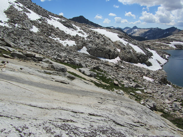
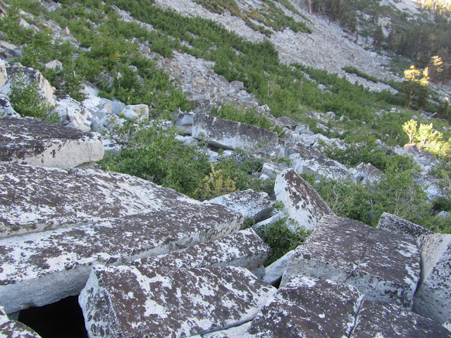
Loose brushy talus:
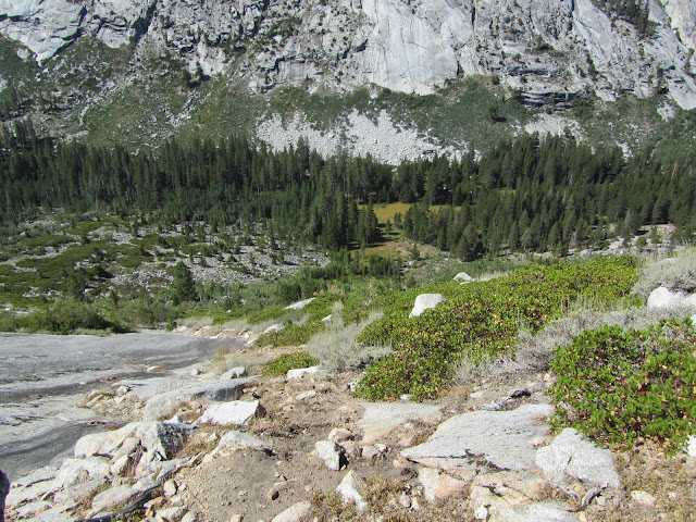
Final stretch above Cloud Canyon:
Really beautiful area and I didn't see a soul. Some photos below but more are here: https://picasaweb.google.com/lh/photo/ACs4psNXymndb8tXg4x7O9MTjNZETYmyPJy0liipFm0?feat=directlink
Getting aroung South Guard Lake:
Loose brushy talus:
Final stretch above Cloud Canyon:
-

boyblue - Posts: 191
- Joined: Sat Feb 15, 2003 9:30 am
- Thanked: 111 times in 66 posts
Re: Cunningham Creek and Longley Pass
finckster wrote:I recall that navigating the lower sections of Cunningham Creek was much more challenging than Longley Pass itself, but totally doable. After the tarn above South Guard Lake, I stayed high in order to get around the lake. Below that, there are two steeper sections on the way down, one near a waterfall and one just above the canyon floor. You can probably get through both of them on either side of the creek; I was on the south side for the first one and the north for the lower one, but don't know that these were the better choices.
I descended Cunningham in 1979. A cliff with a waterfall blocks progress at about the 10,300 foot level. finckster is right (nice pictures, btw
-
peninsula - Posts: 1724
- Joined: Fri Mar 18, 2005 8:10 am
- Thanked: 81 times in 54 posts
Re: Cunningham Creek and Longley Pass
Thanks finckster and boyblue! I appreciate the area photos... they have me getting excited about the trip. I'll be leaving for Lone Pine Sunday and packing in on Monday. I've decided to take thegib's high route and avoid the steepness encountered along the lower reaches of Cunningham Creek. The higher route makes sense as I'll be going over Colby Pass. Originally, I thought I might make my way to Josephine Lake, but I've ruled out that campsite for this trip... perhaps another day. It's going to be awesome!
Trip itinerary: http://mapshare.delorme.com/Consumer/V.aspx?p=l1cvm7fm
Trip itinerary: http://mapshare.delorme.com/Consumer/V.aspx?p=l1cvm7fm
-
peninsula - Posts: 1724
- Joined: Fri Mar 18, 2005 8:10 am
- Thanked: 81 times in 54 posts
Re: Cunningham Creek and Longley Pass
butitsadryheat wrote:Nice trip ya got planned peninsula. I like that software you have your trip planned on too. Can't wait to see the pics when you get back. Be safe
Thanks butitsadryheat. This is my first year using Delorme and I like it a lot. I've posted some of my impressions using Delorme under the following link:
gps-recommendations-t61509.html
Delorme's "MapShare" features are impressive, not to mention the rest of their hardware and software products.
-
peninsula - Posts: 1724
- Joined: Fri Mar 18, 2005 8:10 am
- Thanked: 81 times in 54 posts
Re: Cunningham Creek and Longley Pass
Finally, I finished the trip report; my thanks go out to all of those who helped in the planning: http://www.summitpost.org/view_object.p ... irm_post=7
13 posts
Page 1 of 1
-
- Related topics
- Replies
- Views
- Last post
-
- Conditions for Italy Pass, Pine Creek Pass, Treasure Col?
by Teresa Gergen » Tue May 20, 2014 6:57 pm - 3 Replies
- 2857 Views
- Last post by Teresa Gergen

Wed May 28, 2014 5:34 am
- Conditions for Italy Pass, Pine Creek Pass, Treasure Col?
-
- Pine Creek - Italy Pass Trail
by KTudhope » Mon Jul 11, 2011 10:23 pm - 9 Replies
- 7316 Views
- Last post by KathyW
Tue Aug 02, 2011 9:20 pm
- Pine Creek - Italy Pass Trail
-
- Horse Creek Pass / Matterhorn Peak Conditions
") by birdhead » Sat Jun 16, 2012 9:46 pm
by birdhead » Sat Jun 16, 2012 9:46 pm
- 13 Replies
- 5666 Views
- Last post by WillyTheDog
Tue Sep 04, 2012 10:47 am
- Horse Creek Pass / Matterhorn Peak Conditions
-
- Piscator Peak, Fish Creek Region, Silver Pass
by asmrz » Fri Jul 27, 2012 7:03 pm - 5 Replies
- 3014 Views
- Last post by asmrz
Fri Aug 03, 2012 10:41 pm
- Piscator Peak, Fish Creek Region, Silver Pass
-
- Bear Creek Spire - Rock Creek Road?
1, 2 by Burchey » Wed Feb 27, 2013 8:03 pm
- 28 Replies
- 16577 Views
- Last post by BHunewill
Sun May 05, 2013 10:36 pm
- Bear Creek Spire - Rock Creek Road?
Who is online
Users browsing this forum: No registered users and 0 guests