Looks like I'm trading in the piolet for the paddle for awhile..
Hey, anybody have any info on hiking/hiking trails on Ilsa Espirtu Santo in Baja? Is hiking even allowed because it's a protected area?
Specially, is the island highpoint hike-able or even accessible ?
http://www.peakbagger.com/peak.aspx?pid=14775
There doesn't seem to be much of any information out there on the web..
I did find this, but it's not much help on the highpoint question:
http://www.bajainsider.com/baja-califor ... iasur.html
I'd appreciate any information you might share.
Best,
JM
Isla Espíritu Santo's highpoint, accessible? (Baja)
3 posts
Page 1 of 1
-

Jesus Malverde - Posts: 380
- Joined: Wed Nov 14, 2001 1:17 pm
- Thanked: 140 times in 90 posts
Re: Isla Espíritu Santo's highpoint, accessible? (Baja)
Howdy folks,
As no one answered my original post, I thought I'd update it with some information that I obtained. Unfortunately due to time constraints I wasn't able to attempt the Isla Espiritu Santo (IES) highpoint, but I am posting the info here in case some kayaking aventurero/a needs to feed the inner mountaineer whilst water-bound around the Isla.
I spoke with a local kayak guide about the IES summit and she said that the rock quality is poor and that you need "need a rope" for the last section of the summit. FWIW, it sounded like she hadn't been to the top and needing a rope really could mean anything from easy class 3 (but possibly intimidating for the non-climber) to an actual, short technical pitch. From the view I saw from the east side of the Isla, it didn't look like there was much of a summit block. Google Earth didn't show much of a summit block either from what I could tell. It's possible she was trying to discourage me from doing any x-country travel on the island. Who knows?...Hell, one more good reason to strive, to seek, to find and not to yield.
There seems to be two starting points to climbing the highpoint. Both places have beautiful camping beaches.
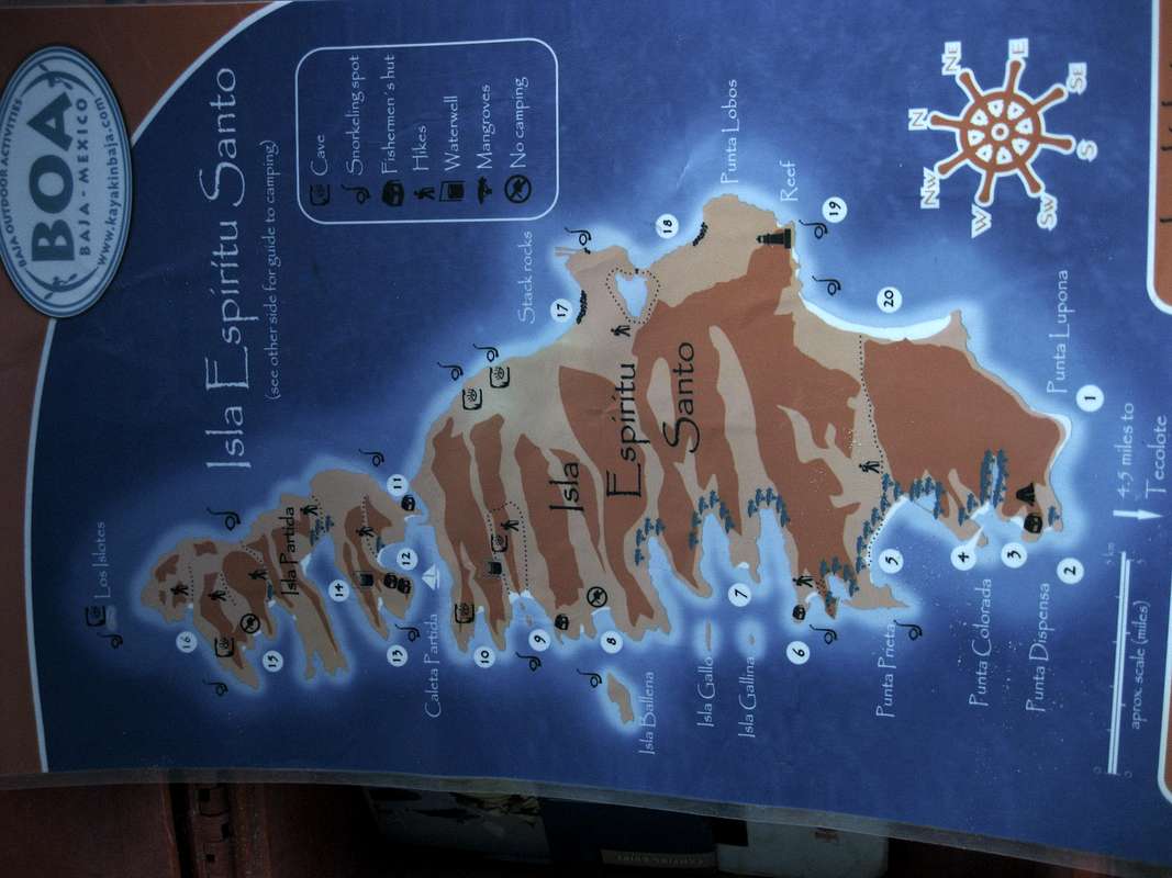
1. The Point between Isla Partida and Isla Espirtu Santo, aka Playa Partida. Here's a description of this area care of Baja Outdoor Activites IES boating/kayaking map: "There are two sand bars in the channel between channel between Isla Partida and Isla Espirtu Santo. On the northeast bar, up against the cliff, there is good camping. The huge crater walls that surround this area and the vast expanse of shallow water provide a spectacular view, and one can easily imagine how Partida and Espiritu Santo were one land mass before this volcanic crater was breached by the sea. It is possible to paddle though the channel to the east side of the island even at low tide."
Note if you go this route, you will have to climb over the first ridge and likely down into a gulley/wash/canyon before accessing the next ridge to get up on the massif proper. I'm guessing this might take at least 3-4 hours one way from a Playa Partida camp. Note, there are two small fishing camps at Playa Partida, one on the Partida side and one on the Espiritu Santo side. There is also a park ranger "shack" on the IES side, if you are interested in the Juanito Law presence. Word on the beach was that the park rangers did not use the park hut very often.
2. Candelero. Here's a description of this area care of BOA once again: "Two stunning beaches with a spectacular ridge that splits the bay in half. It is easily identified by the small islands in the bay that make great areas for snorkeling. A 10 minute hike behind the northern leads to a well were you can rinse with 'fresh' water and a further 10 minute hike and you arrive at a dry waterfall, wild fig trees and spectacular over-hanging rocks." The BOA IES kayaking map shows two west-to-east trails from Candelero. One trail starts on the north side of the beach and one starts on the south side. Both trails join a little under half way across the island. FWIW, it looks like the south trail gets you closest to the highpoint. Obviously you will be doing some off-trail hiking when the trail runs out.
Is off-trail hiking allowed on Isla Espiritu Santo?
Here is the official webpage for Parque Nacional Archipiélago de Espíritu Santo
http://pnaes.conanp.gob.mx/
"caminando a través de los senderos autorizados"
walking across the authorized paths
Also:
COMISIÓN NACIONAL DE ÁREAS NATURALES PROTEGIDAS, MÉXICO (CONANP)
http://islasgc.conanp.gob.mx/BCS/PNAES/PNAES.htm
"No hagas nuevas veredas, utiliza sólo las autorizadas (ver mapa)."
Do not make new paths, use only the authorized
Based on the two translations from the two webpages above, it would seem that CONANP at least discourages off-trail hiking. Interpret what "new paths" means to you. If in doubt, ask a park official. FWIW, on the upper portions of the climb, you are probably going to be hiking a lot on boulders with minimal impact. Just a thought.
Maps for IES (paper vs. digital)
Paper:
After doing a bit of searching the best paper map I could come up with for IES was the Baja Outdoor Activites Isla Espiritu Santo kayaking and camping map. The map is not topographic and not very detailed but shows the main bays and beaches. The back side of the map has a very useful beach camping guide. You can probably get a copy (free or fee?) if you stop in the BOA building on the north side of the Malecon in La Paz, B.C.S, Mexico.
http://www.kayactivities.com/
Here's a picture of the BOA map mentioned above:
Page 21 of the Baja California Almanac shows some topo data for IES, but the scale is really too small to be of any use. The BOA map mentioned above is better. As a side note, the Baja California Almanac is a GREAT Baja travel/planning resource (especially if you are doing the paddle run from Loreto to La Paz (recommended)). Unfortunately, the Almanac is currently out of print. WTF? Did the publishers go bankrupt?
http://www.baja-almanac.com/
Also note that another good map and camping guide for IES was produced by CONANP but as of this writing is out of print:
Camping Guide Complejo Insular Espiritu Santo
The guide is in both Spanish and English and has good information on the beach campsites on Isla Partida and IES.
Here's the contact information for CONANP in La Paz if you would like to inquire if the guide is back in print:
Área de Protección de Flora y Fauna
Islas del Golfo de California
5 de Mayo #1035 Interior 1.
Entre Lic. Primo de Verdad y Marcelo Rubio
C.P. 23000 La Paz, B.C.S.
Tel/Fax (612)-128-41-70
lapaz(AT)conanp.gob.mx
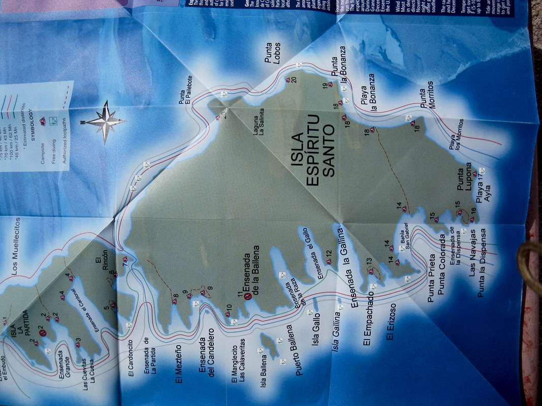
Here's a picture of the map in the guide here:
Digital:
Update: It looks like http://www.peakfinder.org has some detailed topo data for IES. Using the drop down option next to the location input box (viewpoint> Maps), Peakfinder puts the summit at:
24°29'49'N 110°20'37'W
You may be able to get better detail with the GoTrekkers digital maps
GoTrekkers Baja Mexico digital topographic maps
http://www.gotrekkers.com/mm5/merchant. ... y_Code=140
Also, I gave a cursory glance for Baja maps here, but didn't see anything:
http://www.lib.utexas.edu/maps/jog/latin_america/
Don't forget Google Earth for the satellite imagery.
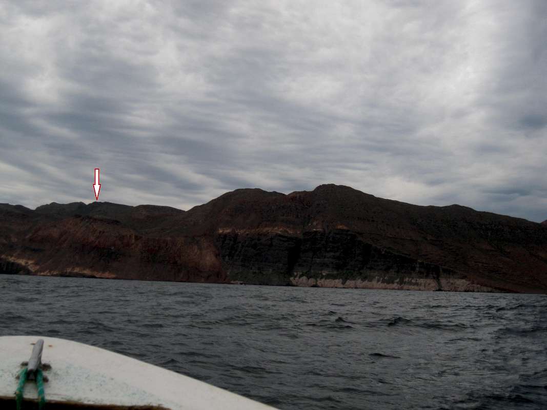
FWIW, here's my best guess at where the summit is located (image taken from the Northeast side of IES):
Finally, if you have a go at the summit, please post your experience/new information here on Summitpost.
Chilaquiles. Hmmm....
As no one answered my original post, I thought I'd update it with some information that I obtained. Unfortunately due to time constraints I wasn't able to attempt the Isla Espiritu Santo (IES) highpoint, but I am posting the info here in case some kayaking aventurero/a needs to feed the inner mountaineer whilst water-bound around the Isla.
I spoke with a local kayak guide about the IES summit and she said that the rock quality is poor and that you need "need a rope" for the last section of the summit. FWIW, it sounded like she hadn't been to the top and needing a rope really could mean anything from easy class 3 (but possibly intimidating for the non-climber) to an actual, short technical pitch. From the view I saw from the east side of the Isla, it didn't look like there was much of a summit block. Google Earth didn't show much of a summit block either from what I could tell. It's possible she was trying to discourage me from doing any x-country travel on the island. Who knows?...Hell, one more good reason to strive, to seek, to find and not to yield.
There seems to be two starting points to climbing the highpoint. Both places have beautiful camping beaches.
1. The Point between Isla Partida and Isla Espirtu Santo, aka Playa Partida. Here's a description of this area care of Baja Outdoor Activites IES boating/kayaking map: "There are two sand bars in the channel between channel between Isla Partida and Isla Espirtu Santo. On the northeast bar, up against the cliff, there is good camping. The huge crater walls that surround this area and the vast expanse of shallow water provide a spectacular view, and one can easily imagine how Partida and Espiritu Santo were one land mass before this volcanic crater was breached by the sea. It is possible to paddle though the channel to the east side of the island even at low tide."
Note if you go this route, you will have to climb over the first ridge and likely down into a gulley/wash/canyon before accessing the next ridge to get up on the massif proper. I'm guessing this might take at least 3-4 hours one way from a Playa Partida camp. Note, there are two small fishing camps at Playa Partida, one on the Partida side and one on the Espiritu Santo side. There is also a park ranger "shack" on the IES side, if you are interested in the Juanito Law presence. Word on the beach was that the park rangers did not use the park hut very often.
2. Candelero. Here's a description of this area care of BOA once again: "Two stunning beaches with a spectacular ridge that splits the bay in half. It is easily identified by the small islands in the bay that make great areas for snorkeling. A 10 minute hike behind the northern leads to a well were you can rinse with 'fresh' water and a further 10 minute hike and you arrive at a dry waterfall, wild fig trees and spectacular over-hanging rocks." The BOA IES kayaking map shows two west-to-east trails from Candelero. One trail starts on the north side of the beach and one starts on the south side. Both trails join a little under half way across the island. FWIW, it looks like the south trail gets you closest to the highpoint. Obviously you will be doing some off-trail hiking when the trail runs out.
Is off-trail hiking allowed on Isla Espiritu Santo?
Here is the official webpage for Parque Nacional Archipiélago de Espíritu Santo
http://pnaes.conanp.gob.mx/
"caminando a través de los senderos autorizados"
walking across the authorized paths
Also:
COMISIÓN NACIONAL DE ÁREAS NATURALES PROTEGIDAS, MÉXICO (CONANP)
http://islasgc.conanp.gob.mx/BCS/PNAES/PNAES.htm
"No hagas nuevas veredas, utiliza sólo las autorizadas (ver mapa)."
Do not make new paths, use only the authorized
Based on the two translations from the two webpages above, it would seem that CONANP at least discourages off-trail hiking. Interpret what "new paths" means to you. If in doubt, ask a park official. FWIW, on the upper portions of the climb, you are probably going to be hiking a lot on boulders with minimal impact. Just a thought.
Maps for IES (paper vs. digital)
Paper:
After doing a bit of searching the best paper map I could come up with for IES was the Baja Outdoor Activites Isla Espiritu Santo kayaking and camping map. The map is not topographic and not very detailed but shows the main bays and beaches. The back side of the map has a very useful beach camping guide. You can probably get a copy (free or fee?) if you stop in the BOA building on the north side of the Malecon in La Paz, B.C.S, Mexico.
http://www.kayactivities.com/
Here's a picture of the BOA map mentioned above:
Page 21 of the Baja California Almanac shows some topo data for IES, but the scale is really too small to be of any use. The BOA map mentioned above is better. As a side note, the Baja California Almanac is a GREAT Baja travel/planning resource (especially if you are doing the paddle run from Loreto to La Paz (recommended)). Unfortunately, the Almanac is currently out of print. WTF? Did the publishers go bankrupt?
http://www.baja-almanac.com/
Also note that another good map and camping guide for IES was produced by CONANP but as of this writing is out of print:
Camping Guide Complejo Insular Espiritu Santo
The guide is in both Spanish and English and has good information on the beach campsites on Isla Partida and IES.
Here's the contact information for CONANP in La Paz if you would like to inquire if the guide is back in print:
Área de Protección de Flora y Fauna
Islas del Golfo de California
5 de Mayo #1035 Interior 1.
Entre Lic. Primo de Verdad y Marcelo Rubio
C.P. 23000 La Paz, B.C.S.
Tel/Fax (612)-128-41-70
lapaz(AT)conanp.gob.mx
Here's a picture of the map in the guide here:
Digital:
Update: It looks like http://www.peakfinder.org has some detailed topo data for IES. Using the drop down option next to the location input box (viewpoint> Maps), Peakfinder puts the summit at:
24°29'49'N 110°20'37'W
You may be able to get better detail with the GoTrekkers digital maps
GoTrekkers Baja Mexico digital topographic maps
http://www.gotrekkers.com/mm5/merchant. ... y_Code=140
Also, I gave a cursory glance for Baja maps here, but didn't see anything:
http://www.lib.utexas.edu/maps/jog/latin_america/
Don't forget Google Earth for the satellite imagery.
FWIW, here's my best guess at where the summit is located (image taken from the Northeast side of IES):
Finally, if you have a go at the summit, please post your experience/new information here on Summitpost.
Chilaquiles. Hmmm....
-

sendintheclowns - Posts: 1
- Joined: Tue Dec 01, 2015 2:03 am
- Thanked: 0 time in 0 post
Re: Isla Espíritu Santo's highpoint, accessible? (Baja)
I'm going here for a week over Christmas, definitely inspired thanks to all your info. I will let you know how it goes.
3 posts
Page 1 of 1
-
- Related topics
- Replies
- Views
- Last post
-
- The top of Baja
by bajaandy » Mon Apr 30, 2007 5:48 pm - 2 Replies
- 3758 Views
- Last post by madeintahoe

Sat May 05, 2007 12:42 am
- The top of Baja
-
- Canyoneering in Baja - Beta wanted
by Outdoorgirl_ca » Fri Mar 07, 2008 1:21 am - 1 Replies
- 3821 Views
- Last post by Hyadventure
Fri Mar 07, 2008 4:19 am
- Canyoneering in Baja - Beta wanted
-
- Topo maps of Baja - Mexico
by dennyboy » Thu Feb 10, 2011 7:51 pm - 7 Replies
- 20313 Views
- Last post by 7Tall
Wed Oct 19, 2016 12:26 am
- Topo maps of Baja - Mexico
-
- Baja California Almanac - availablity update
by Jesus Malverde » Thu Sep 09, 2021 7:10 pm - 1 Replies
- 5761 Views
- Last post by Maderita
Sun Oct 31, 2021 10:00 am
- Baja California Almanac - availablity update
-
- sierra de la laguna (baja california sur)
by MoabPeakBagger » Tue Nov 10, 2009 12:50 am - 0 Replies
- 3303 Views
- Last post by MoabPeakBagger
Tue Nov 10, 2009 12:50 am
- sierra de la laguna (baja california sur)
Who is online
Users browsing this forum: No registered users and 0 guests