Val Nardis is correct. The picture was taken close to Doss Del Sabion, in winter a highpoint of the small Pinzolo ski-area.
This was taken with my first digital camera in July 2001. The sharpness in distance is not so good.
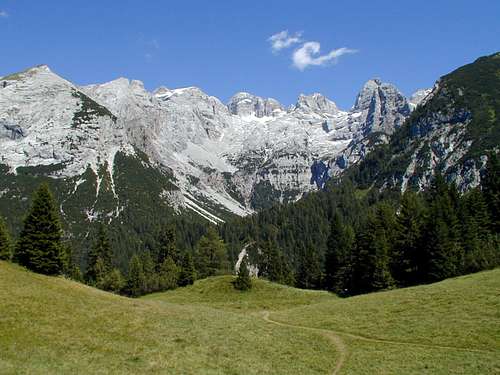
The highest mountain is snow-capped and peaking out left of the middle: it's Cima Tosa (3173m), once and before melting of it's summit glacier ice cap the highest mountain in the brenta group and still listed like this here on SP. Other sources say that now the highest is Cima Brenta, because even you can still find the 3173m in maps or guidebooks this elevation is nowadays about 50m to high. Most pictures of Cima Tosa are from the north (ice-coloir) or from southwest (normal route).
The peak inside the middle of the picture with the snowfield at the base of the rock is Cima d'Ambiez (3102m).
Compare this picture:
http://www.summitpost.org/view_object.p ... _id=113874
Cima Nardis (2623m) is the second peak from the left side (next to the first peak in front with some grass on top).
Cima Francinglo II (2880m) is the third peak from the left side. Cima Tosa is peaking out above it and between it and Cima d'Ambiez (which is hard to see because of the old digital prozessor of that time).
The fifth peak from left to right is Cima di Val d' Agola (2960m), the sixth peak from the left side (or the first from the right side) is Prato Fiorito (2900m).
Ok, it's solved so I am waiting for the next one and want to guess!