Page 1 of 1

Advice on Mt Tom

PostPosted: Wed Jul 31, 2013 2:18 am
by Ambret
A friend and I plan to hike Mt Tom in mid August. After following the old jeep trail up from Horton Lake and reaching the southwest ridge of Mt Tom, it appears there are two routes to the summit: (1) follow the old road to the abandoned tungsten mine, and then head up to the top or (2) follow the southwest ridge to the summit. We'd appreciate any advice on the advantages/disadvantages of these alternatives.

Re: Advice on Mt Tom

PostPosted: Wed Jul 31, 2013 2:54 am
by boyblue
It was many years ago, but I ascended the SW ridge and descended the steep chute to the mine. There's some class 3 scrambling along the upper part of the ridge that made it a much more enjoyable ascent route than all that loose scree in the chute above the mine. The chute IMO is a nice descent route.

Here's a photo of Mount Tom I took during that trip from Peak 12200+ to the west. Both routes are easily visible.
Image

Hope this helped. :)

Edit: A few more pics of the SW Ridge:

This looks up from near the beginning of the class 3 sections:
UpperTom.jpg
Note: I think nearly all the steepest portions can be bypassed by staying on the left (NW) side of the ridge. In fact, I recall following a climbers use trail in several spots.
UpperTom.jpg (706.11 KiB) Viewed 2302 times

A view looking down at the same section of ridge from the summit:
Tom3.jpg
Not much exposure- just a bit of scrambling mixed with class 2, as I remember.
Tom3.jpg (731.86 KiB) Viewed 2302 times

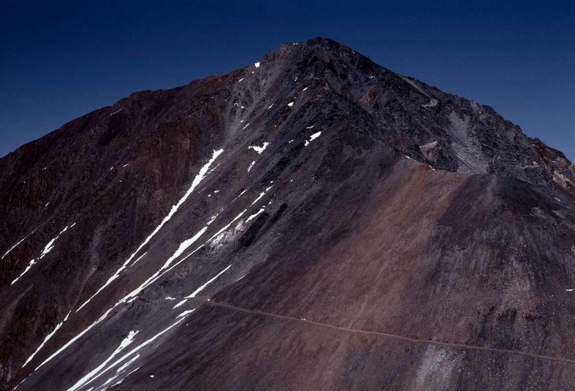
This view looks up from along the road to the mine. The summit is in the center; the upper SW ridge is along the right skyline.
TomFrmBelow.jpg
This picture seems to confirm that there wasn't much exposure along this side of the SW ridge.
TomFrmBelow.jpg (845.74 KiB) Viewed 2302 times

Re: Advice on Mt Tom

PostPosted: Wed Jul 31, 2013 2:58 am
by mrchad9
^^^^
What he said.

Re: Advice on Mt Tom

PostPosted: Wed Jul 31, 2013 5:51 pm
by calipidder
I wrote up my experience using the steep chute (there are actually a couple - you cross into different ones) here (did it last september). As mentioned above, the upper ridge has some really nice scrambling that was incredibly welcome after the loose crap in the chutes. It was not a pleasant climb. I was just coming back from a broken foot so was extra cautious, but I wouldn't do it again.

Re: Advice on Mt Tom

PostPosted: Thu Aug 01, 2013 2:52 am
by Ambret
Thanks all for the helpful advice and calipidder for the trip report.

Re: Advice on Mt Tom

PostPosted: Fri Aug 23, 2013 6:42 am
by Ambret
Just to close the loop, I summitted Mt Tom on August 19. After crossing out of Horton Lake Valley, I took the road toward the tungsten mine for about one-third mile and then ascended to the southwest ridge and followed the ridge toward the summit. After a couple of false summits, I found the true top, marked by a tall rock cairn. Given deteriorating weather, I descended via the loose scree trails directly to the tungsten mine.

Although I strayed a bit from the ridge (was probably about 600 vertical feet below the summit when I figured it was time to turn up), the talus and boulder-hopping on this route made for a much more enjoyable hike than my aborted attempt in 2012 directly up the scree trails from the tungsten mine.

Thanks again for the very helpful advice, particularly to boyblue and the additional pictures.

Re: Advice on Mt Tom

PostPosted: Fri Aug 23, 2013 3:19 pm
by boyblue
Ambret wrote:Just to close the loop, I summitted Mt Tom on August 19. After crossing out of Horton Lake Valley, I took the road toward the tungsten mine for about one-third mile and then ascended to the southwest ridge and followed the ridge toward the summit. After a couple of false summits, I found the true top, marked by a tall rock cairn. Given deteriorating weather, I descended via the loose scree trails directly to the tungsten mine.

Although I strayed a bit from the ridge (was probably about 600 vertical feet below the summit when I figured it was time to turn up), the talus and boulder-hopping on this route made for a much more enjoyable hike than my aborted attempt in 2012 directly up the scree trails from the tungsten mine.

Thanks again for the very helpful advice, particularly to boyblue and the additional pictures.


I'm glad you had a successful adventure. :D