Page 5 of 6

Posted:
Sat Jun 26, 2010 1:29 amby The Chief
Doors of Perception will be completed along with some other rarely done lines in the middle of July...Oh Yeah!
Posted:
Tue Jun 29, 2010 3:44 pmby rhyang
How are things looking at Gayley Camp ? Any dry bivy sites yet ?
Planning to be in the area next week to check out the Swiss Arete or Starlight Buttress or something like that.
Posted:
Tue Jun 29, 2010 4:28 pmby PellucidWombat
hamik wrote:V Notch shrund has nice snow bridge (same as from summer 09) on the left side. U Notch has one on the right. Clyde and N couloir Thunderbolt looked harder to access, but I didn't look carefully; in any case there is easy access via rock for those two.
http://picasaweb.google.com/lh/photo/K0 ... directlink
The 'schrund on the N Couloir of Thunderbolt was barely beginning to show as of June 20. The trail was snow free until the stream crossing heading up the final bit to Sam Mack Meadows. Half of the meadows had melted out.
There might be a few limited areas melted out near Gayley camp. When we went up on the 20th, we found a small area of rocks melted out on the crest of the right lateral moraine of the Palisade Glacier.
Posted:
Tue Jun 29, 2010 5:45 pmby tb00957
Rob,
Rick and I were at Gayley camp Jun 20-22. Nobody else camped there. Lots of bivy spots, all dry. We found a trickle, good in the afternoon. Bring water containers since I'm not sure you can get it in the morning. Water bottle got ice overnight, but not too cold.
Linda
Posted:
Tue Jun 29, 2010 7:46 pmby rhyang
Excellent ! Thanks Linda, and say hello to His Boothness for me

Posted:
Tue Jul 06, 2010 11:47 pmby Hyadventure
As of July 5 there is no snow on the NF of Big Pine Creek trail. The Glacier Trail to Sam Mack Meadow had patchy snow, but not enough to require the use of crampons. The trail from Sam Mack to the moraine (Gayley Camp) was easily followed to the ridgeline. After the trail moves to the far side of the ridgeline heavier show covered some sections of trail where we needed to scramble to the top of the ridge to bypass. We climbed the snowfield to the top of the moraine so I can’t comment on the condition of the slabs leading to Gayley Camp.
The bergschrund in the Clyde couloir was wide opened. We were able to successfully climb rock on the left side to bypass. The U-Notch bergschrund still has a small bridge, but we only saw it from the distance.
We descended the snowfields (between 9 and 10 am) to return to Sam Mack with minimal postholing.
I made the same trip July 4 weekend of last year. I was surprised that in comparison to last year, trail conditions were only slightly worse.
Posted:
Wed Jul 07, 2010 1:28 amby JJBrunner
Anyone know if any ice is showing in the U or V notches and cylde couloir?
Posted:
Wed Jul 07, 2010 3:02 amby lefty
from my observation with Hyadventure this past weekend, there is a small amount of ice starting to show in the Clyde Couloir but there is also a lot of ice falling on the route from the walls of North Pal on the left side of the couloir.
Posted:
Wed Jul 07, 2010 4:37 amby Hyadventure
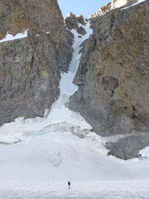
Clyde

Posted:
Wed Jul 07, 2010 5:28 amby WML
...AWESOME!!!!!!!!
Posted:
Wed Jul 07, 2010 5:45 amby JJBrunner
Sweet, I'll have to give that a shot soon
Posted:
Wed Jul 07, 2010 5:46 amby Hyadventure
U-Notch

Posted:
Thu Jul 22, 2010 6:26 amby PellucidWombat
As of July 17 . . .

U-Notch

V-Notch
and the mosquitoes are out in force!
Posted:
Thu Jul 22, 2010 8:08 amby hamik
Yikes! Compare to last year in late September:
Note the absence of, uh, a giant rockfall scar.
Posted:
Wed Sep 01, 2010 7:45 amby hamik
Anyone have recent pictures of V Notch (and maybe anecdotes about rockfall frequency)?