Page 1 of 1
Corte Madera

Posted:
Tue Dec 28, 2010 7:44 pmby Deb
Looking for info on camping and climbing at Corte Madera. The ACSD guide book sure tells you how to get there and has beautiful color pics, but I can find no info on whether you can rambo camp at the trailhead or somewhere nearby.
What's the scoop?
Re: Corte Madera
Posted:
Wed Dec 29, 2010 4:17 amby ScottyP
For when ??
Re: Corte Madera
Posted:
Wed Dec 29, 2010 3:39 pmby Deb
Was hoping to go for New Year's, but the weather is looking to be a bit too cold for that area. Would like to check it out in Feb or March....or whenever the temps are above 45 degrees.
Re: Corte Madera
Posted:
Wed Dec 29, 2010 7:51 pmby Denjem
It is Cleveland National Forest. I don't think you can camp there though. Just going with the track record of SD county.
Re: Corte Madera
Posted:
Wed Dec 29, 2010 11:55 pmby Bob Burd
It's a pretty short hike from Corral Canyon Rd to the east, about three miles along the Espinosa Trail that runs along the south side of Corte Madera. The summit is near the Corral Canyon OHV area and camping is available in several undeveloped sites, as well as other campgrounds at nearby Lake Morena and Boulder Oaks. I was just there a few days ago but it was fog-shrouded at the summit. The summit block is class 5.IwishIhadarope. Looks like there is some good cliffs/climbing on the south side, but the clouds covered it while I was there. Here's a
map of the area taken from the OHV kiosk at Four Corners.
Re: Corte Madera
Posted:
Mon Jan 03, 2011 9:50 amby Deb
Thanks Bob. We ended up hitting a couple of peaks in the Turtle Mtns (Kettle BM and Negro Peak) becuz that's the warmest place I could find this weekend. We'll get to Corte Madera this Spring.
Re: Corte Madera
Posted:
Wed Jan 05, 2011 2:02 amby tradmonkey
Camping at the Corte Madera trailhead is totally cool. Just stop in the Alpine ranger station on the way out to get a permit. No wood fires are allowed.
Re: Corte Madera
Posted:
Thu Jan 20, 2011 5:03 amby HeyItsBen
Deb, I think it depends on what you call the trailhead. Most people seem to park on Corral Canyon/Morena Stokes Valley Rd and hike in from there, its a pretty small dirt turnout, and I don't think you can or would want to rambo camp there. Lots of rangers cruising around also due to the OHV area...
If you drive up and over Los Pinos to the saddle between Los Pinos and Corte Madera, I think you could get away with it no problem. A much larger parking area, tucked into trees/bushes. This parking area is 0.3 miles driving distance north from the true saddle between the two peaks. The road up Los Pinos is paved, and if I remember correctly from there its 2.0 miles on a dirt road to reach the area I'm talking about. The road is in pretty good shape, 2WD with moderate clearance can make it no prob.
The wall is very impressive!! I'd love to see some pics once you guys get out there.
I can email you a map if it would help you out with finding the parking area, or a large (4.2MB) shot of the wall, you can zoom in and see the climbing routes. PM me if interested.
Ben
Re: Corte Madera
Posted:
Fri Jan 21, 2011 4:19 amby Say yes to crack
There are seasonal closures at CM for raptor nesting. In the past it has been from Jan. 1 to Jul. 1
It usually affects only parts of the cliff.
Check with,
Accessfund or
http://www.alliedclimbers.org/access.php or
Cleveland NF
Re: Corte Madera
Posted:
Fri Jan 21, 2011 6:03 amby Deb
benjamingray wrote:Deb, I think it depends on what you call the trailhead. Most people seem to park on Corral Canyon/Morena Stokes Valley Rd and hike in from there, its a pretty small dirt turnout, and I don't think you can or would want to rambo camp there. Lots of rangers cruising around also due to the OHV area...
If you drive up and over Los Pinos to the saddle between Los Pinos and Corte Madera, I think you could get away with it no problem. A much larger parking area, tucked into trees/bushes. This parking area is 0.3 miles driving distance north from the true saddle between the two peaks. The road up Los Pinos is paved, and if I remember correctly from there its 2.0 miles on a dirt road to reach the area I'm talking about. The road is in pretty good shape, 2WD with moderate clearance can make it no prob.
The wall is very impressive!! I'd love to see some pics once you guys get out there.
I can email you a map if it would help you out with finding the parking area, or a large (4.2MB) shot of the wall, you can zoom in and see the climbing routes. PM me if interested.
Ben
Oh this gets confusing.....yes, please email me a map; maybe I can decipher it. Currently, I am unable to climb....or much of anything else right now...but I think we'll really be interested in checking this place out in March. Thanks!
Re: Corte Madera
Posted:
Tue Jan 25, 2011 4:37 amby HeyItsBen
Tried to email with no luck, but this map should help. Green is paved, red is dirt. "Park1" is where most people park, no way you can rambo camp there. "Park2" should be no problem.
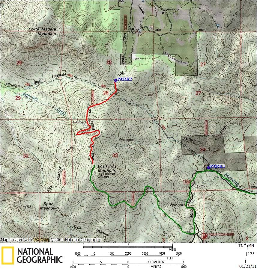
From the 8, go 3.3 mi south on Buckman Springs Rd, then make a right onto Corral Canyon (the highlighted green route on the map). Corral canyon is dirt at first but it turns into pavement quickly. Pass the first parking area "park1" at the 90 degree bend, and turn right when you get to 4 Corners (signed). From here its one lane with plenty of turnouts. Once near the top of Los Pinos, you'll see an obvious dirt road heading towards Corte Madera, take this for 2 miles. There are other dirt roads that intersect it but just stay on the main one. Go .3mi past the junction/saddle to the parking area "park2". You'll see a trailhead for the hikers trail with a sign talking about the birds in the area. Keep in mind that the road continues north into private ranches. Hope this helps...