Page 1 of 1
Great Western Divide/High Sierra Trail Questions..

Posted:
Tue Apr 22, 2014 6:26 amby MCGusto
Hey all,
So about two months ago when the Sierra was looking at record LOW snowpack, I was considering an early go at the High Sierra Trail at the end of May. Since then, though, it seems Mother Nature has caught up with our friendly Range of Light and dumped a significant amount of the white stuff. So now I'm seriously considering abbreviating my plans and looking to possibly just head out as far as I can go, hopefully at least to the Great Western Divide up to Hamilton Lake or so, and was wondering if anyone has been out that far as of recent.
Any beta on the backcountry conditions heading out of Crescent Meadow would be super helpful, and pardon me in advance as I will probably repost as my permit date gets closer to try and best judge conditions.
Thanks,
Gusto
Re: Great Western Divide/High Sierra Trail Questions..
Posted:
Wed Apr 23, 2014 8:16 pmby Bascuela
One might encounter the most snow along the trail around the Kaweah gap area. The divide (west side) takes the "brunt" of the snow. With that being said, the switchbacks near Whitney will have some snow at the end of May.
- Aaron
Re: Great Western Divide/High Sierra Trail Questions..
Posted:
Wed Apr 23, 2014 9:04 pmby asmrz
My wife Penelope and I hiked the High Sierra Trail variation last year starting June 10. 2013 was very similar to this year in terms of snow on the West side of the Sierra.
We had absolutely no snow all the way to Colby Pass. We didn't go to Whitney, we looped back to Lodgepole (about 94 miles). All we saw were fields of flowers, ferns and lush green grass everywhere. Fantastic climbing scenery, in fact the HST rivals JMT, easily. Very few people on the trail.
I would say mid to late May and up, you are fine to go even if you go to Whitney via Guitar Lake. There might be some snow the last few miles, but nothing major IMO.
Re: Great Western Divide/High Sierra Trail Questions..
Posted:
Thu Apr 24, 2014 3:18 amby sharperblue
Exactly the wrong time of year to make the call on that trail; I ran up to the Divide via HST/Crescent Meadow in late January and encountered zero snow until Hamilton Lakes (actually, a bit at the trailhead itself as well) - a friend was on it two weeks ago and reported excellent conditions, but your best bet is to call the station there and ask. A pure guess is that it would go fine to Hamilton Lakes still without much cursing and postholing
Re: Great Western Divide/High Sierra Trail Questions..
Posted:
Sun Apr 27, 2014 5:17 amby MCGusto
Thanks guys,
I'm going to actually try and get up there mid-May to assess stuff first hand. "Worst-case" scenario is I'd have to do an out-and-back trip, but was mostly concerned with the car shuttle.
Would be kinda sucky to set up the carpool....then not be able to make it across one of the passes!
If anyone heads up there, lemme know!
Gusto
Re: Great Western Divide/High Sierra Trail Questions..
Posted:
Sun Apr 27, 2014 5:20 pmby asmrz
MCGusto
I copied this from the High Sierra Trail page here on SP. You don't need to worry about the car shuttle if you don't mind avoiding Whitney.
"My wife Penelope and I just finished the hike avoiding Whitney and looping back to Lodgepole. It was about 92-95 miles and took us 9 days. We each carried a bear canister, but every major campsite/s on the hike has at least one bear box. That is either blessing or a curse, depending on how much you value your solitude in the mountains.
We decided to go over Colby Pass once we got to Junction Meadow. The trail offers continuing great alpine scenery.
Once over Colby Pass, we went down to Roaring River RS, then up over Silliman Pass to Lodgepole. The Sequoia Park bus system took us back to Crescent Meadow and our car (4-5 miles ?). Great loop and we avoided the Whitney mess!
The alpine climbing scenery on this trip is some of the best in the whole of High Sierra.
Moro Rock, Castle Rock Spire, the Fin, Angel Wings, Cherubin Dome, Eagle Scout Peak, Mt.Stewart, all those great looking peaks on the Western Divide, Whaleback and several small domes on the other side...WOW, so much granite everywhere, we wished we were 20 years younger.
We hiked the HST in June 2013, there was little snow, huge amount of ferns and flowers and very few people.
The scenery on this trail is as good (if not better) than JMT, without the people... Thanks for inspiring us with the HST page."
Re: Great Western Divide/High Sierra Trail Questions..
Posted:
Wed May 28, 2014 6:52 amby MCGusto
Just updating this, as some might find it useful.
Went out of Crescent Meadow up as far as Precipice Lake (above Hamilton and below Kaweah Gap). Snow free the whole way, with the exception of maybe two to three 20 foot sections right below Precipice Lake. Hamilton is ice free and lakes/rivers below are ice free. Precipice is still frozen.
Talked with a guy who went up to Kaweah Gap and he said many of the higher lakes near the pass were still frozen. Also ran into two other guys crossing over the gap on my way down with fishing poles who said they might head over towards Sawtooth Pass and would report on conditions.
Also, currently there is no water at Bearpaw Meadow as the "camp" isn't open yet. Most people (like myself) were opting to spend the night back a mile at Buck Creek. Beautiful conditions out there with 70's during the day and (maybe?) mid 40's at night.
Bears are out and active, and one guy in the parking lot said he was trail running, spooked a bear which ran up a tree, then the bear got down the tree and started coming at him! And this was while I was in the parking lot getting ready to set out!
He also said the trail to Alta Peak was still covered in snow.
I'll be heading out that way again this weekend and will report back with conditions in other areas, depending on where I'll go.
Hope everyone had a great Memorial Day weekend!
Re: Great Western Divide/High Sierra Trail Questions..
Posted:
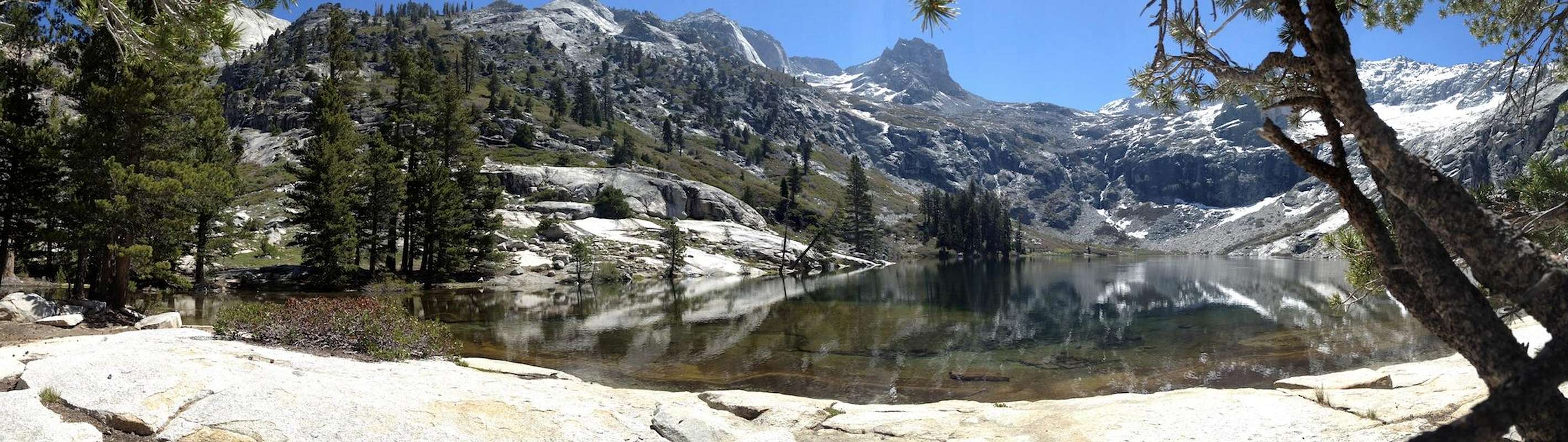
Wed May 28, 2014 3:01 pmby KathyW
Not a super clear photo, but here's a view over to the Kaweahs and the Kern River trench taken from Kern Peak on 5/25 - pretty dry looking:

Re: Great Western Divide/High Sierra Trail Questions..
Posted:
Wed Jan 28, 2015 7:31 amby HBS
Hi there, joined Sierra Post.org because of this topic (HST). My plan is to do an out-and-back hike/camp on HST starting Crescent Meadow and turning back at Precipe Lake (a few miles after Hamilton Lake). My main reason is I only have 4 days I can afford to take.
What is the weather like in June? Seems like it is okay meaning no snow til Gaweah Gap which I would not cover in this 4 day out and back trip. Anyone know what weather I should expect in June? Also, any comment about the mosquitoes?
Re: Great Western Divide/High Sierra Trail Questions..
Posted:
Tue Feb 03, 2015 5:06 pmby mrchad9
Weather should be fine in June HBS, and I wouldn't expect snow below the lake. The entire approach is south facing and doesn't hold much snowpack.
Re: Great Western Divide/High Sierra Trail Questions..
Posted:
Wed Apr 15, 2015 10:32 pmby Sachin_Sawant
Hi,
I am planing to thru-hike HST in mid May 2015 (start date 5/14). I am not able to find what are the latest snow/trail conditions on HST. Would the trail be passable after Kaweah Gap?
This is what SEKI website has - "As of 3/27, Trail is clear of snow most of the way to Bearpaw Meadow
Bearpaw to Hamilton Lake will have mushy snow turning to ice. Kaweah Gap not passable."
I called wilderness office but I couldn't manage to get past the recorded message.
Thank you.
Re: Great Western Divide/High Sierra Trail Questions..
Posted:
Thu Jun 18, 2015 6:49 pmby Elise
Hi All,
We are going to do HST starting June 21st. Anyone hear of the trail conditions? What is Kaweah Gap like?
Sachin_Sawant, I was also not able to get any up to date info from the wilderness office. How was it for you?
Elise
Re: Great Western Divide/High Sierra Trail Questions..
Posted:
Sun Jun 28, 2015 3:58 pmby MCGusto
Don't be surprised by the ranger stations not knowing conditions this early in the season. The rangers told me last year MOST of their personnel are dedicated to front-country stuff during the beginning, busier part of the season. Your best bet is that someone who has gone out there posts in. In my experience last year, the ranger station was relying on hikers reporting back to them as to conditions on the trail, which didn't happen all that often because most of the time people are picking up permits, hiking, then bailing out of the park.

Good luck on the HST! I'll be out there again in August….
Gusto
Re: Great Western Divide/High Sierra Trail Questions..
Posted:
Sun Jun 28, 2015 7:19 pmby Bob Burd
I'd be surprised if there was any snow of consequence on the HST. I just came back from Horseshoe Meadows/Cottonwood Lakes area and there was almost no snow anywhere. Here's a (crappy) view from Mt. Anna Mills (12,000ft) looking west to Kaweah and the Big Arroyo:

There's just no snow to be seen. And Kaweah gap is almost 1,500ft lower than bone-dry Anna Mills.
Re: Great Western Divide/High Sierra Trail Questions..
Posted:
Fri Jul 10, 2015 4:39 amby rockcarl
If anyone is still interested in trail conditions, I just finished a 6 day thru-hike on July 2. No Whitney summit because of lightning and generally crappy weather

. But the only snow I saw on the entire trip was a small patch above 13k feet on a Mt. Kaweah side-trip.
My
trip report has some more info about the weather.