I was relying on the opinion of this dog (click below):
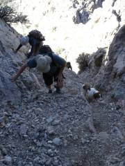
She didn't like going back down the chute.
Jokes aside, the NW chute is a shooting gallery when there are a few people in it at once. Nothing scares me more than loose rock.
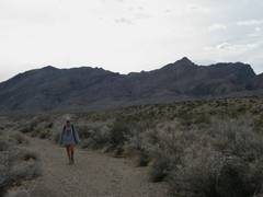
This shows the south route. I don't remember much loose rock, but it was nearly 7 years ago. The canyon was impressive.
However, the south approach to Muddy is blocked about 1.65 south of the old parking lot, at ~2350' elevation. I walked up to the previous parking. The BLM is taking this seriously; I saw no tire tracks past the block, and the old road has faded into nothing in a few places. They have clearly rolled rocks into the road in at least 5 places, forming barricades (kind of wimpy for real jeeps, but enough to keep me out). In a few places, natural gully washers have placed some nasty rocks in the "road".
I've considered approaching Muddy from the E, via the Bitter Ridge Road:
I've been 10 miles up that road in the Subaru, but have to look farther. It's still a long haul. This is close to the "other" approach suggested by Hart in "Hiking the Great Basin" except I drive in from the south.
(The woman in the last photo is the mother of someone who has hiked with Kathy.)
