Page 67 of 110

Re: STATE HIGHPOINT CLIMBERS

PostPosted: Tue Oct 11, 2011 7:50 pm
by jdzaharia
By the way, Eagle Mountain was State HP number 2 for me.

Here might be a better shot of the glass-like water that morning:

Image

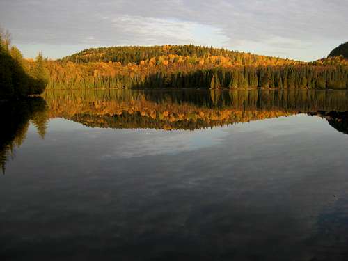
http://www.summitpost.org/eagle-mountai ... 9/c-151003

Member peaker559 posted this photo of Eagle Mountain back in July:

Image

I tried to get a photo of the peak from the west along the road to Brule Lake, but could not find a spot high enough to see it through the trees.

Re: STATE HIGHPOINT CLIMBERS

PostPosted: Fri Oct 14, 2011 9:07 pm
by Alpinist
Finally - we have a photo of Eagle Mtn. Well done to you both. Thanks for posting!

Re: STATE HIGHPOINT CLIMBERS

PostPosted: Sun Oct 16, 2011 10:18 pm
by Alpinist
Just finished the southern trifecta (AL, FL, MS) with my wife. It was a lot of driving but a very fun weekend. The weather was great and we had all 3 HPs to ourselves. We spent 1 night in Muscle Shoals and 1 night in Birmingham.

I dialed up Sweet Home Alabama on my iPhone while we were on the AL highpoint and realized that we unknowingly stayed in the only 2 AL cities mentioned in the song. (What are the odds?) :-)

Re: STATE HIGHPOINT CLIMBERS

PostPosted: Mon Oct 17, 2011 11:11 am
by Holsti97
Alpinist wrote:Just finished the southern trifecta (AL, FL, MS) with my wife. It was a lot of driving but a very fun weekend. The weather was great and we had all 3 HPs to ourselves. We spent 1 night in Muscle Shoals and 1 night in Birmingham.

I dialed up Sweet Home Alabama on my iPhone while we were on the AL highpoint and realized that we unknowingly stayed in the only 2 AL cities mentioned in the song. (What are the odds?) :-)


Congratulations on finishing the lower 48 George! How fitting that you will finish the 50 state highpoints on Mauna Kea in Hawaii. A great place to celebrate.

Re: STATE HIGHPOINT CLIMBERS

PostPosted: Mon Oct 17, 2011 7:56 pm
by Hotoven
Congratulations Alpinist! I'm glad your wife went with you and your done with them all but one!

Re: STATE HIGHPOINT CLIMBERS

PostPosted: Mon Oct 17, 2011 8:13 pm
by Bark Eater
Congratulations, George. I was pretty impressed with Cheaha. Wish I could have spent more time there. Hope to do a circuit of LA, MS, and FL (can't believe I haven't been to Britton Hill) in conjunction with a conference trip to New Orleans in the spring.

Re: STATE HIGHPOINT CLIMBERS

PostPosted: Tue Oct 18, 2011 1:39 pm
by Alpinist
Thanks guys. I was impressed with Cheaha too Frank. It was very scenic. Had I known how nice it was I would have stayed at the campground near the summit.

Re: STATE HIGHPOINT CLIMBERS

PostPosted: Sat Oct 22, 2011 10:16 pm
by Alpinist
HooBoy, that is a lot of driving. Sounds like a great trip though. Well done.

Re: STATE HIGHPOINT CLIMBERS

PostPosted: Sun Oct 23, 2011 3:18 am
by Holsti97
Bubba Fest?

Re: STATE HIGHPOINT CLIMBERS

PostPosted: Tue Oct 25, 2011 2:30 pm
by Alpinist
That depends on how aggressive you want to be and whether or not you want to see some of the local sights. I did it in 3 days. That didn't leave much time for sight seeing but I also didn't drive through the night.

Here's my intinerary on Google maps, with driving distances, etc.

http://g.co/maps/u5v54

Re: STATE HIGHPOINT CLIMBERS

PostPosted: Tue Oct 25, 2011 2:44 pm
by Jow
I think it also depends if your driving to the top or making hikes out of them; for example i did the 16mile round trip way to cling mans dome but instead you can drive to within 1/2mile of summit changes timing pretty drastically.
Below is my trip report however I put in some relaxing (drinking) time as well as hiking. http://www.summitpost.org/bourbon-beer-the-southern-six-pack/750465

Re: STATE HIGHPOINT CLIMBERS

PostPosted: Sat Oct 29, 2011 9:15 pm
by sm0421
hi guys, what would be a good map for hiking Kings Peak UT and Gannett Peak, WY? Thanks!

Re: STATE HIGHPOINT CLIMBERS

PostPosted: Mon Oct 31, 2011 2:32 pm
by Alpinist
sm0421 wrote:hi guys, what would be a good map for hiking Kings Peak UT and Gannett Peak, WY? Thanks!

Hiking Map & Guide, Northern Wind River Range (Earthwalk Press)

I didn't buy a map for Kings Peak. I just printed the topo map from SP for the standard route. Navigation is very straight forward. It's a trail hike all the way to Gunsight Pass. From there you have 2 choices; traverse the south side of Gunsight Peak to Anderson Pass (shorter but more of a scramble), or stay on the trail to Anderson Pass (longer and involves elevation loss). From Anderson Pass, you just follow the ridgeline to the summit of Kings Peak.

Re: STATE HIGHPOINT CLIMBERS

PostPosted: Tue Nov 01, 2011 3:10 pm
by Alpinist

Re: STATE HIGHPOINT CLIMBERS

PostPosted: Tue Nov 01, 2011 4:36 pm
by Bark Eater
Alpinist wrote:Our very own Hoslti97 received a little press a few days ago. Nice article Doug!

http://www.agriview.com/feature/urban-has-a-passion-for-highpointing-and-dairy/article_a434b554-00d5-11e1-89fb-001cc4c002e0.html


Good press! And now I understand "Holsti" :) I hope to have the lower 48 done one of these years myself!