Page 1 of 2
Can you help identify this location?

Posted:
Tue Jan 12, 2016 6:48 pmby Stuart_Online
Dear All,
A friend of my son's has a picture of an old family member from years ago. Unfortunately all the history has long since gone, but the family are left without a clue as to where in the world their forebear made it to.
All suggestions gratefully received...
Re: Can you help identify this location?
Posted:
Tue Jan 12, 2016 6:58 pmby ExcitableBoy
Big shot in the dark, but Eichorn Pinnacle?
Re: Can you help identify this location?
Posted:
Tue Jan 12, 2016 7:56 pmby Stuart_Online
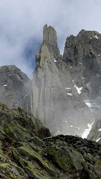
Thanks for being the first to have a go. But, as he is British in the 20s to 30s, I am guessing either Europe or what was the North West Frontier (Pakistan). That said, we have no real idea! The middle peak looks so unique?
Re: Can you help identify this location?
Posted:
Tue Jan 12, 2016 8:19 pmby sharperblue
looks a bit like Tahu Ratum (Karakoram) - you could futz around with Google earth and rotate the views on the nearby glaciers to see if you can get a match of the view to be sure
Re: Can you help identify this location?
Posted:
Wed Jan 13, 2016 1:04 amby sharperblue
definitely taken at a spot called Marpho Goro on the Biafo Glacier (just West of the famous Baltoro Glacier and K2) in northern Pakistan; PM Summitpost user Afzal and he could tell you exactly where for sure. Here's a link to one of his images:
http://www.summitpost.org/marpho-goro-rock-towers-karakoram-pakistan/390684/c-482248I'm sure i speak for many on here that we'd love to see more of those cool shots from the glory days as possible if you care to post them!
Re: Can you help identify this location?
Posted:
Thu Jan 14, 2016 1:49 amby dadndave
What's the bloke's name? If he was exploring the Karakoram in the early part of last century, there's probably some information about him and the expedition(s) that could be available.
Re: Can you help identify this location?
Posted:
Thu Jan 14, 2016 7:04 pmby sharperblue
That's a good point: there certainly weren't that many people exploring the Karakoram at that time; there may be quite a bit of material out there on the gentleman's adventure, including Oscar Eckenstein's (British) first attempt on K2 in 1902 - anyone of these chaps look familiar?

Re: Can you help identify this location?
Posted:
Fri Jan 15, 2016 6:10 amby Damien Gildea
"Definitely" ?

The peaks in the two photos are not the same, so not sure how you can be so definite. The pinnacle in the original photo resembles many formations in the Karakoram, some in the Indian Himalaya and some in the European Alps. The real indicator is the combination of the pinnacle and the big rocky thing in the back. It does look more like the Karakoram than anything else though. Tahu Ratum is not that slender.
If the family knows the guy's date of birth and how old they think he was in this photo, it could pin the date of it down to within 5-10 years, which would focus things a lot. Even in the 20th Century, the Karakoram and Indian Himalaya went years/decades without western exploration, so a date might help place it on a known expedition, and therefore location.
Re: Can you help identify this location?
Posted:
Fri Jan 15, 2016 6:37 amby sharperblue
Re: Can you help identify this location?
Posted:
Fri Jan 15, 2016 9:54 amby Damien Gildea
Hmmm, possible. Where is the third peak, partly visible in the new photo?
The middle peak - it's similar but upon looking closely, not the same. Which way would you move to make it the same?
Re: Can you help identify this location?
Posted:
Fri Jan 15, 2016 4:10 pmby MoapaPk
No real sense of scale. There are lots of lesser pinnacles/aiguilles in the Alps and other ranges.
Re: Can you help identify this location?
Posted:
Sat Jan 16, 2016 9:47 amby Gangolf Haub
MoapaPk wrote:No real sense of scale. There are lots of lesser pinnacles/aiguilles in the Alps and other ranges.
For instance
If you look at this picture, you could imagine the Karakoram as well

But no, not Los Galayos ..
Re: Can you help identify this location?
Posted:
Sat Jan 16, 2016 1:19 pmby Stuart_Online
Thanks for all the suggestions, but I don't think there is enough resolution in the photo to solve this one - or enough details on the man.
SYSOP - Feel free to delete this post as I cannot see a way to do so.
Re: Can you help identify this location?
Posted:
Sun Jan 17, 2016 12:55 amby Diego Sahagún
Stuart_Online wrote:Dear All,
A friend of my son's has a picture of an old family member from years ago. Unfortunately all the history has long since gone, but the family are left without a clue as to where in the world their forebear made it to.
All suggestions gratefully received...
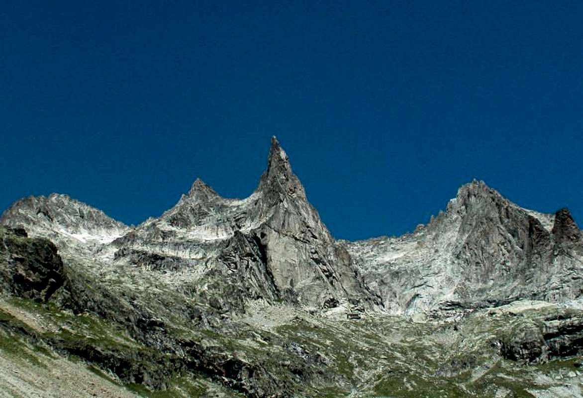
It seems to me Aiguille Dibona (3131 m) and Aiguille Ori. Soreiller (3380 m):
 http://www.summitpost.org/ecrins-aiguil ... ler/224023
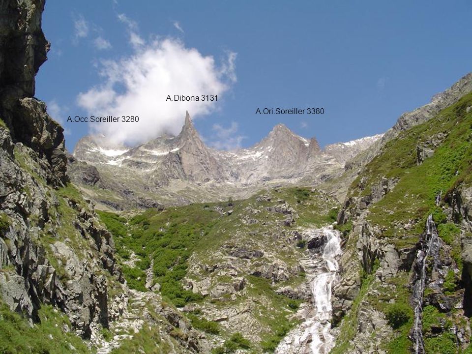 http://patitucciphoto.com/2013/08/16/cl ... rk-france/
Gangolf, it could be Torreón (Galayos) but I wouldn't recognise the peak to the right then
Re: Can you help identify this location?
Posted:
Sun Jan 17, 2016 6:27 pmby selinunte01
The pinnacle on the old photo looks VERY like A. Dibona and some rock features below (e.g. the slabs and ledges) are similar to those on the first pic of Diego.
But I wonder where this photo was taken exactly, if it is A. Dibona. In this case the man on the old photo must have stood on a height of about 2900 m and southwest of A. Dibona as the supposed A. Or. Soreiller is only then to be seen right of and behind the pinnacle. But I can not identify such a place on the map of the region. The only possibility to me is the ridge running south from Tete du Graou to Tete de la Marsare or south of the latter. But the huge cirque between these Tetes and the A. Dibona cannot be seen on the old photo.
And it seems to me that above the man there is another similar pinnacle half covered in clouds and there is no such thing if A. Dibona is viewed from this angle.
Another possibility is the man standing below Pointes de Burlan / A. Occ. de Soreiller and the mountain in the back is Tete du Rouget. The half covered second pinnacle could the be A. Centr. du Soreiller.
Any more ideas about that?