Page 2 of 2

Posted:
Thu May 20, 2010 1:18 amby Klenke
dskoon wrote:I was looking at this photo, which looked pretty similar. Different angle, etc. though.
That photo looks familiar.

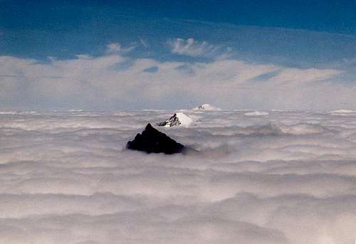
For the photo starting this thread...
the peaks in front of the Black Buttes are Pugh and White Chuck (black mass barely poking up through clouds).
The foreground peaks are those of the Bulls Tooth complex.
Posted:
Thu May 20, 2010 1:27 amby billisfree
If that is Sloan, then what mtns are those in the foreground?
It looks like Mt. Baker... but... the picture must have been taken from a mountain much closer to Mt. Baker.
I suspect the picture wasn't taken on Colchuck.
Posted:
Thu May 20, 2010 1:29 amby dskoon
[quote="Klenke"][quote="dskoon"]I was looking at this photo, which looked pretty similar. Different angle, etc. though.
That photo looks familiar.
Ahh, just saw that it was yours! Good shot! Have you climbed any of 'em?
Posted:
Thu May 20, 2010 4:59 amby billisfree
Yer right, I misquote! Glad you got a good laugh.

Posted:
Thu May 20, 2010 5:01 amby Klenke
dskoon wrote:I was looking at this photo, which looked pretty similar. Different angle, etc. though.
That photo looks familiar.
Ahh, just saw that it was yours! Good shot! Have you climbed any of 'em?
Nah, I haven't climbed any of 'em. I'm a desk monkey.
Posted:
Thu May 20, 2010 5:56 amby dskoon

Oh, my, that's a good one.
Posted:
Thu May 20, 2010 5:57 amby billisfree
LOL
Posted:
Thu May 20, 2010 6:56 amby mcpherma
Bill, I took the photo on my climb of Colchuck on 05/13/10.
Thanks for the info on the other peaks. I am suspecitng the cloud layer topped out around 6000 feet or so that day. It was clear for miles around us, so it was tough to judge altitude of the clouds being that we did not have to climb through them that day.
Posted:
Thu May 20, 2010 7:08 amby mcpherma
mvs wrote:mcpherma wrote:^^Yes! The corkscrew route. I just looked it up and the profile is a match. Thanks for the help. I need to learn my camera a little better. It seems most of my high altitude/ sunny day shots get washed out, but I do love the pic. If I could do it again, I would shoot just Sloan and have a little darker, crisper image.
An old tip that really helps me: meter your camera on snow, then frame the shot. If you meter on the brightest thing in the picture, you'll get richer colors and good balance.
I am going to have to try that. I am getting a little tired of the washed out look. Thanks.
Posted:
Thu May 20, 2010 8:37 amby billisfree
OK, I believe you mcpherma
as for dskoon's picture - what peak is that - between Sloan and Mt. Baker?
Posted:
Thu May 20, 2010 2:51 pmby dskoon
Bill,
No one ever said that the peak in the photo I posted was Sloan. I said it looked "similar," to the other photo.
The peak in the foreground of the one I posted is, in fact, Forbidden. For clarity sake, I did not take the shot, but here's an excerpt from the one who did:
Klenke:
Like Orion's belt stars, Forbidden Peak, Eldorado Peak, and Mt. Baker form a perfect line above the ubiquitous stratus on July 12, 1997. Though you wouldn't know it from this picture, there are many more craggy peaks down there. This photo taken from the summit of Mt. Buckner.