Wasatch Avalanche Conditions

Regional discussion and conditions reports for the great state of Utah, from the alpine peaks to the desert slots. Please post partners requests and trip plans here or in the Utah Climbing Partners section.
User Avatar
TyeDyeTwins

 
Posts: 208
Joined: Thu Apr 09, 2009 2:40 am
Thanked: 24 times in 17 posts

by TyeDyeTwins » Sun Mar 07, 2010 2:47 pm

Observation March 6 Went up Willow Fork yesturday. From the top of the fork we got a good view of a large 2-3 foot deep windslab in West Monitor. Strong windloading was occuring at the time in both South/West Monitor. With lots of new snow to transport I would expect the avalanche danger in these areas to increase. Skied Wills Hill and no instability was encountered.
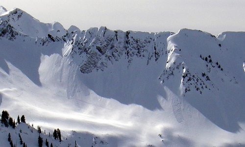
The 1st picture is of the large windslab in West Monitor.
Image

no avatar
marauders

 
Posts: 652
Joined: Wed Dec 08, 2004 1:25 am
Thanked: 13 times in 7 posts

by marauders » Sun Mar 07, 2010 3:32 pm

Toledo and Flagstaff March 6th. S and SE skied great. About 15" of snow with occasional deeper pockets. The skis would poke through to the underlying crust every now and then. No instabilities. The snow below 9K was getting heavy/cooked around 1pm. Above that it was pure gold.

Image

Image

Image

no avatar
Dan Shorb

 
Posts: 583
Joined: Thu Apr 08, 2004 2:06 pm
Thanked: 41 times in 29 posts

by Dan Shorb » Mon Mar 08, 2010 12:45 am

marauders wrote:
Image


Wow D E E P. looks fun, and you always capture it well.

We did God's Lawnmower and the adjacent eastern ridge 3x's today. By the end, the lower snow was heavy. Spring cycle soon? ... Not Yet I Hope.

User Avatar
TyeDyeTwins

 
Posts: 208
Joined: Thu Apr 09, 2009 2:40 am
Thanked: 24 times in 17 posts

by TyeDyeTwins » Mon Mar 08, 2010 5:35 am

Observation March 7 Started at Willow Fork and skied Wills Hill. Skinned up and out to Beartrap Fork where we got our second lap. Skied most of the way down Beartrap Fork and skinned up to Mill D North. From there we skied into the steeper side of Powder Park 3. Skied plenty of angles approaching 40+ all day with no incident. Of intrest, while skinning out of Willow Fork via North Willow we felt/heard 10 large whoomphs. It was just like being in the middle of a thunderstorm. These whoomphs were likely the result of windloading/crossloading on top of a patchy, but still present depth hoar layer. The whole day was a mix of Snow/Sunshine and there was still lots of blower powder to be had out there.
The 1st picture is of my group skinning up the ridge where we felt all the whoomphs.
Image
The 2nd picture is proof that conditions are still blower powder out there.
Image

User Avatar
TyeDyeTwins

 
Posts: 208
Joined: Thu Apr 09, 2009 2:40 am
Thanked: 24 times in 17 posts

by TyeDyeTwins » Tue Mar 09, 2010 9:10 pm

I was reading the UAC current conditions page this morning when I came up on an observers report about the avalanche in West Monitor. In the report they mentioned that the avalanche (from 2 days ago) was seriously over played by everyone who reported it. I was one of those folks who mentioned it in my post that night. In my defense all I have to say is that we were up there the day it released and it was not over played one bit (see our pic at the bottom of page 7). For an observer to investigate an avalanche after several days of strong winds and call everyone else who was there that day an outright lier is poor poor form to say the least.
Last edited by TyeDyeTwins on Wed Mar 10, 2010 5:06 pm, edited 1 time in total.

User Avatar
Blair

 
Posts: 810
Joined: Fri Jul 15, 2005 4:40 am
Thanked: 8 times in 8 posts

by Blair » Tue Mar 09, 2010 10:44 pm

Damn, some great face shots in those pics! SO JEALOUS!!!

Never peeked into this thread until now, cuz I live in CA, but this is a great one w bunches of great info. Good on all you posting up local conditions and showing off some fabulous BC skiing!!

We need a thread like this for California!

User Avatar
Ed F

 
Posts: 993
Joined: Sat Sep 07, 2002 8:15 pm
Thanked: 17 times in 14 posts

by Ed F » Tue Mar 09, 2010 11:23 pm

I was curious about this avalanche, so I went up in Summit Park to take a look. I had some trouble finding it even though I thought I was near their tracks, but I finally noticed it after we traversed an open area. The slide was pretty impressive for this area, and all of the info in the report matched with what I found.

Otherwise, the snow is still great in protected north-facing stuff. I hope this next storm comes in on the upper end of the models...could be another 15-20" if things go our way.

Image
Image

User Avatar
Ed F

 
Posts: 993
Joined: Sat Sep 07, 2002 8:15 pm
Thanked: 17 times in 14 posts

by Ed F » Wed Mar 10, 2010 12:02 am

TyeDyeTwins wrote:I was reading the UAC current conditions page this morning when I came up on an observers report about the avalanche in West Monitor. In the report they mentioned that the avalanche (from 2 days ago) was seriously over played by everyone who reported it. I was one of those folks who metioned it in my post that night. In my defense all I have to say is that we were up there the day it released and it was not over played one bit (see our pic at the bottom of page 7). For an observer to investigate an avalanche after several days of strong winds and call everyone else who was there that day an outright lier is poor poor form to say the least.


I know one of the other guys who reported that one. It wasn't over-reported.

User Avatar
TyeDyeTwins

 
Posts: 208
Joined: Thu Apr 09, 2009 2:40 am
Thanked: 24 times in 17 posts

by TyeDyeTwins » Thu Mar 11, 2010 4:55 pm

Observation March 10 Went from Willow Fork to Beartrap Fork yesturday. Storm totals were less than a quarter inch in both forks. No whooomphs, cracks or collapsing was felt/heard all day. Dug a snowpit on the North Willow Ridge (where we heard all the whoomphs the on sunday) and found 3 distinct sun crusts in the upper 2 feet of the snowpit. These crusts were most likely the main player in the whoomphing heard/felt on Sunday. Total snow depth on this steep east facing ridge was around 3-4 feet in depth. Ground facets have appeared to have gained a lot of strength making the full depth deep slab potential a thing of the past on this east facing ridge.

User Avatar
Ed F

 
Posts: 993
Joined: Sat Sep 07, 2002 8:15 pm
Thanked: 17 times in 14 posts

by Ed F » Fri Mar 12, 2010 1:12 am

Summit Park / Lambs today. Only thing worth talking about is that hoar formed last night up to about 8500 feet in sheltered, north-facing slopes. Anyone see hoar in the central part of the Wasatch?

Protected north still skied great today.

User Avatar
TyeDyeTwins

 
Posts: 208
Joined: Thu Apr 09, 2009 2:40 am
Thanked: 24 times in 17 posts

by TyeDyeTwins » Sat Mar 13, 2010 5:41 am

Observation March 12 Skied the Northern Powder Circut today (silver fork, to days fork, with a couple of laps in Cartiff Fork). Did lots of steep skiing with no incident. Around 10am in the morning we observed a small point release naturally occur at the top of North Davenport. Around noon the combo of winds and high clouds cooled things off from becoming too warm. The only real avalanche activity we saw were some point releases on the Lightning Bolt Apron and Holy Toleto. Also each steep northerly facing headwall had some new snow sluffing but nothing that would be too concerning. By 5pm things were cool enough to allow a decent of the southerly facing Emma Ridge. Dispite the warm temps earlier in the day there was little to no wet activity found in this area. There is still lots of BLOWER powder to be had out there.......and if the forecast holds true for tomorrow things are only gonna get deeper out there. Get your snorkel and flip flops ready.
The 1st picture is of the point release avalanches on the Lightning Bolt Apron
Image
The 2nd picture is proof that the powder is BLOWER out there. Couldn't resist sharing this one
Image

User Avatar
TyeDyeTwins

 
Posts: 208
Joined: Thu Apr 09, 2009 2:40 am
Thanked: 24 times in 17 posts

by TyeDyeTwins » Mon Mar 15, 2010 4:09 am

Observation March 14 Went to Silver Fork today. Performed a ski cut at the top of Over Easy (steep northeast facing chute) with no incident. Decided to charge like a mad man down the rest of the chute. According to my partners I made it through and then seconds later the entire chute avalanched. The slide consisted of new snow only but it ran quite fast. No good pictures were taken of it, for it was a fog fest at the time. Plans of multipul laps in this area were aborted and we decided (after digging several snowpits) to ski The Meadow Chutes. The colums we isolated took a very hard shoulder strike to get the new snow to fail. Conditions were so good in The Meadow Chutes that we skinned back up for seconds. Heard only one Whooomph today. It was on a northeast facing gully wall in Silver Fork and a burried facet layer could have been a factor. This whooomph is what we believe to be an outlier due to the location and does not reflect conditions in the rest of Silver Fork. This spot was a mid elevation, close to a creek, exposed to the elements spot which = a perfect breeding ground for surface hoar.
The 1st picture is of the snowpit we dug on The Meadow Chutes.
Image
The 2nd picture is of Troy skiing some DEEP powder in The Meadow Chutes.
Image

User Avatar
TyeDyeTwins

 
Posts: 208
Joined: Thu Apr 09, 2009 2:40 am
Thanked: 24 times in 17 posts

by TyeDyeTwins » Tue Mar 16, 2010 3:13 am

Observation March 15 Went up to Willow Fork and skied West Monitor today. The face was scraped by the wind but it was still a pleasent ski. The winds kicked back in during the afternoon preventing anything from getting too warm. Skied the steeper part of Wills Hill with no incident. What a beautiful day to get out there and play. Things are finally starting to get stable out there.
The 1st picture is of Troy skiing West Monitor.
Image

User Avatar
TyeDyeTwins

 
Posts: 208
Joined: Thu Apr 09, 2009 2:40 am
Thanked: 24 times in 17 posts

by TyeDyeTwins » Wed Mar 17, 2010 3:53 am

Observation March 16 Went up to peak 10,420 today. Skied a lap on the East face, the steep Northeast Chutes and one in the Northwest bowl. Lots of snowmobiles were in the area.....kinda reminded me of Mad Max: Return to the Thunderdome. By the end of the day the temps got so warm that even the treed Northwest bowl was turning to mush. Only saw some small wet avalanche activity off of Tri County Peak. The small point release avalanche reached the road but was not big enough to be that much of a concern. Saw a huge sundog today........good things to come? Things are ALMOST as stable as they get out there (excluding Millcreek and Lambs Canyon). Gonna have to do a big peak tomorrow. Maybe Red Baldy?
The 1st picture is of the small point release avalanche we saw off of Tri County Peak
Image
The 2nd picture is of Troy skiing one of 10,420's steep Northeast Chutes
Image

User Avatar
Ed F

 
Posts: 993
Joined: Sat Sep 07, 2002 8:15 pm
Thanked: 17 times in 14 posts

by Ed F » Wed Mar 17, 2010 10:35 pm

Sorry I haven't been on here in a bit -- life's been crazy. Skied NE off of 10420 (420 Trees). Snow was nice and soft down to about 9500 in shaded trees, but got really wet after that. Of course, there was plenty of wet snow action going on today. It was almost 50 degrees on top of 10420 without even a touch of wind. Hottest day of the year.

PreviousNext

Return to Utah


  • Related topics
    Replies
    Views
    Last post

Who is online

Users browsing this forum: No registered users and 0 guests