Introduction
![Pine Mountain Elevation Profile]() Elevation Profile
Elevation Profile![Mount Baldy, Dawson & Pine Hike]() GPS Overlay of Route
GPS Overlay of Route
Sunday, October 22, 2006
On a beautiful, southern California fall morning Tom and I headed up to
Mount San Antonio (Mount Baldy) starting in Baldy Village near the visitor center. It was 7:00 am and even though it is late October, it was already getting warm out. This is one of my favorite trails with great views, varying terrain and significantly different microclimate zones as you progress up the trail. You see yuccas growing next to a lush fields of ferns, fragrant
Bay Laurel trees, colorful poison oak, scrub oak, dense chaparral, incense cedars, Jeffery pines, lodgepole pines and stunted
limber pines near the summit.
Usually, the steep trail from Baldy Village to the summit of Mount Baldy is more than enough of a challenge, with close to 6000 ft gain over 6 miles it can be pretty brutal, especially in the heat of the summer. However today Tom and I were maybe feeling a little sadistic and have decided to follow the ridge north from Mount Baldy (10,064 ft) to
Dawson Peak (9,575 ft) and then even further to the summit of
Pine Mountain (9,648 ft). The traverse of the ridgeline from Mount Baldy to Pine Mountain required an additional 1300 ft elevation gain on the way to Pine Mountain and 1700 ft back up to Mount Baldy. The entire round trip was over 9000 ft elevation gain, over 1.7 vertical miles.
Baldy Village to Mount Baldy
The first stage of the hike to Mount Baldy took me approx. 3 hours 20 minutes. Slower than usual for me, I was not feeling very energetic, and my legs were weak. I was "sucking wind" as they say. I wasn't sure I even wanted to continue on to Dawson Peak then Pine Mountain. Anyway, Tom got way ahead of me, but I persevered and made it to Mount Baldy. After a break, I felt ready to tackle Dawson and figured I would see how I felt for Pine. Before hitting the trail I went to chug my liter of gatoraid but was grossed out by a slimy string or something that entered my mouth. I spat it out and looked closer at my gatoraid, it appears to have fermented or something and slimy growths were floating in it. I had already drank a fair bit of this disgusting gatoraid earlier in the hike. My theory is that this tainted gatoraid is what affected my performance; I was doing well until the break where I drank about 1/3 of it. I can't believe I didn't notice it was rotten - Yuck! Anyway, trying to forget about the gatoraid I drank we went on to Dawson peak. The trail from baldy to Dawson to Pine is called North Backbone trail (not to be confused with the Devil's Backbone trail to the ski lift). It starts off very steep, dropping 1200 ft to the saddle between Baldy and Dawson in under 1 mile. The trail is well marked, but somehow I still managed to get off trail near the saddle and had to bushwhack through dense buckthorn bushes to get back on trail. Looking back towards Baldy intimidated me, this ridge was very steep and I was not looking forward to going back up.
Mount Baldy to Dawson Peak
![Shale near Dawson Peak]() Sun reflected shale near Dawson Peak
Sun reflected shale near Dawson Peak![View of Dawson Peak]() View of Dawson Peak
View of Dawson Peak
After the initial descent, we trudged on to Dawson Peak, I started "sucking wind" again now that we were going back uphill. Tom again got ahead of me and we ended up not actually summiting Dawson at this time, the trail drops to the side. The trail mainly consisted of shale and sounded like glass as you walked over it. Different shades. Colors and shapes. The light reflected off of it and made for a nice photo. I did decent on the ascent to Dawson Peak, so I figured I would push to complete my original goal and go on to Pine Mountain. I was not holding Tom up too badly, and I think I was going a little quicker now (maybe my lunch had digested).
On to Pine Mountain and back
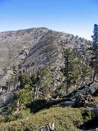
![View of North Backbone and Mount Baldy]() Ridge back up to Baldy
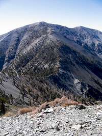
Ridge back up to Baldy![View of Pine Mountain]() View of Pine Mountain
View of Pine Mountain
Making a long, and potentially dragging story short, we made it to the summit of Pine Mountain. The views were spectacular. We had a great view of San Antonio Ridge showing the hike I want to do from Mount Baldy to
Iron Mountain. There was a large stash of food and water in the rock circle on the summit of Pine Mountain. I was happy to dump out my fermented gatoraid (which I was keeping as emergency fluid) and take the water instead. On our way back we ran into a hunter. He seemed out of place, I was not aware they were allowed to hunt in the National Forest. He said he saw 8
Big Horn Sheep (he was hunting deer, not sheep) over the next ridge near fish fork creek. We looked but could not spot the sheep.
The climb back up to Dawson Peak is not too bad and we made good time. We went all the way to the summit this time, taking a short detour off the main trail. The views were not as spectacular as Pine Mountain, but a nice peak. There was another couple hanging out at the summit, and we chatted for a bit, talking about the hike I want to do from
Mount Baldy to Iron Mountain. After a short while we headed back down the ridge in order to ascend back to Mount Baldy (see photo). The 1200 feet back to Baldy was a slog. At one point I was resting on a rock, "dead" tired, and a bunch of crows started circling above me. Seriously. Tom saw them from above and called at me making sure I was OK. I got back up, convinced the crows I was not a potential meal, and trudged back to Baldy. The total mileage from Baldy to Pine and back was 5.25 miles with 3070 ft elevation gain, taking 4 hours. Definitely not a good time, but I was happy to complete our original goal.
Down to Baldy Notch and home
I felt fine going downhill and partially ran down to the ski lodge, getting there quickly. I was motivated to get there quick because I was so hungry and craving a cold Pepsi. After my sandwich and Pepsi, Tom arrived at the ski lodge (he climbed Mount Harwood as a side trip) and we took the easy way down via the chair lift. A great hike, even through I was performing below par. The weather could not have been better, the temperature was perfect and there was not a cloud in the sky the entire day.
![San Antonio Ridge Pamoramic]() Panoramic of San Antonio Ridge
Panoramic of San Antonio Ridge


Comments
Post a Comment