
|
|
Mountain/Rock |
|---|---|
|
|
40.40980°N / 115.9883°W |
|
|
Elko |
|
|
Hiking |
|
|
8747 ft / 2666 m |
|
|

Overview
Prominence peakbagging isn't an overly popular activity in Nevada but by being involved in it, you can visit places where the tour books and guide books never go. Places that have a special beauty and attraction of their own and are worthy of being highlighted. Elliot BM, the highest peak in the Pinyon Range of north central Nevada is one of these special places. By journeying there, my wife and I had a sense of adventure and an awareness that we were a couple rare visitors to a rarely visited area. On our visit, we encountered some horsemen that were checking on their cattle, strays that had separated themselves from the main body of animals.After you leave the pavement of highway 278 south of Carlin, you enter a realm of dirt roads and jeep tracks. A strong vehicle with good tires is a necessity but this allows you to enter this interesting arena. While this is close to being a drive up, it still requires a long drive on a fairly rough dirt jeep track and is smack in the middle of cattle country. I guess what intriques me about these Nevada peaks is that they are rarely visited, even with a jeep road nearby as was the case for this one. Why was I making the effort to get to this one? As mentioned at the beginning, it is one of Nevada's prominence peaks that has over 2000 feet of prominence.
This one comes in at #126 on the list with 2247 feet of prominence. On the summit I found a central benchmark and a register. The register contained just a few names in the ten years since it was originally placed. Mostly other prominence seekers had signed in but a hunter or two added their names as well.
What if you don't have a high clearance vehicle? You can do as SP member BradB did, you can hike there. See his report here.
Getting There
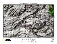
If you are heading west on I-80, take the central Carlin exit, go west to Hwy 278 and then south on Hwy 278. If coming from the west, take exit 279 off of I-80 that is just before Carlin's central exit About 20 miles south of Carlin, watch for mileposts 66 and 67 and turn east at virtual milepost 66.9, onto an unsigned road (this is Trout Springs road as seen on Benchmark's map book)and zero your odometer. Using Dennis Poulin's odometer readings (yours may vary), stay right at 0.4 and 0.8 then straight at 3.1. At 4.3 cross a creek and then stay right at 5.8 and 7.0. At 9.2 cross a creek where high clearance 4WD may be necessary. At 9.7 go through a gate and at 10.6 take a right turn. At 12.3 go through an open gate and at 12.7 reach a saddle and stop. The road actually continues steeply down the other side, but this saddle is at 8565 ft and it is just a short walk over to the Elliott BM.I have included maps with some waypoints but Dennis's mileage worked for me.
 |  |  |
Red Tape & common sense.
The peak is located on BLM land and is used primarily for cattle grazing. Be sure to open and close gates as you find them as the road passes through private ranching land along the way. Be respectful of the private property and do not drive on these roads during wet weather as they may become impassable. Cell phones may not work in this area and it is best to be prepared for any emergency. A full tank of gas (top off in Carlin or Elko), adequate tires with a good spare or two and plenty of water (it gets very hot in the summer) are wise precautions. Let someone know where you are going.The summit
I found a glass jar register and some benchmarks on the summit, an easy walk up from the nearby jeep road. After my visit in 2011, another 8 or so peakbaggers have visited this peak. One visit in 2012, another in 2013, three visited in 2014 and three so far in 2015. You can find a good listing of most of these people at peakbagger.com as well as Lists of John.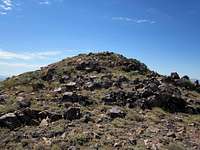 | 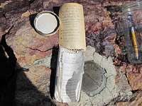 |  |
 |  |  |
Camping
No organized campgrounds are in the area and while you could most likely car camp using the leave no trace ethics, there should be no need to camp sincethis one is not going to take up most of a day. Motels are available in Carlin and nearby Elko.