
-
 26698 Hits
-
 83.1% Score
-
 16 Votes
|
|
Route |
|---|---|
|
|
46.38296°N / 9.90721°E |
|
|
Mountaineering |
|
|
Summer |
|
|
One to two days |
|
|
Walk-up to III on UIAA scale, ice and snow ridges |
|
|
Overview
Piz Bernina Normal route from Campo Moro (Italian Normal route)
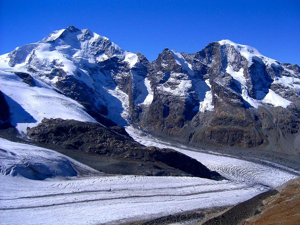
Piz Bernina 4049 m is a famous summit located in the namesake alpine range, playing a particularly important role, being the Easternmost alpine Fourthousander. It's also the only one situated in the Eastern Alps. This route is the most popular Piz Bernina ascent. It begins on Campo Moro (1990m), high on the southern slopes of Bernina group, above Valmalenco valley in Italy. Because of two large dams and reservoirs Campo Moro is reachable by car. Very attractive road winds in endless number of bends and tunnels through beautiful scenery as you gain 1700m from Sondrio. Just 2 minutes above the parking is Rif. Zoia (2021m), which stands on the panoramic shoulder between larch trees. View towards south is beautiful, especially towards mighty Monte Disgrazia (3678m), which is more towards west. Zoia hut is great place to sleep over if you can't get here early in the morning to start the Bernina approach. Since it is at the end of the road it is not crowded so you don't need to make early reservation.
Route from Campo Moro begins at 1990m but it is not easy. On the contrary it is tough and long. Altitude difference to Piz Bernina is more than 2000m. On the first day you have to reach Marco e Rosa hut (3609m) (reservation is obligatory), sleep over and climb the summit in the morning and return to the valley. This is how it is mostly done. Rarely can someone do it in a day because climb from Marco e Rosa hut to the summit is technical and takes quite some time. Summit is just 400m above it but some people need 4-7 hours to return to the hut.
Not even reaching Marco e Rosa hut is easy task. After you successfully tackle crevasses on upper Scerscen glacier there is final ferrata section that includes 300m vertical gain with steep rock climbing and few showers from waterfalls.
Conclusion is that this is beautiful route which has everything. It will take you from greenery of Campo Moro to ever lasting snow and glaciers of Bernina group. On the way you'll see some amazing scenery: cows on green pastures, giant granite mountains in full spectrum of colors, endless streams cascading from glaciers, deep crevasses and in the end you'll climb steep cliffs high above glacier.
Route can be divided into 4 sections:
Section 1) Campo Moro (1990m) – Rif.Carate Brianza (2636m): 2h
Section 2) Rif. Carate Brianza (2636m) – Rif. Marinelli Bombardieri (2813m): 1.30h
Section 3) Rif. Marinelli Bombardieri (2813m) – Rif. Marco e Rosa (3609m): 4-5h
Section 4) Rif. Marco e Rosa (3609m)– Piz Bernina (4049m): 2-3h
 |
 |
 |
 |
Getting there
Center of the region is Sondrio town (300m), which lies deep below Bernina group in Valtellina valley. Sondrio is most easily reached from Milano. From Milano head towards north or Monza and Lecco towns on the shore of the Como Lake and further to Sondrio (136km). Soon after the western entrance in the Sondrio there is junction (rotation) where signs point you towards left and Valmalenco valley. After 12.6km road reaches picturesque Chiesa in Valmalenco (960m) village which is center of the valley. Few hundred meters after the junction towards the center of Chiesa there is another junction towards right. Follow the signs towards Franscia. Road narrows and ascends above Val Lanterna in many sharp bends and tunnels, which were dig in pure granite, till you reach its end at Campo Moro.
Section 1 - Campo Moro 1990m – Rif. Carate Brianza 2636m (2 hours)
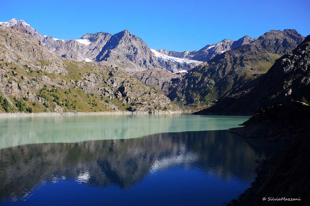
From the parking on Campo Moro follow the signposts and descent towards the dam of the lower lake (asphalted road). Once you get over the dam marks descent in 3 sharp bends towards the meadows below the dam (10mins). Here is also a parking lot at the end of macadam road which ascends from Franscia. Many people also start here.
From parking path turns left and ascends through the larch trees using steep shelf which cuts wild slopes of Sasso Moro (3108m). In some 20mins you’ll reach the descending ridge around which path turns right and levels. From this spot is beautiful view back towards Campo Moro, lake and Piz Scalino (3323m) on the other side of the valley.
Path for quite some time goes relatively straight, gaining almost no altitude, while it gets deeper into the valley. Below are pastures of Alpe Musella while in front you can see Rif.Carate, just below the pass which is high above. That is your direction. One hour from Campo Moro trail begins to ascend again, over the open grassy and rocky slopes, till you reach the refuge (another hour). Above are wild peaks of Cime di Musella (3088m).
 |
 |
 |
Section 2 - Rif. Carate Brianza 2636m – Rif. Marinelli Bombardieri 2813m (1.30 hours)
From Carate refuge trail ascends shortly to Forbici pass. From it view literally explodes towards the north and few of the giants of Bernina group: Piz Roseg (3937m) & Piz Scerscen (3971m). Piz Bernina is just little bit further to the right, hidden by a descending shoulder.
Path shortly goes straight and then begins to descend. After you pass steep rocky shoulder Piz Bernina joins the panorama. After some 20mins of descending from the pass, path turns right into the valley behind Musella peak. Up in the cliffs you can see Marinelli Bombardieri hut (2813) while in front of you is Caspoggio glacier. Once you pass a stream which drains the lake that is on the right path begins to ascend. First gradually by the stream on the right till it turns sharply left and ascends steeper in many bends. After 35mins of ascending from the lake you’ll reach Bombardieri hut.
 |
 |
 |
 |
 |
Section 3 - Rif. Marinelli Bombardieri 2813m – Rif. Marco e Rosa 3609m (4-5 hours)
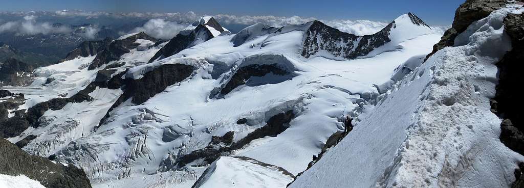
East of the hut trail begins to ascend towards upper Scerscen glacier. First part will take you over steep slopes, made of broken boulders. Marks ascent steeply, going over the muddy stream few times or by it. In some 45mins you’ll reach western Marinelly pass which is eastern edge of the huge plateau which stretches below the peaks of Bernina group and on which Vedretta di Scerscen Superiore or upper Scerscen glacier lies. In the distance you can see Marco e Rosa hut, on the pass right of Piz Bernina. Below it are steep cliffs and part of glacier squeezed between giant cliffs of Piz Scerscen and Piz Bernina. That is where you are heading.
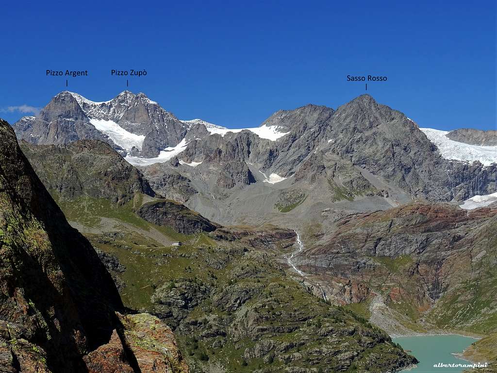
From the pass there is small descent to the glacier. Ice is mixed with fallen boulders so wait with crampons till you reach pure ice little bit further behind. This is relaxing section because traversing the glacier is almost horizontal. Above are mighty cliffs of Piz Argient (3945m) & Cresta Guzza (3869m) while in front are Piz Roseg (3937m), Piz Scerscen (3971m) & Piz Bernina (4049m) which is least impressive among these mighty peaks. After an hour of almost horizontal glacier walking which includes crossing over the huge boulder tongue which covers the ice in the middle of glacier, track begins to ascend, ever more steeply. Marco e Rosa hut is high above and you are probably tired as you reach large crevasses near the end of huge couloir between Scerscen and Bernina. After crossing a bridge above huge crevasse track turns right and steeply ascends to the edge of the cliffs, almost 2 hours from the pass and 3 hours from Bombardieri hut.
This is the place to remove crampons as steep climbing begins. Along the trail are fixed chains. Without them this would be very exposed climbing with II and almost III (UIAA) degree on spots. On one spot waterfall falls over the trail and you can't avoid nice cold shower. After 1.15h of climbing Marco e Rosa hut appears in front of you.
From Campo Moro you'll probably need between 7-9h.
 |
 |
 |
 |
 |
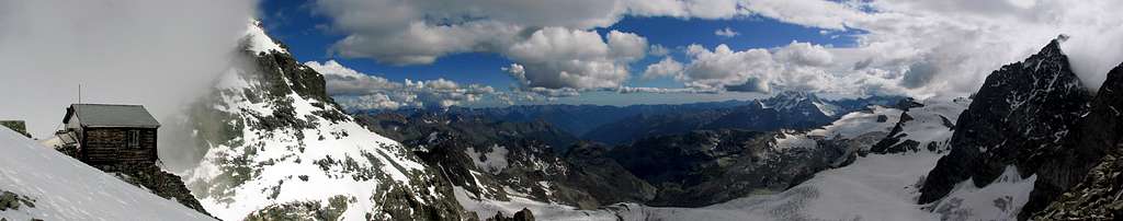
Section 4 - Rif. Marco e Rosa 3609m - Piz Bernina 4049m ( 2-3 hours)
Few meters above the hut is the edge of the glacier and place to put the crampons on and rope with your partners. Some 40mins of very steep ascent is in front of you till you reach the summit rocks and cliffs. Here you have to remove the crampons and begin to climb steep broken slope of granite blocks. Be careful not to start slide of the rocks. Below the ridge there is very steep section to climb (II-III) which is around 10m high. Once you reach the ridge trail turns left and continues to climb steeply towards the Italian Bernina peak (4020m) (II-III). Once on the peak it is time to put crampons again, knife sharp snow-ice ridge is in front of you with huge depths on both sides. Once you are safely on the other side there is only easy rock (or snow) ascent to the summit.
How much time you'll need for this section depends on your skills and conditions. This is only for experienced mountaineers who know how to climb III degree and use rope and climbers. It is much tougher to descent and on few spots you have to rappel.
 |
 |
 |
Red Tape
No particular restrictions in climbing and hiking.
Huts

- Rifugio Marinelli-Bombardieri 2818 m
Situation: High Scerscen Valley
Owner: CAI Sez.Valtellinese
Guardian: Giuseppe Della Rodolfa Guida Alpina UIAGM
Open: June-September
Size: 100 persons
Getting There: Campo Moro (Val Malenco) Path CAI n. 2
Hut's phone: +39.0342.511577 Hut's reservation phone: +39.347.5200146
Mail: rifugiomarinellibombardieri@gmail.com

- Rifugio Marco e Rosa 3609 m
Situation: South of Piz Bernina (normal route)
Owner: CAI Sez. Valtellinese Guardian: Giancarlo Lenatti Open: end of June till 20th of September Size: 48 beds (+winter 50) Getting there: From Coax Hut (4 hours: Sella Glacier - Sella Pass - Superior Scerscen Glacier), Boval Hut (4'30 hours: Morteratsch Glacier), Rifugio Marinelli-Bombardieri (3 hours: Marinelli Pass - Superior Scerscen Glacier) or, from Francia via Campo Moro: 1 hour, from Francia via Alpe Foppa: 2'30-3 hours.
Hut's phone: +39 (0)342-515370 Mobile (Hut's reservation phone): +39 (0)342515 370
When to climb
Best season goes from July to September
Meteo
Switzerland Forecast
Meteo Lombardia
Guidebooks and maps
Guidebooks


"Il grande libro dei 4000 - Vie normali e classiche" by Marco Romelli, Valentino Cividini - Idea Montagna Editore, 2015
"Tutti i 4000” – L’aria sottile dell’alta quota" - CLUB 4000 CAI TORINO – Vivalda Editori
"The 4000 of the Alps" - by Richard Goedeke (CAAI) – All the normal routes to the 4000m. summits of the Alps – Libris Edition
"Bernina" - N. Canetta, G. Miotti - Collana Guide dei Monti d'Italia CAI-TCI
"Bernina & Bregaglia Selected Climbs" - Lindsay Griffin ISBN: 0900523603 Alpine Club (http://www.alpine-club.org.uk/)
"Berninagruppe" Gebietsführer für Wanderer, Bergsteiger und Hochalpinisten - Walther Flaig ISBN: 3763324178 Bergverlag Rudolf Rother, München
Maps "Bernina-Sondrio" - Kompass 1:50.000
"Julierpass" - sheet 268 - CNS 1:50.000
"Bernina" - sheet 1277 - CNS 1:25.000
External links
- Club4000 UIAA list of the 82 Fourthusanders and 64 minor ones
- Piz Bernina at www.4000er.de Images, routes, coordinates and more information about the highest peaks of the Alps
- Weather
- Swissgeo Piz Bernina maps
- Pontresina