Wetlińska Meadow of Bieszczady Mountains
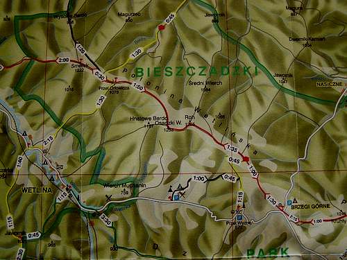
![Map of Wetlinska Meadow massive]() Map of Wetlinska Meadow massive
Map of Wetlinska Meadow massive
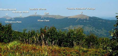
Połonina Wetlińska (Wetlińska Meadow) is the second highest mountain massive in the Bieszczady Mountains of Poland. It runs for 12 kilometres from west to east starting at the Wetlinka River Valley and ending at the Prowcza River Valley.
There is a "red" trail across the entire ridge of the masive, which takes about 6 hours to complete. The route travels in westerly direction and climbs to the top of Mount Smerek (1222 m) . It later reaches Orlowicza Pass (1078 m), which divides Mount Smerek and Wetliñska Meadow. Other high points along Wetlinska massive worth mentioning are Osadzki Wierch (1253 m), Roh (1255 m) and Point 1228 m. There is a mountain refuge located on Point 1228m and it is called „Chatka Puchatka”. It is the highest refuge in the Bieszczady Mountains.
Wetlinska Meadow can be also reached by taking the "yellow" trails. They ascend its steep southern slope or the more gentle northern slope.
All of the trails meet at Orlowicza Pass. This mountain pass was named after the author of the first guidebook about the Bieszczady Mountains.
Wetlinska Meadow Massive lies within Bieszczady National Park. This area offers various hiking routes that are scenic and pleasant and therefore it deserves a separate album.
![Wetlinska Meadow Massive]() Wetlinska Meadow Massive
Wetlinska Meadow Massive![Mount Wetlińska Meadow]() Mount Wetlińska Meadow
Mount Wetlińska Meadow
Comments
No comments posted yet.