
-
 2277 Hits
-
 81.84% Score
-
 14 Votes
|
|
Mountain/Rock |
|---|---|
|
|
45.48294°N / 7.16946°E |
|
|
9944 ft / 3031 m |
|
|
Overview
Small but acute and elegant Summit situated between the Costa of Menta or Crête de Menthe (2.822/2.926m) to the West-northwest and the Colle of Ferauda or Col de Ferande (2.926/3.022m) to the East. An easy climb was reached in 1855 by Gottlieb Stuber with the mountain carrier Zahler who made the crossing from North to South, ie from the Alpe of the Nivolé or Nivolet (2.407m) to that of Serrù (2.390m), now in Canavese Area (Piedmont). It offers panoramic views of the Gran Paradiso Group (4.061m) and in particular the nearby Punta Fourà (3.411m) to the East and and towards Punta Basei (3.338m), now at the border with the Rhemes Valley on the opposite watershed. In front of and towards Valsavarenche stretches the verdant Nivolé Plateau, perhaps the tallest and longest tableland in Europe (over 10 Kilometers).
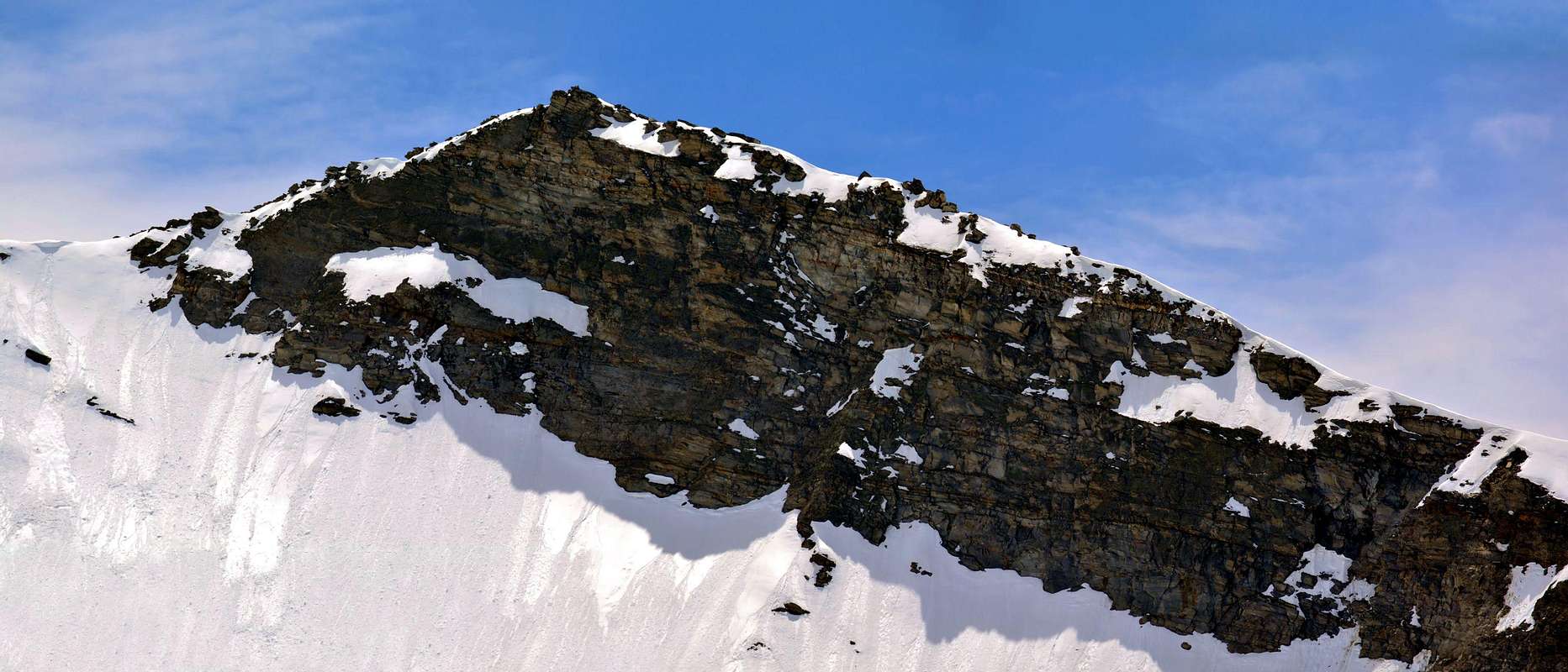
Piccola ma acuta ed elegante Sommità posizionata tra la Costa di Mentà o Crête de Menthe (2.822/2.926 m) ad Ovest-nordnovest ed il Colle di Ferauda o Col de Ferande (2.926/3.022 m) ad Oriente. Di facile salita fu raggiunta nel 1855 da Gottlieb Stuber insieme al portatore Zahler che effettuarono la traversata da Nord a Sud, cioè dall'Alpe del Nivolé o Nivolet (2.407 m) a quella del Serrù (2.390 m), ormai nella Zona del Canavese (Piemonte). Esclusivamente di interesse panoramico, offre belle viste sul Gruppo del Gran Paradiso (4.061 m) ed in particolare sulla vicina Punta Fourà (3.411 m) ad Est ed al confine con la Valle di Rhemes e sulla Punta Basei (3.338 m), sullo spartiacque opposto. Di fronte e verso la Valsavarenche si allunga il verdeggiante Altopiano del Nivolé, forse il più alto e lungo in Europa (oltre 10 Kilometri).
First Ascents
- First on the summit: Unknown, but probably by Gottlieb Stuber with the mountain carrier Zahler, (Aug 14th, 1855) witn traverse North/South.
- In Winter: Unknown.
- Eastern Crest (from Ferauda Hill or Normal Route from Nivolet Alp): Unknown.
- Southwest (Standard Via from Piedmont through the P.N.G.P. Cabin of Bastalon Pasture): Unknown.
- North-northwest Face of Costa Mentò or Crête de Menthe (directly from the Higher Nivolet Lake) and traverse: : Osvaldo Cardellina and Marco Cossard, (Sep 03th, 1973).
Getting There
BY CAR:- From France: through the Mont Blanc Tunnel or the Col du Petit Saint Bernard: you can drive on SS.26, following directions for Aosta and, before arriving in Villeneuve, turn right towards Introd. Alternatively, you can take Motorway A5 (at Courmayeur or Morgex) and exit at Aosta Ovest.
- From all the other directions: get to the Aosta Ovest exit of Motorway A5. Then drive on SS.26 Aosta, in the direction of Courmayeur; just after Villeneuve turn left towards Introd.
- Aeroporto "Corrado Gex" Saint Christophe (Aosta).
Approach & Route
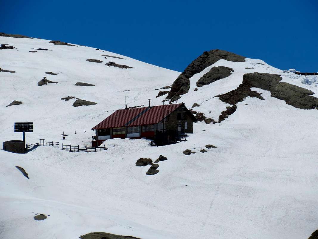
From Pont di Valsavarenche (1.960m) a comfortable mule track n° 3A starts just behind the "Hotel. Of Gran Paradiso" Toward West into the narrow valley of the Doire Stream of Nivolè and, along a ramp, get the Croce de la Roley (2.313m), (good panoramic point with wooden benches and tables). Follow zigzagging into the big banks of rock, polished by ancient glaciers, entering the Nivolè Plain, (a big highland long more than 6km ending with two fine lakes (2.526m and 2.537m) and the Nivolè Pass (2.612m) joining the Valsavarenche with the Ceresole Valley (Piemonte) Two Refuges here: Savoia (2.534m) and Chivasso (2.604m). Along this plain up to the many twists of the Doire Stream and, before the Montagna Grand Collet (2.409m). From the "Montagna Grand Collet" am gone through the torrent reaching immediately after the Mountain of the Nivolè (2.399m). Staying to East of the torrent it arrives at the Inferior Lake of the Nivolè (2.526m) and then with Southeast direction to the Superior one (2.938m) and on the easy and simple West Glacier to reach the Ferauda o Ferande Hill (3.033m). With direction West it ascend the easy and very rotten crest on a wide slope and to reach the Shoulder Northwest (3.012m), after to overcome the altitude 3.065 meters and the subsequent large saddle 3.020 meters; therefore following the thread arrives at the cairn of traditional peak, after bypassing the last altitude of 2.996 meters. (II°+; 3h'30/4h'00).
 |
 |
 |
 |
 |
Da Pont di Valsavarenche (1.960 m) prendere la comoda mulattiera n° 3A, che parte subito dietro "l'Albergo del Gran Paradiso"; salire verso Ovest lo stretto valloncello della Doire (torrente) del Nivolè e, con una rampa finale, raggiungere la Croce de la Roley (2.313 m), ottimo punto panoramico e fotografico con panche in legno e tavoli. Si continua a serpentina tra grandi banconate di splendida roccia, levigata dall'antica erosione glaciale, "entrando" nel Pian del Nivolè, grande altipiano di oltre 6 km utile al pascolo; al termine dello stesso l'omonimo Colle (2.612 m), preceduto da due bei laghi (2.526 m e 2.537 m) porta nella Valle di Ceresole in Piemonte (Rifugi Savoia (2.534 m) e Chivasso (2.604 m) proprio al colle). Percorrere un tratto del famoso pianoro sin dove la Doire effettua numerose anse, raggiungendo la Montagna Grand Collet (2.409 m). Dalla Montagna Grand Collet si attraversa il torrente raggiungendo subito dopo la Montagna del Nivolè (2.407 m). Restando ad Est del torrente si giunge al Lago Inferiore del Nivolè (2.526 m) e poi con direzione Sud-Est al Superiore (2.938 m). Sul facile e semplice Ghiacciaio Occidentale di Punta Fourà raggiungere il Colle di Ferauda o Ferande (3.033 m). Con direzione Ovest salire la facile e molto rotta cresta su un largo pendio e raggiungere la Spalla Nordest (3.012 m), dopo aver superato la quota 3.065 e la larga sella 3.020 metri; quindi, seguendo il filo, si giunge allo ometto di vetta tradizionale, dopo aver scavalcato l'ultima altitudine di 2.996 metri (II°+; 3h'30/4h'00).
Difficulty
From F to (in winter for BS= good skiers) F+.Da Escursionismo o con racchette da neve oppure sci.
 |
 |
 |
 |
 |
Red Tape
Within the borders of the P.N.G.P. (Parco Nazionale del Gran Paradiso), at the moment dogs generally are not allowed, except on a couple of trails, and camping is forbidden (except for climbers from sunset till dawn). No fees are due.Campings
- Wild camping in the Parco Nazionale del Gran Paradiso is strictly forbidden!!!
Huts

Webcam
- WEBCAM on Aosta Valley:
- Webcam
Mountain Condition
- You can get meteo information at the official site of the Regione Valle d'Aosta:
- Valle d'Aosta Meteo
Books and Maps
BOOKS:- "I Rifugi della Valle d'Aosta" di Stefano Ardito, Ed. Guide iter, Febbraio 2003.
- "Parco Nazionale del Gran Paradiso" di Stefano Ardito, Ed. Guide iter, Novembre 2001.
- "Guida delle Alpi Occidentali", di Giovanni Bobba e Luigi Vaccarone C.A.I. Sezione di Torino Volume II (parte II), 25 Maggio 1896.
- "Gran Paradiso", A. Gegenfurtner, G. Klotz, F. Müller, Ed. Bergverlag Rudolf Rother, Monaco 1980 (in tedesco).
- "Gran Paradiso", G. Klotz, Ed. Bergverlag GmbH Rother, Monaco 2005 (in tedesco).
- "Diari Alpinistici" di Osvaldo Cardellina e Indice Generale accompagnato da Schedario Relazioni Ascensioni 1964-2019 (inediti).
- "Rifugi e bivacchi in Valle d'Aosta", di Cosimo Zappelli aggiornata da Pietro Giglio, Musumeci Editore, Luglio 2002.
- "Guida della Regione Autonoma Valle d'Aosta" di Mario Aldrovandi,Ed. S.P.E. di Carlo Fanton, Torino 31 Dicembre 1964.
- "Guida dei Monti d'Italia-Gran Paradiso Parco Nazionale" E. Andreis, R. Chabod, M. C. Santis, Club Alpino Italiano/Touring Club Italiano, prima Ed. 1939; seconda Ed. 1963; terza Ed. 1980.
 |
 |
 |
 |
 |
MAPS:
- Kompass "Gran Paradiso Valle d'Aosta Sentieri e Rifugi" Carta Turistica 1:50.000.
- L'Escursionista "Valsavarenche Gran Paradiso Carta dei Sentieri" (n° 9) 1:25.000.
- Meridiani Montagne "Gran Paradiso" 1:25.000.
- Enrico Editore Ivrea-Aosta "Gruppo del Gran Paradiso" 1:50.000.
- L'Escursionista "Valle di Cogne Carta dei Sentieri" 1:25.000.
- L'Escursionista "Tour de la Vallée de Cogne Grand Paradis" 1:25.000.
- I.G.C. Istituto Geografico Centrale "Parco Nazionale del Gran Paradiso" 1:50.000.
- Studio F.M.B. "Gran Paradiso" Bologna 1:50.000.
- I.G.C. Istituto Geografico Centrale Torino "Valsavarenche Val di Rhêmes Valgrisenche P.N.G.P.", 1:25.000.
Important Information
- REGIONE AUTONOMA VALLE D'AOSTA the official site.
- FONDAZIONE MONTAGNA SICURA Villa Cameron, località Villard de la Palud n° 1 Courmayeur (AO) Tel: 39 0165 897602 - Fax: 39 0165 897647.
- SOCIETA' GUIDE ALPINE DEL GRAN PARADISO Comune di Valsavarenche.
- A.I.NE.VA. (Associazione Interregionale Neve e Valanghe).
Useful Numbers
- Protezione Civile Valdostana località Aeroporto n° 7/A Saint Christophe (Ao) Tel. 0165-238222.
- Bollettino Meteo (weather info) Tel. 0165-44113.
- Unità Operativa di Soccorso Sanitario (Emergency Medical Assistance). Phone: 118.