
|
|
Mountain/Rock |
|---|---|
|
|
47.73450°N / 18.92215°E |
|
|
Pest |
|
|
Hiking |
|
|
Spring, Summer, Fall, Winter |
|
|
2100 ft / 640 m |
|
|
Overview
 The "north face" of Prédikálószék from the feet of Szent-Mihály-hegy The "north face" of Prédikálószék from the feet of Szent-Mihály-hegy |
Prédikálószék (whose name means "pulpit") is one of the highest summits of Visegrád Mountains. However, its fame derivates from other reasons.
First of all, it offers one of the best panoramas in Hungary. Looking north from the summit rock (the pulpit), you have a complete view of the picturesque Danube Bend. About 500 meters below you, the wide river takes a pronounced curve around the Szent-Mihály-hegy (St. Michael Mountain). Behind it, in the distance, you can see the mountains of Börzsöny. Towards the east (on your right) you will notice the scenic castle of Visegrád, which is also an important historic place.
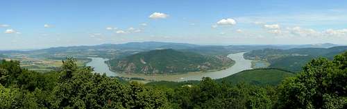 The Danube Bend and Szent-Mihály-hegy viewn form the top of Prédikálószék
The mountain was also involved in a serious environmental-political issue. A few dozen years ago, the construction of a dam was planned in the Danube bend in cooperation with the former Czechoslovakia, later Slovakia (upstream from its bend, the Danube is a border river). As part of the complex hydroelectric system, an upper water reservoir was planned to be built on the top of Prédikálószék, along with a pump station. Without going into the details of the issue, due to the strong civil protest, the construction of the Hungarian dam was cancelled in 1989, and Prédikálószék was left untouched.
Finally, a not less interesting feature of this mountain is its rocky ridge formation, which is undoubtly among Hungary's most scenic ones. There is a series of bizarre towers on the mountain's NW ridge, called Vadálló kövek.
Vadálló-kövek
 Vadálló-kövek from the neighbouring ridge
It's somewhat hard to translate the name of Vadálló-kövek in a few terms - the meaning of the Hungarian expression is "observation rocks of wild animals" - perhaps "sentinel rocks" will do in English. The dozen or so smaller and larger boulders and towers are built up of volcanic conglomerates and were carved to shape by erosion processes. They are located between around 500-600 m altitude.
The majority of the rocks are located on top of the ridge, the most distinct ones have their proper names as well ("throne of Árpád", "upside-down exclamation mark", "suspended rock", "maul", "wide tower", "stump"). There are a few remarkably tall towers in the side of the ridge as well ("monk and nun", "four fingers").
Although not included in the group of Vadálló-kövek, there are a few further rocks of similar kind on the neighbouring ridge towards the south. These offer nice view of the Vadálló-kövek ridge, although there is no marked tourist path leading to them.
 |
 |
 |
 |
 |
 |
 |
 |
Getting There and Camping
| Quite easy... Dömös village has frequent bus connection with Budapest. There are buses to Dobogókő as well, starting from Pomáz village (located north of Budapest), but it's much nicer to hike up there from either Pomáz or Pilisszentkereszt. There is a camping place at Dömös, by the Danube riverbank. At Dobogókő, hikers usually sleep in the Eötvös Loránd Hut rather than the more fancy hotels. |
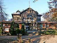 Eötvös Loránd Hut Eötvös Loránd Hut |
 The old hostel, now museum The old hostel, now museum |
Routes
Prédikálószék can be approached from two directions:
 The lower part of Vadálló-kövek
From the north, start at Dömös village. Follow the signs towards Rám-szakadék (three marked trails begin here: red, yellow and green stripes).
After a while you leave the last houses of the village and will have to cross the stream. A short walk follows in the woods, but still along the stream. Soon you will reach a spring with benches. By the spring you will find the trailhead of the red triangle hiking trail towards Vadálló-kövek and Prédikálószék.
From here on, the footpath continuously ascends, occasionally in a quite inclined fashion (compared to an "ordinary Hungarian hiking trail"). The terrain gradually changes from forest to rocky surface, finally reaching the bare ridge of Vadálló-kövek. Having left behind this beautiful ridge, the trail returns into the forest, and soon reaches the summit of Prédikálószék.
 On the ridge of Vadálló-kövek On the ridge of Vadálló-kövek |
 Fall scenery of Vadálló-kövek Fall scenery of Vadálló-kövek |
 Vadálló-kövek in winter Vadálló-kövek in winter |
From the south/east there are several points to start from, probably the most popular is Dobogókő, another fine lookout point, where a century ago only a modest hikers' hut stood, nowadays an often crowded tourist place with bus service, motorcycles, buffets, etc... From here follow the red triangle sign, which leaves Dobogókő towards the east along with the blue stripe (better marked), later departing from it towards the north, descending into a valley, then ascending north-west onto Prédikálószék, doing a semi-circle-shaped route.
 Prédikálószék (to the right) viewn from Dobogókő
Given the vicinity of the Rám gorge, it is a good idea to make a bigger loop starting from Dömös, going up the Rám gorge, stopping by Dobogókő, getting over to Prédikálószék, and descending back to Dömös via the Vadálló-kövek. The hike is about 20 km long and involves about 900 m of total elevation gain/loss - check out this page for a map.
Red Tape


Prédikálószék and Vadálló-kövek are core areas of the Duna-Ipoly National Park, belonging to the strictly protected Biosphere Reserve. Entry to the area is free of charge.
As several rare and threatened plants live especially in the rocky areas, therefore it is essential to keep on marked paths and not to disturb their habitat.
For safety reasons, climbing the towers of Vadálló-kövek is officially not allowed, though the easier ones are often scaled from the trail's side by hikers, for the view and of course, for the glory...
Maps
Paper maps
See the Parent page.
Online maps
A powerful free online map is being developed by the Open Maps Project for the area of Central Europe. If you are not familiar with the area or want to skip the zooming job, you can get a quick close-up view of Prédikálószék's area, follow this permalink.