
-
 11905 Hits
-
 82.33% Score
-
 15 Votes
|
|
Mountain/Rock |
|---|---|
|
|
46.50290°N / 10.62290°E |
|
|
10908 ft / 3325 m |
|
|
Overview
Geographical Classification : Eastern Alps > Ortler / Cevedale Group > Punta Beltovo / Schöntaufspitze
Schöntaufspitze is one of the most popular destinations in the Ortler – Cevedale Group.Though you are mostly alone wherever you go in the group you can be sure to meet a bunch of people on Schöntaufspitze. The reason for this is the very easy accessibility: from Sulden / Solda a cablecar runs up to 2573m to Schaubachhütte / Rifugio Citta di Milano so that the remaining 800m of altitude don’t pose any difficulties. It is actually the easiest 3000er that I have ever climbed.
The mountain actually is composed of two summits which in German are called Vordere S. and Hintere S.. I only found the Italian name for the higher Hintere Schöntaufspitze: Punta Beltovo di Dentro. Vordere Schöntaufspitze is some 250m lower and rarely climbed (at least in summer). It just isn't such an attractive destination though views must be still pretty breathtaking.
There is a second, more serious ascend route from Martelltal / Val Martello along the long Madritsch Valley / Val Madriccio. It does not pose too many difficulties but covers more than 1300m of elevation.
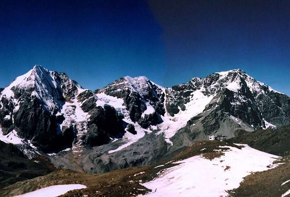
The main reason for the popularity of Schöntaufspitze, however, is the perfect view towards the central Ortler Group. Königsspitze / Gran Zebru, Monte Zebru and Ortler / Ortles form a perfect trinity much like the Eiger, Mönch, Jungfrau Trinity in the western alps at Grindelwald. And it is from the east that you can admire this trinity best. And as an encore, there are the glacier covered twin Cevedale peaks just to the east of it – a pure looking fest.
But: the Ortler/Cevedale Group is composed of more than these highest summits and to the northeast of Cevedale there is a long chain of mountains, starting from Hasenöhrl / L'Orecchia di Lepre along Orgelspitze / Punta di Lasa, Vertainspitz / Cima Vertana, etc etc.etc. And together they prevent you from looking towards Ötztal Alps in the north which might be an interesting viewing destination as well. (I didn’t even look once there…)
 |  |  |  |
The Summit Panorama
You can see a large part of the Ortler-Cevedale Group from Schöntaufspitze as well as the Ötztal Alps and the Sesvenna Group. But to tell you the truth: the trio Ortler, Zebru, Königsspitze and the twin peak of Cevedale require all of your attention. You won’t be able to see much more…..
 |  |  |
Getting There
The best trailhead for this mountain is at Sulden / Solda on the westernmost part of Vinschgau Val Venosta. Another trailhead is the end of Martelltal /Val Martello. To reach these destinations the following directions apply.
From Italy
Take the Brenner motorway (A22) which you leave at Bozen / Bolzano south. Take S38 (Vinschgauer Staatsstrasse) northwards towards Meran /Merano). The road follows the Etsch / Adige Valley into Vinschgau / Val Venosta. Follow the road westwardsuntil you reach Laatsch / Laces. A little after the village the road into Martelltal turns off to the left. Drive on through to the end and start your ascent from Enzianhütte / Rifugio Genziano.
For the Sulden trailhead get further along on S38 to Stilfs. After Stilfs at Gomago turn left into Sulden Valley. Again drive through to the end to start your ascent from Innersulden / Solda di Dentro.
From Austria
Take Inntalautobahn (Motorway A12) westward from Innsbruck to Landeck. At Landeck turn onto road 180 which winds its way upwards the upper Inn valley towards Nauders. Between Nauders and Reschen /Résia you cross the border and are directly on the shore of Reschensee / Lago di Résia. Follow the main road down towards Laatsch / Laces for the Martell trailhead or to Laas for the Sulden trailhead. Turn right in either case and follow the decriptions above into the respective valleys.
From Switzerland
Take motorway A3 from Zürich or E43 from Bregenz southwards in the direction of Chur. Shortly after the motorways meet turn off onto road 28, direction Davos. Behind Davos at Susch the road splits (27 / 28). Take the southern road (28) over Ofenpass (Passo dal Fuorn) into Vinschgau (there take the main road downwards (east)). Again at Laas or Latsch turn right into the respective destination valleys.
 |  |  |  |
Red Tape
The summit as well as the ascent routes belong to Natural Park Stilfser Joch / Parco Naturale dello Stelvio. So don’t take any plants and mushrooms and don’t leave any waste. The parking lot at Rifugio Genziano requires a little parking fee ~2€.
For further information on the natural park look at this page. Unfortunately the official homepage doesn't work :-(
When To Climb
All year destination. With the cablecar from Sulden and the additional ski lifts to Madritsch Joch / Passo Madriccio ski tours in winter are very easy. From the other (eastern) side you have to climb Madritschtal / Val Madriccio which is a little more demanding by ski but therefore much more beautiful.
Accommodation
For accommodation you can contact the Vinschgau Tourism office at
Tourism association Vinschgau
Kapuzinerstraße, 10
I - 39028 Schlanders
Southtyrol - Italy
Tel. +39 0473 62 04 80
Fax +39 0473 62 04 81
E-Mail : vinschgau@suedtirol.com
Web page: www.vinschgau.org
Another worthwhile web page (for those who speak German is www.suedtirolerland.it.
Mountain Conditions
For weather conditions in South Tyrol look at the page of Meteo Alpin. For the english text you have to scroll down the right frame.
Other sites with weather and webcam-links are
- www.vinschgau.org
- www.suedtirolerland.it (German)