
-
 2929 Hits
-
 82.48% Score
-
 15 Votes
|
|
Mountain/Rock |
|---|---|
|
|
45.60677°N / 7.27127°E |
|
|
Mountaineering |
|
|
10837 ft / 3303 m |
|
|
Overview
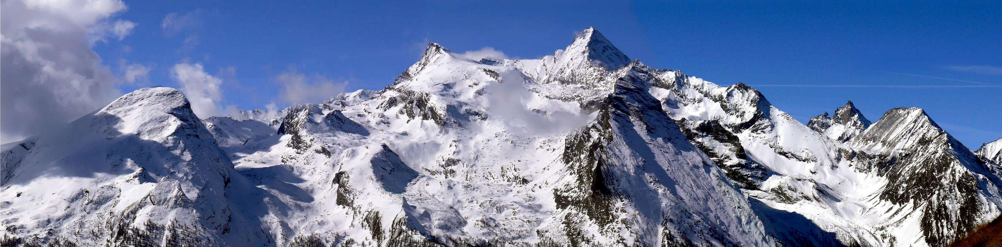
Mountain prominently at the base of the Northeast Ridge of Grivola (3.969m) or "Arête des Clochettes", even after they have formed the Grivoletta and the hill of the same name and the "Giacosa Crest" (3.514m, 3.322m, 3.416/3.323m). Dominates the underlying Colle del Traso or Trayo even Tradzo from which this buttress, after the tip of the same name, reaches the Pointe de Lavincusse (2.867m) and Bec D'Eytava or Dentavù (2.598m) just above the fraction of Epinel (1.436m), in Cogne Commune. It turns formed as asymmetric pyramid and disposed on the North / South axis with only two sides. What Eastern, triangular, steep and uneven, facing the Valley of even Traso or Tradzo below the Glacier du Mont Grivoletta, while the opposite or Western easier but complex and detailed, down to the Valley of Nomenon on the edge of Glacier du Mont Grivola This structure, apparently simple, it reveals rather complex and complicated to locate the same route, as transpires from the route of the first climbers forced to a fanciful and dangerous tour from the North Ridge to the Western Face, only to find that the easiest way is held on the opposite ridge or Southern. Which they did, while the second in 1893, four years after, solved the problem by going up in full for the North Ridge. A shareable choice, since it allows both the ascent from the Valley of Traso that from of Nomenon. For these reasons given above the mountain has fallen into "disuse" and almost completely abandoned by the Mountaineers. It requires more than great technical skills, the ability to know to identify the route. In addition the approaches to the Traso Pass they are quite long on both sides. Rewards of this effort a great view of the Northeastern Wall of the Grivola which stands directly opposite.
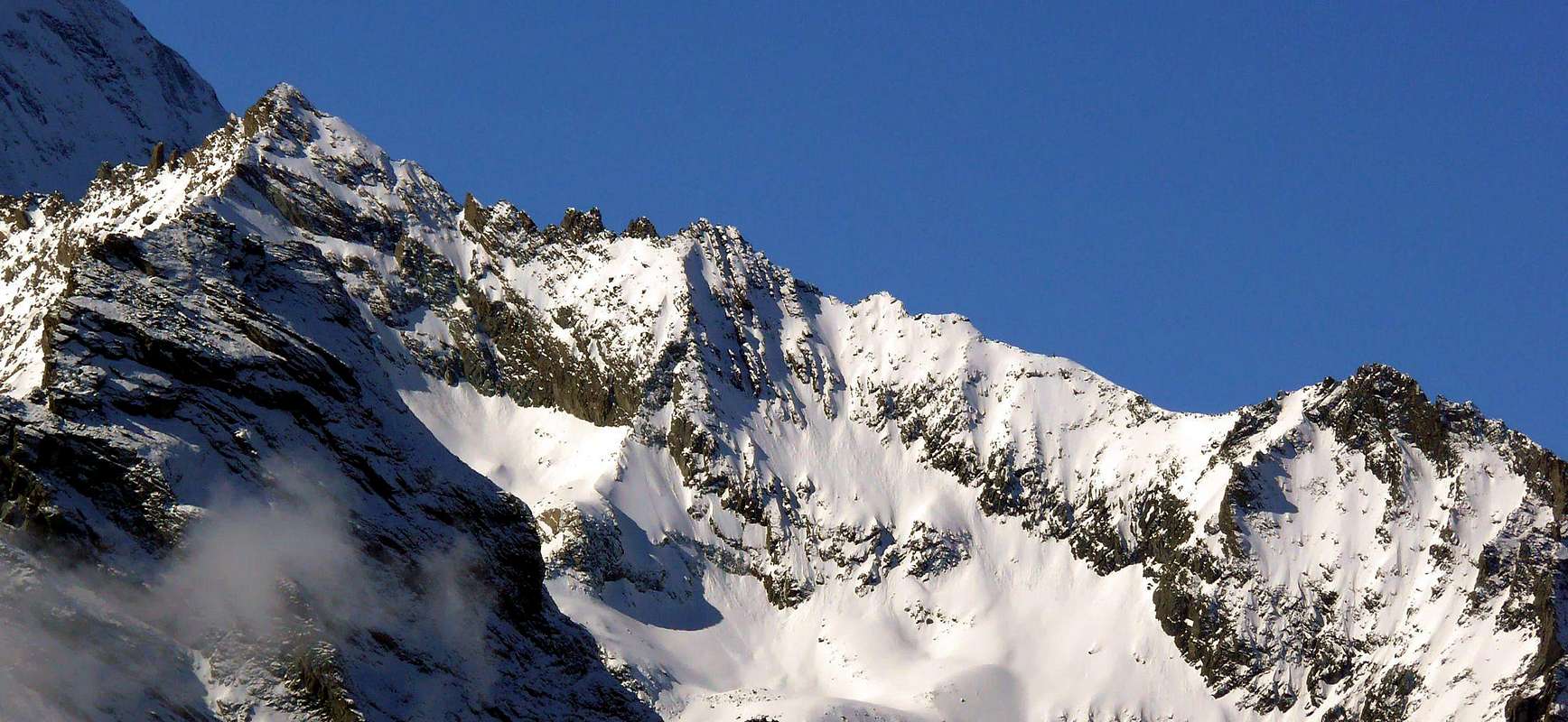 |
Montagna in bella evidenza alla base della Cresta Nordest della Grivola (3.969 m) od "Arête des Clochettes", subito dopo che questa ha formato la Grivoletta e l'omonimo colle e la "Cresta Giacosa" (3.514 m, 3.322 m, 3.416/3.323 m). Domina il sottostante Colle del Traso o Trayo ed anche Tradzo dal quale questo contrafforte, dopo la punta con lo stesso nome, raggiunge la Pointe de Lavincusse (2.867 m) ed il Bec D'Eytava o Dentavù (2.598 m) subito al di sopra di Epinel (1.436 m), Frazione di Cogne. Risulta formata a guisa di piramide asimmetrica e disposta sull'asse Sud/Nord con due soli versanti. Quello Orientale, triangolare, ripido ed uniforme, è rivolto verso il Vallone del Traso od anche Tradzo sottostante al Glacier du Mont Grivoletta, mentre l'opposto od Occidentale, più facile ma complesso ed articolato, scende verso il Vallone di Nomenon ai margini del Glacier du Mont Grivola. Questa struttura, apparentemente semplice, si rivela invece complessa e complicata per individuare la via di salita, come traspare dal percorso dei primi salitori costretti ad un fantasioso e pericoloso tour dalla Cresta Settentrionale alla Faccia Ovest, per poi scoprire che la via più semplice si svolge sulla cresta opposta o Meridionale. Cosa che fecero, mentre i secondi nel 1893, cioè quattro anni dopo, risolsero il problema salendo integralmente per la Cresta Nord. Una scelta condivisibile, poiché permette la salita sia dal vallone del Traso che da quello del Nomenon. Per questi suddetti motivi la montagna è caduta in "disuso" ed abbandonata quasi completamente da parte degli Alpinisti. Infatti richiede, più che grandi capacità tecniche, la capacità di saper individuare l'itinerario. Inoltre gli avvicinamenti al Colle del Traso sono alquanto lunghi su entrambi i lati. Ripaga di questa fatica una grande vista sulla parete Nordest della Grivola che si innalza proprio di fronte.
First Ascent
- First ascent (in the summit): W.B.A. Coolidge and F. Gardiner with Swiss Mountain Guides Christian Junior and Rudolf Almer, (Aug 21th, 1889).
- N Ridge: Georges Yeld with Valtournanche Mountain Guides François and Sylvain Pession, (Aug 27th, 1893).
- N Ridge and W Slope: W.B.A. Coolidge and F. Gardiner with Swiss Mountain Guides Christian Junior and Rudolf Almer, (Aug 21th, 1889), in ascent.
- W Face and S Ridge: W.B.A. Coolidge and F. Gardiner with Swiss Mountain Guides Christian Junior and Rudolf Almer, (Aug 21th, 1889), in descent.
- E Face and South Ridge: Osvaldo Cardellina and Marco Cossard, (Sep 09th, 1979), in ascent with descent by south Ridge and Eastern Slope.
- In winter: Unknown.
Getting There
BY CAR:
- From Torino, Milano, etc: Motorway A5. Exit at Aosta Ovest. Drive to the near Aymavilles. Follow the directions for Valle di Cogne.
- From Switzerland: through the Grand Saint Bernard Tunnel or the namesake Pass. Drive to Aosta, then follow the direction for Courmayeur on SS.26. Just after Sarre, turn to the left, in the direction of Valle di Cogne.
- From France: through Mont Blanc Tunnel or Petit St. Bernard Pass. It isn't necessary to take Motorway A5: you can drive on SS.26, in the direction of Aosta. Before arriving at the Village of Sarre, turn right following the sign for Valle di Cogne. After Aymavilles, the SR.47 crosses the Villages of Vieyes and Epinel (1.436m).
BY PLANE:
- Aeroporto "Corrado Gex" Saint Christophe (Aosta).
Approach and Route


From Epinel Hamlet (1.436m) goes up before towards the South: with the path n° 27/TVC, after in South-southwest towards Pianes (1.694m) Pastures reaching the following junction 1995 meters and the subsequent Trajo Alp (2.035m) (T/E/F; 1h'50/2h'00). From Alp always through the same path, but in West-southwest, to Casotto P.N.G.P. (2.155m) and, passing an easy rocky bend, towards the Trajo or Trayo Pass (2.873m) (EE/F+; 2h'15/2h'45). From the hill climbing in South through Northern Ridge, with some circumvention in West Face in final part, to Pointe Crevasse (3.303m) (A/F+/PD-; 2h'15/2h'30 from Traso Pass).
Dal Villaggio di Epinel Hamlet (1.436 m) risalire dapprima verso Sud tramite il sentiero n° 27/TVC, quindi in Sud-sudovest raggiungendo l'Alpeggio di Pianes (1.694 m) ed il successivo bivio 1.995 metri sino ad arrivare alla susseguente Alpe del Trajo (2.035 m) (T/E/F; 1h'50/2h'00). Dall'alpeggio sempre per mezzo dell'identico sentiero, ma con direzione Ovest-sudovest, arrivando al Casotto P.N.G.P. (2.155 m) ed, oltrepassata una facile fascia rocciosa, raggiungere il Colle del Trajo o Trayo (2.873 m) (EE/F+; 2h'15/2h'45). Dal medesimo arrampicando verso Sud sulla Cresta Settentrionale, con alcuni aggiramenti sul Versante Occidentale verso il termine, pervenire alla Punta Crevasse (3.303m) (A/F+/PD-; 2h'15/2h'30 dal Colle del Traso).
Difficulties
These routes can be considered A/F+ for the Southern Crest and A/PD-/PD+ for the Northern Ridge.Gli itinerari sono da classificare in A/F+ per la Cresta Sud ed A/PD-/PD+ per quella Nord.
Equipment
For Mountaineering with rope, ice-axe and crampons in snow presence.Da Alpinismo con corda, piccozza e ramponi in caso di presenza di neve.
MAPS:
Camping
- Wild camping in the Parco Nazionale del Gran Paradiso is strictly forbidden!!!
 |
Mountain Condition
- You can get weather forecasts at the official site of the Regione Valle d'Aosta:
- Valle d'Aosta Meteo
Webcam
- WEBCAM on Aosta Valley:
- Webcam
Books and Maps
BOOKS:- "Guida dei Monti d'Italia-Gran Paradiso Parco Nazionale" E. Andreis, R. Chabod, M. C. Santis, Club Alpino Italiano/Touring Club Italiano, prima Ed. 1939; seconda Ed. 1963; terza Ed. 1980.
- "Diari Alpinistici" di Osvaldo Cardellina e Indice Generale accompagnato da Schedario Relazioni Ascensioni 1964-2019 (inediti).
- "Guida delle Alpi Occidentali", di Giovanni Bobba e Luigi Vaccarone C.A.I. Sezione di Torino Volume II (parte II), 25 Maggio 1896.
- "Rifugi e bivacchi in Valle d'Aosta", di Cosimo Zappelli aggiornata da Pietro Giglio, Musumeci Editore, Luglio 2002.
 |
 |
 |
 |
- Kompass "Gran Paradiso Valle d'Aosta Sentieri e Rifugi" Carta Turistica 1:50.000.
- Enrico Editore Ivrea-Aosta "Gruppo del Gran Paradiso" 1:50.000.
- L'Escursionista "Valle di Cogne Carta dei Sentieri" 1:25.000.
- L'Escursionista "Tour de la Vallée de Cogne Grand Paradis" 1:25.000.
- I.G.C. Istituto Geografico Centrale "Parco Nazionale del Gran Paradiso" 1:50.000.
- Studio F.M.B. "Gran Paradiso" Bologna 1:50.000.
Important Information
- REGIONE AUTONOMA VALLE D'AOSTA the official site.
- FONDAZIONE MONTAGNA SICURA Villa Cameron, località Villard de la Palud n° 1 Courmayeur (AO) Tel: 39 0165 897602 - Fax: 39 0165 897647.
- SOCIETA' GUIDE ALPINE DI COGNE Tel. 347/9473526 – 328/1373728.
- A.I.NE.VA. (Associazione Interregionale Neve e Valanghe).
- A.IA.T. Cogne Gran Paradis via Bourgeois n° 34 Tel. 0165-74040. E-mail: aiat@cogne.org
- Ezio Sport articoli sportivi - via Bourgeois n° 64 Tel. 0165-74204.
Useful numbers
- Soccorso Alpino Cogne (SAR) Tel. 3482685406.
- Protezione Civile Valdostana località Aeroporto n° 7/A Saint Christophe (Ao) Tel. 0165-238222.
- Bollettino Meteo (weather info) Tel. 0165-44113.
- Bollettino Valanghe Tel. 0165-776300.
- Unità Operativa di Soccorso Sanitario Tel. 118.