
|
|
Mountain/Rock |
|---|---|
|
|
46.33241°N / 9.65999°E |
|
|
Mountaineering, Trad Climbing, Sport Climbing |
|
|
Spring, Summer, Fall |
|
|
9268 ft / 2825 m |
|
|
Overview
The Punta da l'Albigna is an easily recognizable summit on the eastern side of the Albigna lake in the Bergell, an area in south-eastern Switzerland famous for its multitude of alpine rock climbs on excellent granite. Along with the Spazzacaldeira and the Piz Balzet, the Punta da l'Albigna ranks among the most popular climbing hotspots in the Albigna area. It hosts numerous routes from 4a to 5c and varying in length between 8 and 12 ropelengths. Most of the routes are bolted, though some rather sparingly. Some skill with placing gear will be required. Access from the Albigna hut is straightfoward; a 45 minute walk places you at the start of the most popular routes. Depending on which route you climb, descent can involve some exposed downclimbing.

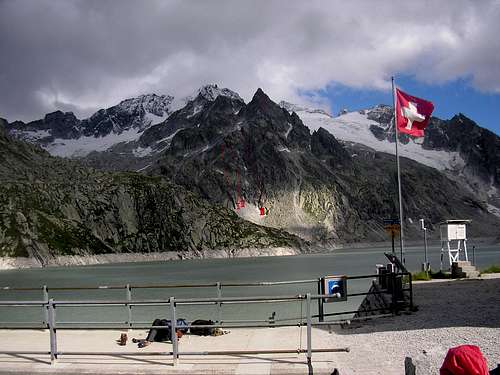
The Punta seen from the Albigna dam.
Getting There
The Punta da l'Albigna can be climbed from the Albigna hut located nearby but can also be done as a dayclimb using the cablecar which takes you up to the foot of the Albigna dam. Getting to the hut can be done by taking the same cablecar or by walking in from the valley. Both the walk-in and the cablecar start in a small place called Pranzaira below the Maloja pass, half an hours drive from the nearest large town St Moritz. There is plenty of room to park your car next to the cablecar station and this parking is free. A return ticket costs 18CHF which is approximately 12 euros. The walk in follows a well marked path of white-red-white markings and starts just along the road above the cablecar station. The path winds its way through pine forests to emerge just below the northern side of the Spazzacaldeira and it takes 2 - 3 hours to reach the cablecar station at the foot of the Albgina dam. From the cablecarstation at the foot of the dam take the obvious path up and over the dam and make your way along another well marked (white-red-white) path towards the Albigna hut. This takes another 40 minutes or so. From the Albigna take a well-trodden path that leads down and in a southernly direction. Follow an old waterpipe, cross a stream and make your way across a boulder field to the start of the routes. Approximately 30 - 45 minutes.
Routes
The Punta da l'Albigna sports a host of routes, a complete overview of which can be found in the Swiss Alpine Club guidebook 'Sudliches Bergell'. For a selection of the best or in any case most popular routes on the mountain, the guidebook 'Schweiz Plaisir Sud' comes highly recommended. All these routes are on the north-west side of the mountain and therefore do not see much sun.
Some popular routes are: 1) 'Moderne Zeiten', 5a 2) 'Via Meuli', 4b 3) 'Via Steiger', 4c - 5c
None of these routes lead directly to the top, instead they finish just below the obvious ridge seen in the photographs. Crossing this ridge by scrambling through a large gully cleary visible once you finish the routes brings you to a large field of rubble which can be either followed upwards towards where the last pitches to the summit start, or walked down to leave the mountain. Please keep in mind that the picture provided below is only meant to give a general idea of the direction the routes follow.
ENLARGE IMAGE FOR ROUTES OVERVIEW
Routes overview
Red Tape
None.
Camping
The campsite nearest to the cablecar station and the footpath leading up to the Albigna area is called camping Mulina and is located just outside of the small town of Vicosoprano, a mere five minutes drive from the cablecar station. Camping or bivouacing in the mountains is forbidden in the Bergell as it is everywhere in Switzerland. There are however several very good locations in and around the cablecar station at the foot of the dam.
External Links
The Albigna hut Camping Mulina
Guidebooks and maps
Jürg von Känel, Schweiz Plaisir Sud (Edition Filidor 2003). Ruedi Meier and Peter Alig, SAC-führer Bündner Alpen 4: Südliches Bergell - Disgrazia (SAC Verlag 2006). British Alpine Club guidebook 'Bergell and Bernina'
Map: Swisstopo 1:25000 #1296 'Sciora'.
Remco Woutersen - Mar 1, 2007 11:38 am - Hasn't voted
Some reading.For the route there are (at least) two very nice books. The best is in Jürg von Känel's great Plaisir series (he will be missed): Schweizer Plaisir Süd Jürg von Känel ISBN: 3906087115 Year: 2000 This book is concerned with bolted alpine sports climbing in the southern part of Switserland. The text is in german, french and italian, but most information is very clear from the pictures. And ofcourse you can always use the SAC-führer, which came out again in 2006: SAC-führer Bündner Alpen 4 Südliches Bergell - Disgrazia Ruedi Meier / Peter Alig I only know the older version of this book personally. It contains information on the rock climbing as well as on alpine routes and huts in the area and is by far the most complete guide.