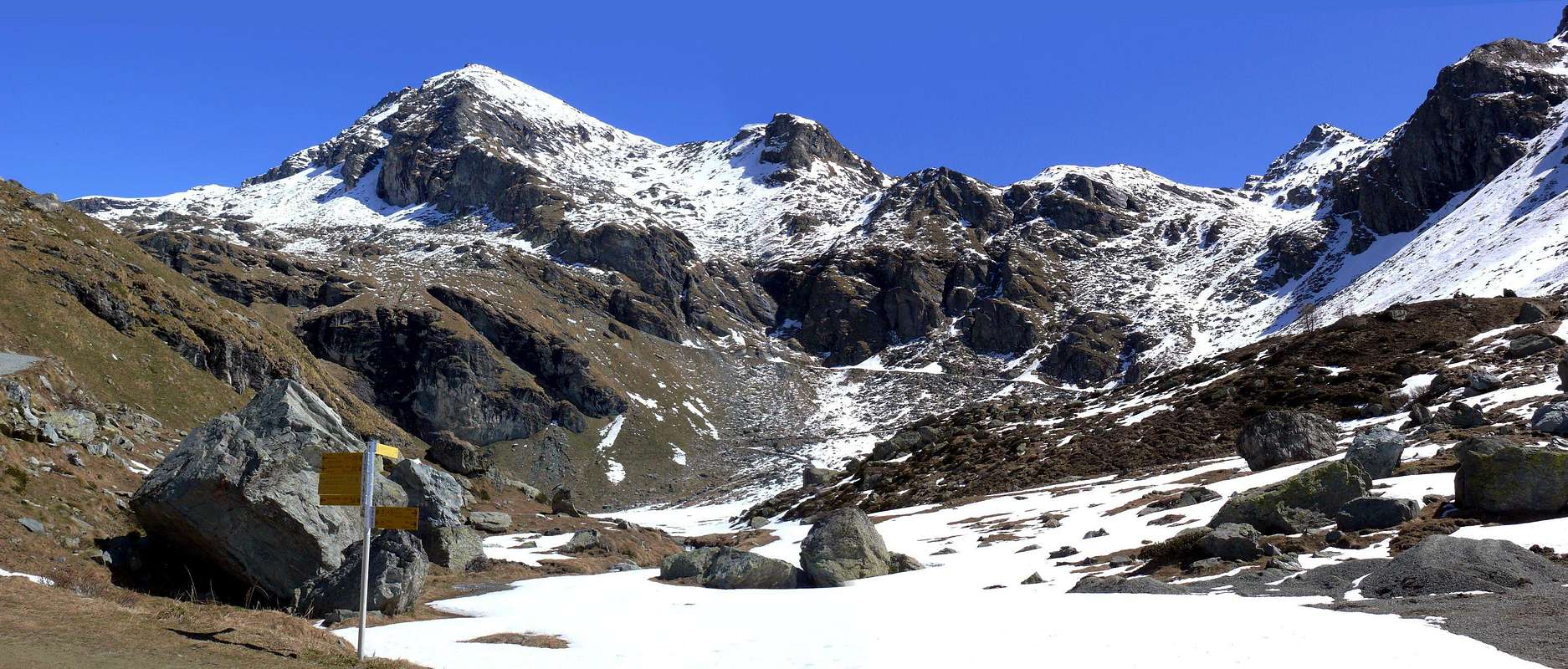
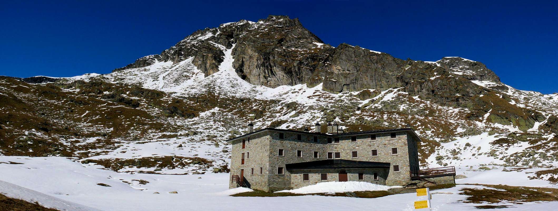
This Summit, known in place even as or Freidòhòre, between the Valleys of Ayas and Lys or Gressoney is located more precisely near the top of the Northeast Basin Palasina and counterbalanced on the other side from the Corno Bussola (Horn Compass; (3.023m). A ridge connecting the two, interrupted by the Punta Palasina (2.782m) and from that of the Lake (2.816m), separating this basin from the Vallon of Mascognaz immediately to the North. His Southern Ridge instead be directed towards Colle di Valnera or Valdònierfòrkò (2.673/6m), small incision between Palasina and Val Nera into the Lys Valley, before the homonymous Punta (2.754m) on the same watershed which it relaxes towards South on adjacent Vallon Lakes Estoul just above the homonymous Hamlet, always above the same area. Just below is the recent Arp Refuge (2.446m), reached by a private dirt farms road or through paths starting in each case from the same village. This can be useful as a base, even though the climb is feasible in the day, turning to the East before the last ramp on the road that joins him and near the previous junction 2.231 meters. Formed by two ridges and as many sides the second of which is divided into two parts: a small wall, but enough steep and complex, facing West-northwest over the shelter separated by an edge-small crest from wider and easier Slope Southwest. The other ridge or North, short but not entirely easy and formed by various elevations, falls towards Valfredda Pass (2.805m), extreme passage between the three Lakes Valfredda into Palasina Basin and the Valfredda Valley above the Alpenzù (1.779m) in Gressoney Valley. The rock quality is not good, often crumbling or covered with layers of grass, should stay on the ridges, among which we recommend the easier and safer of Southwest, or on the just adjacent slope always Southwest. Also known as Punta Lavassey in locality of Brusson and as the Corno (Horn) of Valnera in Gressoney Valleys, it offers sweeping views of the two valleys up to the two Lyskamms, the whole Monte Rosa Group and the nearby more known Testa Grigia (Grey Head; 3.314m).
Questa Cima, conosciuta in loco anche come Freidòhòre, tra le Valli di Ayas e del Lys o Gressoney si trova collocata più precisamente quasi al vertice Nordest della Conca di Palasina e controbilanciata sul lato opposto dal Corno Bussola (3.023 m). Una cresta unisce le due, interrotta dalla Punta di Palasina (2.782 m) e da quella del Lago (2.816 m), separando questo bacino dal Vallone di Mascognaz immediatamente a Settentrione. La sua Cresta Sud invece si indirizza al Colle di Valnera o Valdònierfòrkò (2.673/6 m), piccola incisione tra Palasina e la Val Nera in Valle del Lys, precedente sullo stesso spartiacque l'omonima Punta (2.754 m) a Meridione della quale si distende il Vallone adiacente dei Laghi di Estoul, sempre al di sopra del medesimo comprensorio. Appena al di sotto si trova il recente Rifugio Arp (2.446 m), raggiungibile con una strada poderale privata oppure tramite sentieri partendo in ogni caso dallo stesso villaggio; questo può risultare utile come punto di appoggio, anche se l'ascensione risulta fattibile in giornata volgendo ad Oriente prima dell'ultima rampa stradale che lo raggiunge e nelle vicinanze del precedente bivio 2.231 metri. Formata da due creste ed altrettanti versanti il secondo dei quali viene suddiviso in due parti: una piccola parete, ma abbastanza ripida e complessa, rivolta ad Ovest-nordovest sopra il rifugio separata da uno spigolo-crestina dal più largo e facile Versante Sudovest. L'altra cresta o Nord, breve ma non del tutto facile con diverse asperità, scende verso il Passo di Valfredda (2.805 m), estremo passaggio tra i tre Laghi di Valfredda nella Conca di Palasina ed il Vallone di Valfredda sopra l'Alpenzù (1.779 m) in Valle di Gressoney. La non buona qualità della roccia, spesso sgretolata o ricoperta da strati erbosi, consiglia di restare sulle creste, tra le quali è consigliabile la più facile e sicura Sudovest, oppure sull'adiacente Versante Sudovest. Conosciuta anche come Punta di Lavassey in tutta la località di Brusson e come Corno di Valnera in Valle di Gressoney, presenta ampie vedute sulle due valli fino ai Lyskamm ed al Monte Rosa, nonché sulla vicina e maggiormente conosciuta Testa Grigia (3.314 m).
First Ascents
First on the Summit: Unknown.
In winter: Unknown.
Southeastern Ridge (Normal Route): Unknown.
Southwestern Edge: Osvaldo Cardellina and Marco Cossard, Jul 03th, 1978, in ascent with descent through Southwest Slope.
West-northwest Face Osvaldo Cardellina, lone, Jul 06th, 1980, in ascent with descent through N-NW Crest to carving 2811 meters.
North-northwest Crest: Osvaldo Cardellina, lone, Jul 06th, 1980, in descent. Osvaldo Cardellina and Emilio Bertona, Sep 09th, 2001, with traverse from Corno Vitello.
Getting There
BY CAR:
From TORINO, MILANO, etc: Motorway A5. Exit at IVREA or Quincinetto (PIEDMONT).
From IVREA Town: in West (Southern side) to Pont Saint Martin, Verrès Municipalities in East from Aosta Town.
From Courmayeur Resort: in East-southeast to Aosta, Nus, Chatillon, Saint Vincent, Verrès Municipalities.
BY PLANE:
Aeroporto "Corrado Gex" Saint Christophe (Aosta).
Approach and Route
Approach through Palasinaz Vallon: from Brusson Commune to Estoul Village (+; 1.818m; great parking; panels and variaous signals) with the Regional Road; from this, in North through dirt road concomitant with the trail n° 5, towards Fenillettaz Pastures (1.840m), following alternative (1.882m; signal no transit for unauthorized means), Fontaine (1.903m), Chanlochère (2.012m), fork 2.029 meters, Chavanne (2.107m) Alpages, alternatives 2.103, 2.209 meters nearby Litteran Lake (2.226m), fork 2.231 meters. From the latter, leaving left the farm dirt road that goes towards the above Arp Refuge (2.446m), to the East-northeast instead follow the trail n° 5D/105 that reaches the Colle Valnera or Valdònierfòrkò (2.673/6m) between Valfredda and Valnera Summits. This, via the Southeast Ridge easy with some small rocks in the final, reaching the Summit (EE/F;3h'15/3h'45 from the beginning of dirt road nearby Estoul Village).
Avvicinamento dal Vallone dal Vallone di Palasina: dal Villaggio di Estoul (1.818 m; grande parcheggio con pannelli con segnalazioni varie) dapprima verso Nordovest poi Nord tramite la Strada Regionale; dal villaggio, con direzione a Settentrione per mezzo della poderale concomitante al sentiero n° 5, in direzione degli Alpeggi di Fenillettaz (1.840 m), successivo bivio (1.882 m; segnale di divieto al transito per i mezzi non autorizzati), e le successive Alpi di Fontaine (1.903 m), Chanlochère (2.012 m), bivio 2.029 metri, Chavanne (2.107 m), biforcazioni 2.103, 2.209 metri nelle vicinanze del Lago Litteran (2.226 m), seguente bivio 2.231 metri. Da quest'ultimo, lasciata a sinistra la strada poderale che prosegue verso il soprastante Rifugio Arp (2.446 m), seguire invece una piccola traccia presso il torrentello verso Est-nordest fino al sentiero n° 5D/105 che raggiunge il Colle di Valnera o Valdònierfòrkò (2.673/6 m) collocato tra le Punte di Valfredda e di Valnera; da questo, tramite la facile Cresta Sudest con percorso semicircolare e qualche roccetta finale, raggiungere la Cima (EE/F; 3h'15/3h'45 dall'inizio della poderale presso il Villaggio di Estoul).
Parents refers to a larger category under which an object falls. For example, theAconcagua mountain page has the 'Aconcagua Group' and the 'Seven Summits' asparents and is a parent itself to many routes, photos, and Trip Reports.

 1907 Hits
 82.48% Score
 15 Votes