
-
 1087 Hits
-
 83.1% Score
-
 16 Votes
|
|
Mountain/Rock |
|---|---|
|
|
45.80733°N / 7.77255°E |
|
|
Hiking |
|
|
9757 ft / 2974 m |
|
|
Overview
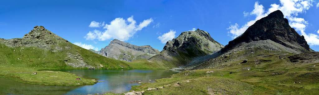
Small peak that rises between the Vallone di Cuneaz to the north and that of Mascognaz to the opposite, both located immediately southeast of the Municipality of Champoluc (1.568m) in the Ayas Valley. It is also located southeast of the homonymous hill (2.649m) and lake (2.689m) located at the foot of the border ridge with the Gressoney Valley, exactly between Colle Pinter (2.776m) at the foot of Testa Grigia (3.316m; Grey Head) and Colle di Mascognaz (2.861m) at the foot of Corno Vitello (3.057m; Calf Horn). Summit not very busy and of hiking interest, has recently become also a ski-mountaineering destination in general by combining, starting from the collar about 2.900 meters and also known as Colle della Gran Cima,the same with that of the nearby precisely Gran Cima (3.023m) and with the possibility of descent also to Gressoney La Trinité Municipality (1.648m; BSA, or Good Skiers Mountaineers).
Piccola cima che s'eleva tra il Vallone di Cuneaz a Nord e quello di Mascognaz all'opposto, entrambi posti subito a Sudest del Comune di Champoluc (1.568 m) in Valle d'Ayas. Inoltre si trova a Sudest degli omonimi colle (2.649 m) e il lago (2.689 m) posti ai piedi della cresta di confine con la Valle di Gressoney, esattamente tra il Colle Pinter (2.776 m) ai piedi della Testa Grigia (3.316 m) ed il Colle di Mascognaz (2.861 m) alle falde del Corno Vitello (3.057 m). Sommità non molto frequentata e di interesse escursionistico, é diventata negli ultimi tempi anche meta di sci-alpinismo in genere abbinando, partendo dal colletto 2.900 metri circa nonché conosciuto anche come Colle della Gran Cima, la medesima con quella alla vicina Gran Cima (3.023 m) e con possibilità di discesa anche a Gressoney La Trinité (1.648 m; BSA, ovvero Buon Sciatori Alpinisti).
First Ascents
First in the Summit: Unknown.
In winter: Unknown.
Getting There
Getting in Gressoney Saint Jean or Gressoney La Trinitè or Champoluc
- From Torino or Milan: Motorway A5, exit in Pont Saint Martin. Follow Val di Gressoney direction or alternatively exit Verrès and follow the Val d'Ayas direction.
- From Switzerland (Tunnel or Grand Saint Bernard Pass): in Aosta Est, get into Motorway A5. Follow Torino direction, exit from A5 in Pont Saint Martin, follow Val di Gressoney direction or alternatively exit Verrès and follow the Val d'Ayas direction.
- From France (Tunnel Mont Blanc or Petit Saint Bernard Pass): get into Motorway A5, follow Torino direction, exit from A5 in Pont Saint Martin, tell a couple of bad words to the man in the box for the huge motorway fee, and follow for Val di Gressoney direction or alternatively exit Verrès and follow the Val d'Ayas direction.
- Route 1, "La diretta". Park the car in Gressoney la Trinitè, and look for a shop called "Alimentari Welf". Very close to this shop there is the headtrail.
- Route 2, "Ondre Castel, Pinter", Gressoney Saint Jean. At Km 31 of Val di Gressoney Road, there is a little park, close to a garbage collector. 50 meters under this little parking there is headtrail ("Colle Pinter" indication on yellow panel). It is possible to begin this route from Chamonal village (km 28,8 of Val di Gressoney road). It's a little big longer, but a visit to the typical village of Alpenzu Grande (1.779m) will satisfy your curiosity for old Walser architecture. People interested in Champoluc destination, follow the same instruction as before changing Pont Saint Martin with Verres (exit from A5), and follow Val d'Ayas direction.
Approach
From Champoluc Municipality you can reach the Ostafa cable car station with the path n° 13, or using the cable car. Go down briefly to take the path n° 12. Follow the path winding along the slope with moderate ascent and finally reach the Alta Via n° 1 just before the detour to the right to the Pinter Lakes. At an altitude of about 2.715 meters, leave the Alta Via and turn right (South) to take a small path that with a long diagonal more towards the Southwest reaches first the Lacs de Pénté (2.689m; Pinter Lakes) and then, with a modest descent, Lake Perrin (2.633m) just below the homonymous hill (2.649m; here you can also reach it with a previous deviation at an altitude of 2.160 meters around which, via trail n° 13, passes towards Alpe Pian Long 2.179 meters).
Da Champoluc si può raggiungere la stazione della funivia Ostafa con il sentiero n° 13, o utilizzando la funivia. Scendere brevemente per prendere il sentiero n° 12. Seguire il sentiero che si snoda lungo il pendio con moderata salita e raggiungere infine l'Alta Via n° 1 poco prima della deviazione a destra per i Laghi di Pinter. A quota 2.715 metri circa abbandonare l'Alta Via, e piegando a destra (Sud) prendere un sentierucolo che con lungo diagonale maggiormente verso Sudovest raggiunge dapprima i Lacs de Pénté (2.689 m; Laghi Pinter) e poi, con modesta discesa, il Lago Perrin (2.633 m) appena al di sotto dello omonimo colle (2.649 m; qui si giunge anche con una precedente deviazione a quota 2.160 metri che tramite il sentiero n° 13, passa verso l'Alpe Pian Long 2.179 metri).
Route
From Colle Perrin or from the underlying lake, you cross, on slender traces facing East, the latter crossing the small valley between Mount Perrin and the various altitudes of the Northwestern Ridge of Corno Vitello, that is, between the Gran Cima (3.023m) to the North. and Mount Perrin to the West-southwest, reaching the col of about 2.900 meters or Colle della Gran Cima (actually there is a lower notch at an altitude of 2.874 meters). Climbing easily in the midst of stony ground alternating with some rocky slabs, encountering some cairns or modest and scattered stone trail markers, and from last through an elementary grass hump you reach in succession the tiny antesummit and the Summit (EE; 3h'00. from Crest or from the connection with the next Mascognaz Hamlet; 4h'00/4h'15 from Champoluc).
Dal Colle Perrin oppure dal sottostante lago si oltrepassa, su esili tracce rivolte ad Oriente, questo ultimo percorrendo il piccolo vallone cmpreso tra il Monte Perrin e le varie altitudini della Cresta Nordovest del Corno Vitello, cioé tra la Gran Cima (3.023 m) a Nord ed il Monte Perrin ad Ovest-sudovest, raggiungendo il colletto 2.900 metri circa o Colle della Gran Cima (in realtà esiste un intaglio più basso a quota 2.874 metri). Salendo facilmente in mezzo a pietraie alternate ad alcuni lastroni rocciosi, incontrando alcuni ometti o modesti e sparsi segnavia in pietra, e da utimo tramite un elementare dosso prativo si raggiungono in successione l'antecima minuscola e la Sommità (EE; 3h'00 dal Crest o dal collegamento con il vicino Villaggio di Mascognaz; 4h'00/4h'15 da Champoluc).
Difficulty
For Hiking with experience also or good skiers-mountaneers (BSA).
Da Escursionismo esperto (EE) oppure BSA (buoni sciatori-alpinisti).
Gear
For Hiking or by ski.
Da Escursionismo oppure con sci.
Campings
Remember that free camping is forbidden (except for emergency reasons, over 2.500m, from darkness until dawn).
Mountain Conditions
- You can get meteo information at the official site of the Regione Valle d'Aosta:
- Valle d'Aosta Meteo
- Meteo: You can find more weather information on the website 3B Meteo:
- Meteo Brusson
Webcam
- WEBCAM on Aosta Valley:
- Webcam
Books and Maps
BOOKS:
- "Guida delle Alpi Occidentali" di Giovanni Bobba e Luigi Vaccarone C.A.I. Sezione di Torino Volume II (parte II), 25 Maggio 1896.
- "Diari Alpinistici" di Osvaldo Cardellina e Indice Generale accompagnato da Schedario Relazioni Ascensioni 1964-2019 (unpublished).
- "Guida dei Monti d'Italia" Alpi Pennine (Vol.2) di Gino Buscaini - Club Alpino Italiano/Turing Club Italiano, Luglio 1970 (In Italian).
 |
 |
 |
MAPS:
- I.G.C. Istituto Geografico Centrale Torino "IVREA-BIELLA e Bassa Valle d'Aosta" 1:50.000.
- I.G.C. Istituto Geografico Centrale Torino "Cervino e Monte Rosa" 1:50.000.
- L'Escursionista editore "Alte Valli d'Ayas e del Lys" Carta dei sentieri (8) 1:25.000.
Important Information
- REGIONE AUTONOMA VALLE D'AOSTA the official site.
- FONDAZIONE MONTAGNA SICURA Villa Cameron, località Villard de la Palud n° 1 Courmayeur (AO) Tel: 39 0165 897602 - Fax: 39 0165 897647.
- A.I.NE.VA. (Associazione Interregionale Neve e Valanghe).
Useful numbers
- Protezione Civile Valdostana località Aeroporto n° 7/A Saint Christophe (Ao) Tel. 0165-238222.
- Bollettino Meteo (weather info) Tel. 0165-44113.
- Unità Operativa di Soccorso Sanitario Tel. 118.
Acknowledgements
I am greatly indebted to my friend "Osva" for the detailed description of the route and translation into English.