
-
 11411 Hits
-
 86.86% Score
-
 24 Votes
|
|
Mountain/Rock |
|---|---|
|
|
44.68907°N / 7.07534°E |
|
|
Piemonte/Queyras |
|
|
Mountaineering, Trad Climbing, Sport Climbing |
|
|
Summer |
|
|
10072 ft / 3070 m |
|
|
Overview
Punta Roma 3069 m
Punta Roma 3069 m is a massive peak standing out onthe main watershed on Italy-France border, between Po valley and Guil Valley, and belonging to the Alpi Cozie. It's one of the best known mountains in the Monviso Group. The mountain has fairly steep faces on both the Western and the Eastern sides. The West face is more regular and it's situated in France; it's a wide wall and here we find the most difficult routes. The Eastern one is very jagged and divided in two sectors by the North-East ridge.
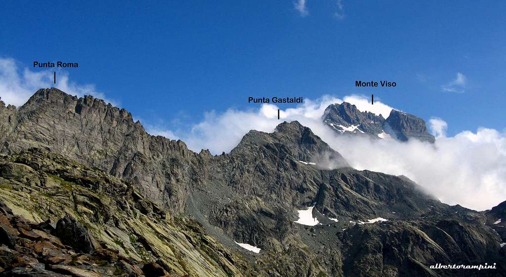

To the North the summit ridge descends slightly and continues towards the nearby Punta Udine; to the South the crest descends significantly to the Colonnello Pass, continues roughly up to Passo Giacoletti and then leads to Punta Gastaldi. The summit offers an awesome panoramic view of the Monviso North face. Punta Roma has a lot of interesting routes; the hardest ones are located on the shady and large West face on the French side.
The first ascent of the mountain was carried out by Ubaldo Valbusa on 29 August 1905 with the guide Claudio Perotti along the normal route. The same attributed the name "Punta Roma" to the mountain.

|

|
Getting There
Italian side: From Torino to Saluzzo (56 km from Torino), here take the Po Valley reaching Paesana, Crissolo and Pian del Re 2020 m, where the road ends. Here it's situated the spring of the Po river, that is the longest river in Italy.
French side: From Guillestre follow the road D902 towards Queyras. Otherwise you can approach from Briancon via the Izoard Col, reaching Chateau Queyras, Abries and Ristolas; from Ristolas take an unsurfaced road leading to Roche Ecroulèe parking m. 1787. The acces by car is not allowed after Roche Ecroulèe.


Huts approach
Rifugio Giacoletti (italian side) - From Pian del Re 2020 m take the good path (signs GTA, V16) to the Colle delle Traversette in the NW direction. Once at the entrance of the Vallone delle Traversette, turn left on the path V17, which goes up under the Rocce Alte del Losas and reaches the suggestive Lago Superiore 2313 m. The itinerary runs along the eastern shore of the lake and flows into the V14 trail. Continue on the right and at a second crossroads to Passo del Colonnello (V18) continue always to the right and passing under the wall of Punta Roma reach the refuge Vitale Giacoletti 2741 m (about 2 hours from Pian del Re). From Pian del Re several other itineraries are possible to reach the refuge, even more direct than the one described above.
Refuge du Viso (French side) - From Roche Ecroulèe follow by walk the road to Belvedere du Viso m. 2133. From here follow the path rising towards East until a crossroad at 2437 m, where you must turn to right following a mainly level path towards the almost well visible refuge (2 hours and 45 minutes from Roche Ecroulèe).
Punta Roma Normal route from Pian del Re


Normal Route report
Summit altitude: 3070 m
Difficulty: walking and easy climb
Difference in level: 1050 m from Pian del Re
Exposure: East
Starting point: Pian del Re 2020 m
A very interesting and panoramic route in view of the stunning Monte Viso


Approach: from Pian del Re go up after the Po sources to the Fiorenza lake (path to the Refuge Quintino Sella). After passing the first slope with numerous hairpins, the path touches the Lago Fiorenza and continues which with a wide-circle in view of Lago Chiaretto. Near this you ignore the trail that continues towards the Rifugio Quintino Sella, and turn to right onto the beautiful path to Rifugio Giaceoletti. Follow it uphill on a plateau and then cross from left to right (Punta Roma is above you), reaching the junction to Rifugio Giacoletti on the right and Punta Roma - Passo del Colonnello - Passo Giacoletti on the left. To climb Punta Roma follow the trail on the left, which cuts the slope below the rocky ramparts halfway up the slope, and then continues to climb up through meadows and some rocks with some hairpins, getting the last junction with a signpost, which on the right indicates the start of Punta Roma normal at an altitude of about 2800 m
Route description
The climb starts with a gully equipped with a fixed rope, then it continues to rise alternating walking sections to easy climb (rocks of I and II UIAA degree), in addition to the aforementioned gully there are two other jumps of rock.Still some easy climbing steps and we are at the top The climb is fun and not difficult, but do not underestimate it, the difference in level if you climb the mountain directly from Pian del Re is more than 1000 meters. If you want to take it easier you can stay overnight at the Refuge Giacolett and climb the route the day after.


Descent: reversing the route
Essential gear
For the Normal route helmet is strongly required, rope and harness are useful if you climb with beginners
Other routes
Punta Roma is rich of other interesting routes. On the italian side:
- South Ridge, difficulty II
- North-East, difficulty II - III
- Via Diretta o dei Pinerolesi, difficulty max IV+
- Via Allibert, difficulty max V
- Via dello Sperone di Destra, difficulty max IV
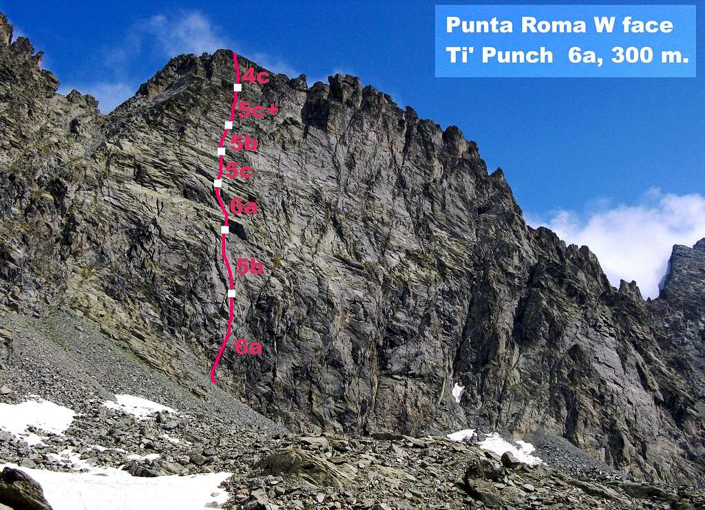
In the French side we find two nice routes running on the shady West wall, than can be approached from both the sides:
- Trois Rivières difficulty 4c, 300 m
- Ti' Punch difficulty 6a, 300 m


Approach from the Refuge du Viso - Don’t take the path heading towards SSE to Valant Col, but follow a less obvious track heading to East as far as Porcieroles Lake. From the lake don’t carry on towards Porco Gully, but turn to right rising along slabs and stones heading to the obvious high serrated W face of Punta Roma. Starting point is on the left-hand side of the face; last route on the left is “Trois Rivieres”. Ti’ Punch start about 60 mt. on the right of “Trois Rivieres” and on the left of a great steep black zone, rising along some easy steps just below a white quartz intrusion.
Approach from the Refuge Giacoletti (longer) - Follow the Porc Gully (Coulour del Porco) and the Via ferrata, reaching the Colle del Coulour del Porco. Go down in the opposite side to the Porcieroles Lake. From here join the previous approach.
Red Tape
No fees no permits required.
- Winter closure of the Pian del Re road
- The access by car is not allowed after Roche Ecroulèe
Huts


- Rifugio Giacoletti 2741 m - CAI (Italian Alpine Club- Barge), guardian Andrea Sorbino, open from 15-6 to 15-9
- Refuge du Viso 2460m - CAF (French Alpine Club - Briancon), guardian J. Bellier-Fouchard, open from15-6 to 15-9
When to climb
Generally it's possible to climb from June to September - October, depending on the presence of snow.
Meteo
- Meteo ARPA Regione Piemonte
- Meteo France
Guidebooks and maps
Guidebooks


“Monte Viso – Alpi Cozie Meridionali” by Michelangelo Bruno – Collana CAI-TCI Guide dei Monti d’Italia “Pays du Viso –Escalade en Queyras entre France et Italie” by Sylvain Pusnel and Guillaume Vallot
Maps
"Monviso-Valle Varaita-Valle Po-Valle Pellice" -IGC sheet 106 1:25000