
|
|
Route |
|---|---|
|
|
39.35140°N / 106.1108°W |
|
|
Snow Climb / Ski Descent |
|
|
Half a day |
|
|
Intermediate Backcountry Ski |
|
|
Introduction
Putnam Gulch is a relatively unknown Mosquito Range ski descent. This is surprising considering that the entire route is visible from CO 9.
This ski descent is a great intermediate route with high access year round. In good conditions, you can ski almost 3,000' feet from the summit on a continuous line.
Approach
Quartzville Creek Trailhead: 11,390 feet
From the North:
From Hoosier Pass on CO 9, descend 3.7 miles to the bottom of the valley and turn west onto Park County 4.
From the South:
From the intersection of US 285 and CO 9 in Fairplay, continue 8.1 miles to the turn to the west on Park County 4.
Turn west onto Park County 4. Set your odometer.
- Go west (left) at .1 mile
- Go south (left) at 0.3 mile
- Right at .4 mile
- Stay Right on the Quartzville Road at 2.7 miles
- Turn left onto FS 437 at 3.3 miles
- Follow FS 437 as far as you can go.
Red Tape:
FS 437 is a 4x4 road, and the only authorized parking is at a large parking area at the end of the road, approximately 1 mile from the turn. In winter, this road is never plowed, and it stays snowed in until May or June. There are no parking signs all along the main road and along the FS road. So, technically, parking is never allowed along the FS road, even when it is snowed in. However, parking is authorized at the end of an FS road as long as it is snowed in and no vehicle could conceivably drive further. Use your judgement here. Don't park on the main road.
 |
Route Description
This ski route is near the east slopes route that begins at Quartzville Creek TH. Typically, this line will give you the best ski descent in early Spring. This route does melt out quickly, so jump on it when it's good. To preview this entire route, drive up to Hoosier Pass, but park in one of the parking areas below the actual Hoosier summit. You can check the entire route from here. If you are interested in an easy snow climb, this route might also be a great choice for winter or spring.
This route is not recommended in dry conditions, or as a summer route. Please stay on the main East Ridge Route or the West Ridge Route to prevent erosion and to avoid creating more social trails here.
From the trailhead:
Skin or climb the remainder of FS 437. When FS 437 arrives at the parking area, bushwhack north under a large slope to the beginning of Putnam Gulch. Typically, you will be able to skin from here to the summit. Follow Putnam Gulch with variations to avoid avalanche slopes and bare ground.
Ski Descent:
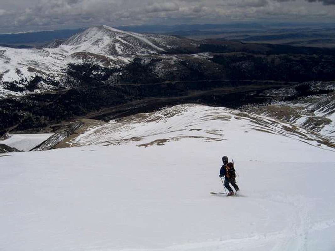
The terrain from the summit to the top of Putnam Gulch is an Intermediate slope. It is usually possible to ski right off the summit, down the summit pinnacle, and ski some of the upper slopes. This will be the most difficult part of the ski. Beginners may want to cache their skis below the summit pinnacle.
Upper Putnam Gulch is generally intermediate until you arrive at the lower section. The lower section is beginner terrain in a low-angled gully that is usually a pleasure to ski.
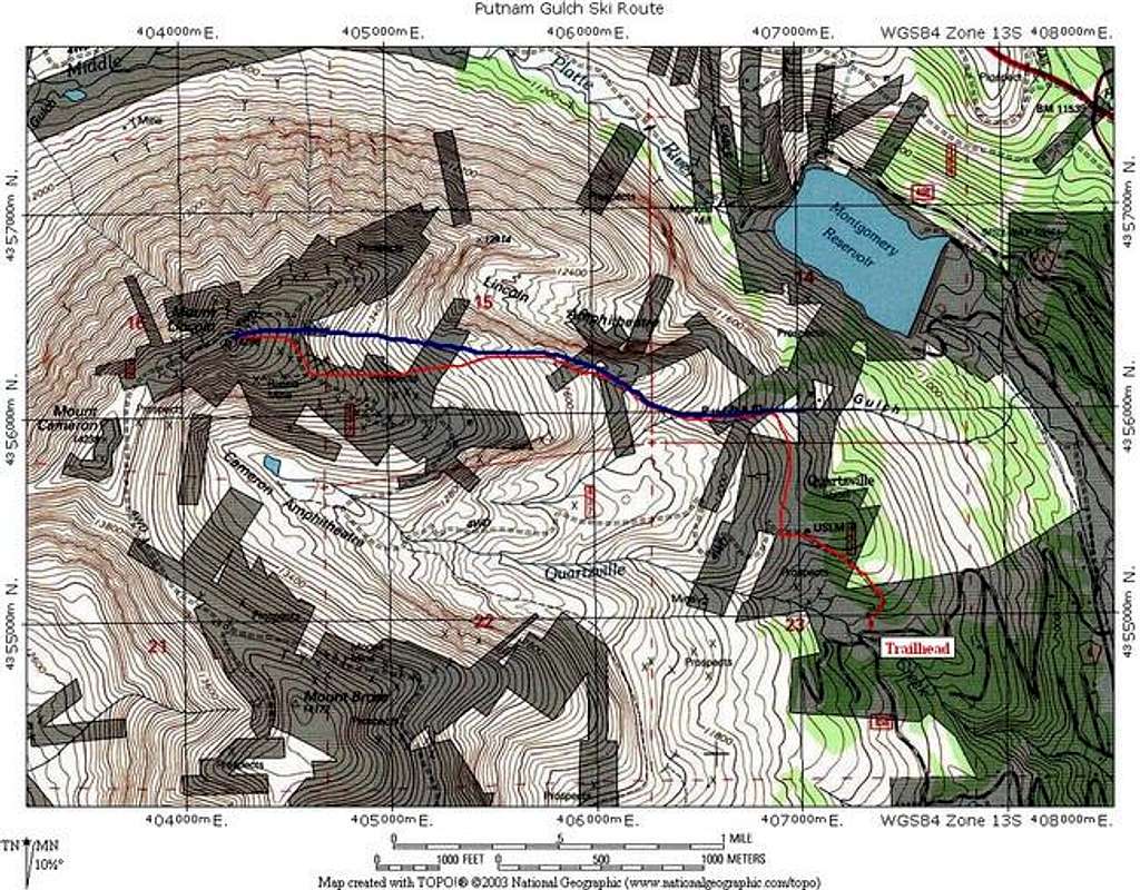
Refer to accompanying photos below and the TOPO map for an idea of the route.
On your descent, take care not to descend too far into Putnam Gulch. This will take you well below your traverse back to the FS road, and possibly drop you into private property. Use your altimeter and map.
Round Trip Mileage: 5.4 miles
Elevation Gain: 3,100 feet
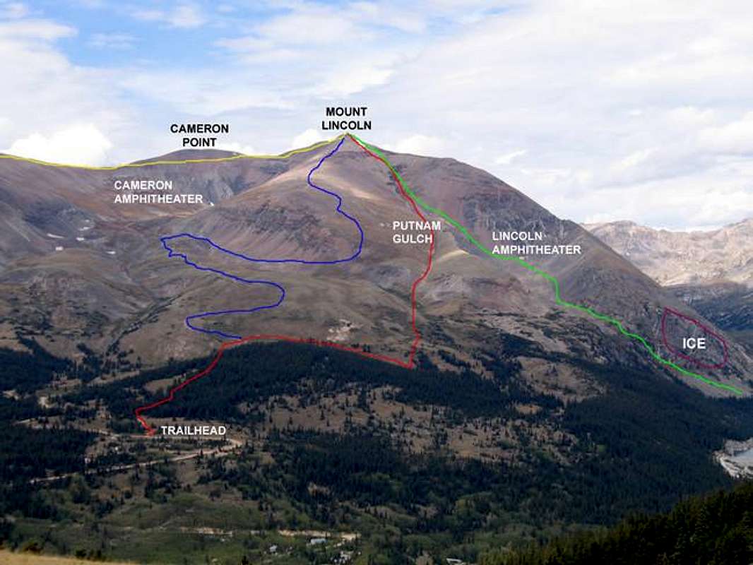
Route Photo for Mount Lincoln. This route is in red
 |  |
Essential Gear
Skis and skins. Appropriate winter gear.
An ice axe and crampons are not necessary for this route, provided you follow the low-angled terrain.
Ensure you have appropriate avalanche gear and knowledge. This should be obvious.
 |  |
Backcountry Ski Ratings and Disclaimer
Skiing in the backcountry is nothing like skiing at a resort. Ratings of "beginner," "intermediate," and "advanced" are backcountry ratings. They do not correspond to ski resorts. At ski resorts, beginner and intermediate runs are almost always groomed and cleared of obstacles. Not so in the backcountry. Expect to find rocks, trees, patchy snow, and all sorts of obstacles on the easiest of runs. Route selection and avalanche avoidance are also key to your safe navigation of backcountry ski terrain.
Don't think that you can safely ski a "beginner" backcountry route if you can ski green runs at resorts. It's like comparing apples and oranges. Being a "no falls" skier in all types of snow conditions is usually necessary before tackling backcountry terrain. Find an experienced partner or become an expert in resort terrain before trying backcountry.
Ok, lecture over. I just don't want anyone to get the wrong idea here and get hurt.
Avalanche Conditions and Information
Colorado Avalanche information Center's Website for current information on Mount Lincoln's region.
While this route is generally low-angled, there are several areas that could produce a serious slide. The most dangerous areas, in my mind, are:
- The 400 feet from the summit to the start of upper Putnam Gulch. This terrain has several areas that could produce a slide. This can be avoided by traveling on ridge tops.
- Upper Putnam Gulch from 13,900 feet to 13,100 feet. This gully has some higher angled areas that could send the slope running. Ski the edges of the upper gully in uncertain conditions.
Current Conditions
"Add Info" here about current conditions on this route. I'll cut and paste your post into the main text.
- May 14, 2005:
Trailhead snowed in to about 100 feet off the main road. The route is in excellent condition, allowing a summit ski to the beginning of the FS road.
300 feet below the Summit
Red Tape
ACCESS ISSUES:
All routes on Mt Lincoln, Mt Bross, and Mt Democrat are on private property.
The Forest Service originally distributed flyers in the area about the routes to all 3 summits being on private property. Kite Lake is public, the Bristlecone Pine area is public, but everything above them is not. The flyers caused millions of phone calls and grief for the Forest Service and the landowners. For instance, Mt Bross has over 50 owners. Mt Democrat and Lincoln don't have that many, but there are still quite a few.
So the Forest Service recently did the press releases that many of us saw in the Dever Post and other news outlets to limit phone calls to the rangers. This is where we currently stand. The land owners are concerned about liability issues, but so far, have not posted or blocked their land. They don't respond to phone calls or emails.
If you call the rangers, they will offer no information on routes and tell you that they are all on private property. This is the official FS stance.
Several organizations, including the Colorado Fourteeners Initiative, are currently trying to work out a plan that works for everyone.
My two cents: Continue to hike and climb here. Respect the land owners and avoid all posted property. Leave No Trace. Pick up trash. Travel in small groups. Give all mining areas a wide berth. Use established trails and roads.
Travel at your own risk.